
An interesting tip comes to us through Esri. Using these innovative tools, visitors can also explore key voting issues in the 2020 race such as criminal justice , healthcare or the environment.
UP42 Partners With Hexagon To Offer HxGN Content Program Aerial Imagery on Geospatial Marketplace

BERLIN, Germany, 20 October 2020 – High-resolution aerial imagery from the HxGN Content Program is now available on the UP42 developer platform for Earth observation data and analytics. UP42 customers may now choose from nearly 11 million square kilometers of 30 cm orthorectified imagery for North America and Europe and over 500,000 sq km of 15 […]
From Volcanoes to Vineyards – New Geologic Map Reveals Portland’s Deep History
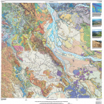
A new digital geologic map of the greater Portland-Vancouver-Hillsboro metropolitan area of Oregon and Washington being released today will support emergency response, conservation, agriculture and recreation.
Webinar – How to Quickly Generate High-Quality Orthomosaics

free webinar ‘How to Quickly Generate High-Quality Orthomosaics” – Learn about rapid image processing to produce accurate orthomosaics from SimActive.
Food Truck Finder App Launches in San Francisco @FoodTrux_App

PORTLAND, Maine, Sept. 24, 2020 – The food truck scene in San Francisco’s greater Bay Area is as rich in taste as it is diverse in cuisine – sourcing fresh, local ingredients from ocean waters to organic farmlands. San Francisco is the nations’ melting pot for cultural diversity, serving up some of the most exquisite culinary delights in the country.
HP Builds on Sustainability Commitment with First Consumer PCs Made with Ocean‐Bound Plastics

HP Builds on Sustainability Commitment with First Consumer PCs Made with Ocean‐Bound Plastics – Company brings premium mainstream with colorful and bold Pavilion notebooks
Maxar Satellite Imagery: Bobcat Wildfire, Northeast of Los Angeles

Maxar Technologies’ WorldView-3 satellite collected new images September 21 of the large Bobcat Fire burning northeast of Los Angeles, California.
Squadron of Private Planes from California Airlifts Medical Aid to Fire-Ravaged Oregon

A flying armada organized by volunteer pilots flying private aircraft today delivered 100,000 KN95 respirators from Direct Relief’s California-based humanitarian distribution center to residents and firefighters in Oregon’s worst-hit fire-zones.
Satellite Imagery: August Complex Fires, California

Maxar Technologies captured today (September 14) collected a set of satellite images of the August Complex wildfire, burning to the west of Chico, California and near the northern California coast.
2020 Commercial UAV Expo Americas to Take Place Virtually Next Week

UAS Solutions Providers and Thousands of End-Users will Gather Online Sep 15-17 for Expo and Conference Focused on Commercial Drones Portland, ME – September 10, 2020 – With Commercial UAV Expo Americas slated for September 15-17, organizers of the event have announced that they are expecting the participation of thousands of UAS professionals from around […]