
July 9, 2024 Mosaic, a leading provider of high-end terrestrial imagery hardware, is excited to announce a strategic partnership with ESRI, the global market leader in geographic information system (GIS) software, to support and enhance ESRI’s ArcGIS platform with Mosaic’s cutting-edge 360 imagery technology.
EagleView Technologies Appoints Piers Dormeyer to Chief Executive Officer
Former CEO, Chris Jurasek, Named Executive Chairman. New leadership will continue its commitment to revolutionize the aerial imagery business.
Ursa Space Launches Python Toolbox API on Esri ArcGIS Pro Software
ITHACA, N.Y., Feb. 13, 2023 /PRNewswire/ — Ursa Space Systems, a leading satellite-analytics-as-a-service provider, has announced the release of a Python toolbox for satellite analytic and data ordering within Esri ArcGIS Pro, a full-featured professional desktop GIS application.
Geospatial Imagery Analytics Global Market to Reach $25.04 Billion
DUBLIN, Sept. 13, 2022 /PRNewswire/ — The global geospatial imagery analytics market is expected to grow from $7.44 billion in 2021 to $9.57 billion in 2022 at a compound annual growth rate (CAGR) of 28.6%. The geospatial imagery analytics market is expected to grow to $25.04 billion in 2026 at a CAGR of 27.2%.
UP42 Adds BlackSky Dynamic Monitoring to Marketplace

On-demand access to low-latency dawn-to-dusk imagery
Soar.Earth supports community GoFundMe project to release historically significant satellite imagery

Soar.Earth helped one of their community members share special declassified spy satellite imagery with the world by supporting their personal GoFundMe initiative.
BlackSky Upgrades Customers’ Site Monitoring Experience with Enhanced Analytics and Imaging Capabilities
New features give users the ability to extract additional intelligence over sites of economic interest worldwide
Maxar Satellite Imagery: Flooding Along Fraser River, British Columbia
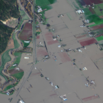
Maxar collected new satellite imagery on Friday (November 19th) of the ongoing flooding in Sumas Prairie to the east of Abbotsford, British Columbia, Canada. Highways, roads and many buildings and farms remain under water.
AerialSphere Joins the Esri ArcGIS Marketplace with a Nationwide Dataset of 360-Degree Imagery for ArcGIS

PHOENIX, Ariz. – November 8, 2021, AerialSphere, the only company to combine 360-degree aerial imagery with location data, today announced that they have made their nationwide dataset of 360-degree imagery available through the ArcGIS Marketplace. AerialSphere also announced they have earned Silver level partner status within the Esri Partner Network (EPN).
Maxar Satellite Imagery: Historic Images of 9/11 and the Upcoming 20th Anniversary

As we approach this Saturday’s 20th anniversary of the September 11, 2001 attacks, Maxar is providing a satellite imagery gallery of a number of the most significant sites that were collected shortly after the 2001 attacks, including: the American Airlines Flight 11 and United Airlines Flight 175 crash sites at the World Trade Center in New […]