
There is a huge sector of mobile gaming that has become an enormous segment of the gaming community, yet people feel constrained by their phone hardware. The fun can be stolen by small screens, battery depletion, overheating, and touch controls, particularly in the process of long gaming. This is where MuMuPlayer comes to rescue the […]
Golden Software Expands 3D Drillhole Visualization and Overall Usability in Surfer Mapping Package
GOLDEN, Colorado, 10 September 2025 – Golden Software has continued to enhance the 3D drillhole viewing functionality in the latest release of its Surfer mapping and 3D visualization software package. Overall, the new version of Surfer provides users with several upgrades to save time and streamline creation of subsurface maps.
Golden Software Enhances Box Plots Functions in Grapher Package for Faster Data Importing and Plotting
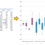
OLDEN, Colorado, 12 March 2024 – Golden Software, a leading developer of scientific graphing and visualization software, has added Grouped Box Plot functionality to make sensor data easier to import and plot in the latest version of its Grapher scientific graphing package. In addition, new Beta capabilities being tested in the release make the software more […]
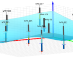
Latest Surfer® Mapping and 3D Visualization Package from Golden Software Gives Users Comprehensive View of Subsurface Data

GOLDEN, Colorado, 13 February 2024 – Golden Software has further enhanced the 3D visualization capabilities of its Surfer mapping and 3D visualization software to give users a complete picture of their subsurface data. The expanded visualization tools in the latest Surfer version make it easier than ever to create 3D grid files for the viewing and […]
Esri and National Geographic Society Launch National Geographic MapMaker
Newly Updated Online Interactive Mapping Tool Empowers Students, Teachers, and Individuals Everywhere to Explore the World through Geography
Five Popular Cloud Hosting Providers
In today’s digital age, cloud hosting has become a fundamental component of the technology landscape. It offers businesses and individuals the flexibility, scalability, and reliability needed to manage websites, applications, and data. Choosing the right cloud hosting provider is essential for a seamless online experience, which is why platforms like best Canadian online casino offers […]
Revolutionize Your Security Operations with Cutting-Edge Guard Patrol Software
The security of any organization is paramount. Whether managing a business, an academic institution, or a government agency, ensuring the safety of employees, customers, and property is essential. Many organizations are now turning to guard patrol software to achieve this effectively. By equipping guards with cutting-edge technology, such as security guard patrol software, organizations can […]
Esri Releases New Desktop Software to Easily Synthesize All Sources of Information

ArcGIS AllSource Connects Disparate Data, Enabling Actionable, Holistic Intelligence for Decision-Makers
SSP Innovations Announces Production Release of SSP Vision, Revolutionary New Field Data Capture Product
DENVER–(BUSINESS WIRE)–SSP Innovations, LLC (SSP) today announces the production release of SSP Vision, a revolutionary new field data capture product for utilities, telecommunications companies and any organization that manages geographically distributed assets.
Announcing TatukGIS SDK for Python

TatukGIS brings its GIS Developer Kernel, a professional GIS SDK, to the popular Python programming language. The comprehensive TatukGIS object-oriented API, with hundreds of classes and thousands of methods and properties designed for geospatial application development, is now available as a Python package for Windows, Linux, and macOS.