GIS user technology news

News, Business, Technology, Mobile, GIS, Crypto Currency, AI, Economics

  • PRESS
    • Submit PR
    • Top Press
    • Business
    • Software
    • Hardware
    • UAV News
    • Mobile Technology
  • FEATURES
    • Around the Web
    • Social Media Features
    • EXPERTS & Guests
    • Tips
    • Infographics
  • Events
  • CAREERS
  • Advertising and Sponsored Posts
    • Advertising and Sponsored Posts
    • Submit Press
  • Shop
  • Tradepubs
  • Around the Web
  • Cool Links
You are here: Home / Archives for * PRESS / DATA

Latest Surfer® Mapping and 3D Visualization Package from Golden Software Gives Users Comprehensive View of Subsurface Data

February 13, 2024 By GISuser

Import imagery, such as PNG files of geophysical profiles, and position the images in any orientation! Import any georeferenced images, such as an aerial image in GeoTIFF format, and it is placed directly in the correct location.

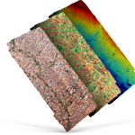
GOLDEN, Colorado, 13 February 2024 – Golden Software has further enhanced the 3D visualization capabilities of its Surfer mapping and 3D visualization software to give users a complete picture of their subsurface data. The expanded visualization tools in the latest Surfer version make it easier than ever to create 3D grid files for the viewing and […]

Filed Under: Business, DATA, Featured TOP PR, Software Tagged With: AND, Business, comprehensive, Data, featured, from, gives, golden, latest, Mapping, package, software, subsurface, surfer, top, users, view, visualization

TCarta Plans Bathymetric Mapping Workshop for Jamaica with Seabed 2030 Funding

February 5, 2024 By GISuser

DENVER, Colorado, 5 February 2024 – TCarta Marine, a global provider of hydrospatial products and services, will conduct a week-long coastal bathymetric mapping workshop for hydrographic surveyors in Jamaica. The workshop will be hosted by the Jamaica National Land      Agency (NLA) and funded by The Nippon Foundation-GEBCO Seabed 2030 project.

Filed Under: Business, DATA Tagged With: 2030, bathymetric, Business, Data, for, funding, Jamaica, Mapping, plans, seabed, TCarta, with, Workshop

New USGS map shows where the most damaging earthquakes are likely to occur in the US

February 4, 2024 By GISuser

USGS scientists and our partners recently revealed the latest National Seismic Hazard Model, showing that nearly 75% of the United States could experience a damaging earthquake, emphasizing seismic hazards span a significant part of the country.

Filed Under: DATA, Earth Imaging - Remote Sensing, Environment, Featured TOP PR Tagged With: are, damaging, Data, earth, earthquakes, environment, featured, imaging, likely, map, most, New, occur, remote, sensing, shows, the, top, USGS, Where

Maxar Intelligence Wins NGA Contract for Precision3D Data

January 13, 2024 By GISuser

WESTMINSTER, Colo.–(BUSINESS WIRE)–Maxar Intelligence, a provider of secure, precise, geospatial intelligence, today announced that it received a contract to provide the National Geospatial-Intelligence Agency (NGA) with a Precision3DTM Data Suite bundle covering 160,000 square kilometers within the U.S. Indo-Pacific Command area of responsibility.

Filed Under: DATA, Earth Imaging - Remote Sensing, Top Text Lead Story Tagged With: contract, Data, earth, featured, for, imaging, Intelligence, lead, maxar, NGA, precision3d, remote, sensing, story, text, top, Wins

Wildfire Preparedness: UP42 and OroraTech Facilitate Geospatial Data Access with On-Demand Sensor Tasking

December 1, 2023 By GISuser

Berlin/Munich, November 30, 2023 – UP42, a geospatial developer platform and marketplace, and OroraTech, the leader in space-based thermal intelligence, have signed a partnership agreement to grant easy and fast access to global high-resolution thermal-infrared imagery. OroraTech delivers low-latency, global coverage, near-real-time thermal data products.

Filed Under: Business, DATA, Featured TOP PR

EagleView Launches EagleView Developer

November 17, 2023 By GISuser

Developer provides a single point of access to EagleView’s suite of APIs, enabling developers unprecedented utilization of geospatial intelligence, measurements, and design tools powered by over 1 billion historical US and Canadian residential property images.

Filed Under: Business, DATA Tagged With: EagleView

Database and interactive map of all large-scale solar energy facilities in the U.S

November 8, 2023 By GISuser

SGS and Lawrence Berkeley National Laboratory Department of Energy release database and interactive map of all large-scale solar energy facilities in the U.S.

Filed Under: DATA Tagged With: solar, USGS

UP42 and GLOBHE Sign Partnership to Bring Drone Data to Geospatial Marketplace

November 8, 2023 By GISuser

GLOBHE's breadth of sensor availability, ranging from RGB, LiDAR, Multispectral and Thermal. (Image Credit: Isabelle Nyroth)

Customers can now task drones and browse drone data next to other types of imagery, all in one place.

Filed Under: Business, DATA Tagged With: UP42

Locafy Partners with TransUnion to Add 17 Million US Business Listings to Global Publishing Network

October 4, 2023 By GISuser

Strategic Commercial Partnership to Boost Locafy’s Publishing Network by 34% Locafy and TransUnion Collaborate to Automate SEO Products Based on Listing Content

Filed Under: Business, DATA

UP42 and Umbra Unveil Partnership at World Satellite Business Week, Enhancing Environmental, Asset, and Land Monitoring

September 15, 2023 By GISuser

Geospatial leaders release a special video to explain the benefits of easier access to high resolution SAR data.

Filed Under: Business, DATA Tagged With: SAR, UP42

Next Page »


featured podcast

Recent Features

Space Flight Laboratory (SFL) Announces Successful Launch & Deployment of HawkEye 360’s Cluster 11

FOSS4G NA 2024: The Premier Open Source Geospatial Conference Returns to St. Louis, September 9-11

Photographer Touch Reveal the Top Cameras, Lenses, and Photo Editing Tools of 2022

Digitalization and Simulation at the North Pole

Natural Gas District & GIS-Centric Asset Management

More Posts from this Category

Categories

Recent Posts

  • The Future of Travel: Marc Zboch Explores How Technology is Redefining the Journey from Booking to Boarding
  • Tips for Speeding Up the Sale: What Home Buyers Love
  • Top Guided Dune Buggy Tours with Expert Drivers by Buggy Dubai DXB
  • XRP adds nearly $100 billion since Ripple’s first major victory in SEC case
  • Top 5 Benefits of Using a Cat Harness and Leash for Indoor Cats

RSS Career Tips

  • Four Characteristics of the Best Virtual Employees
  • 28 Tools to Conquer the Social Media Recruiting World
  • 8 Questions Employers Should Ask About Coronavirus
  • Jobcase Launches Free Unemployment Resource Center for Workers Impacted by COVID-19
  • Must-Have Gadgets and Technology for the Remote Office Worker

RSS Tech pubs

  • Hands on Hacking: Become an Expert at Next Gen Penetration Testing and Purple Teaming ($45.00 Value) FREE for a Limited Time
  • AI First, Human Always: Embracing a New Mindset for the Era of Superintelligence ($17.00 Value) FREE for a Limited Time
  • Your team's tech shortcuts could cost you your business

RSS Computers

  • How the Cloud is Reshaping Virtual Desktops
  • Millennials as Brand Advocates - New Research Study Results
  • Vehicles Best Practices Installation Guide

RSS HR Tips

  • Future of Work: The APAC View
  • What Is an Agile Workspace?
  • Public Works & Utilities

RSS Gov Tech

  • Government Procurement: Technology: Solving Problems for Government
  • IWCE News Desk: Public Safety Communications
  • IWCE News Desk: Nemergent, Frequentis

RSS UAV news

  • DJI Matrice 4 Series Brings Intelligence to Aerial Operations
  • Virtual Surveyor Adds Productivity Tools to Mid-Level Smart Drone Surveying Software Plan
  • Nokia and Swisscom Broadcast to deploy largest Drones-as-a-Service network

RSS Geojobs

  • Senior Systems Administrator
Copyright gletham Communications 2011-2022

Go to mobile version