GIS user technology news

News, Business, AI, Technology, IOS, Android, Google, Mobile, GIS, Crypto Currency, Economics

  • Advertising & Sponsored Posts
    • Advertising & Sponsored Posts
    • Submit Press
  • PRESS
    • Submit PR
    • Top Press
    • Business
    • Software
    • Hardware
    • UAV News
    • Mobile Technology
  • FEATURES
    • Around the Web
    • Social Media Features
    • EXPERTS & Guests
    • Tips
    • Infographics
  • Blog
  • Events
  • Shop
  • Tradepubs
  • CAREERS
You are here: Home / Archives for **Front Page

The Global Expansion of Aueshah: A New Era of High Jewelry

April 11, 2026 By GISuser

KARACHI, PAKISTAN. The international luxury market is experiencing a profound shift. Consumers are increasingly rejecting mass-produced goods in favor of rarity, authenticity, and emotional depth. Leading this transformation is Aueshah, a bespoke jewelry house that is actively challenging the European monopoly on high end design. By merging forty years of heritage with advanced authentication technology, […]

Filed Under: Top Press

Golden Software Expands 3D Drillhole Visualization and Overall Usability in Surfer Mapping Package

September 10, 2025 By GISuser

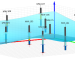
GOLDEN, Colorado, 10 September 2025 – Golden Software has continued to enhance the 3D drillhole viewing functionality in the latest release of its Surfer mapping and 3D visualization software package. Overall, the new version of Surfer provides users with several upgrades to save time and streamline creation of subsurface maps.

Filed Under: Around the Web, Business, HUGE NEWS, Software

State of Data Science Report – AI and Open Source at Work

September 10, 2025 By GISuser

State of Data Science Report

AI and Open Source at Work

Filed Under: Around the Web, Business, Featured TOP PR, HUGE NEWS, Top Press

Topcon Announces Landmark Expansion of Topnet Live Network Across USA

January 26, 2025 By GISuser

Landmark Expansion of Topnet Live Network

LIVERMORE, Calif.—Topcon Positioning Systems has announced a significant expansion of its Topnet Live reference station network, introducing 200 new geodetic stations strategically positioned across the United States. This comprehensive network upgrade expands the availability of advanced centimeter-level accuracy for precision-critical industries, including engineering, surveying, construction, and agricultural sectors.

Filed Under: Top Press Tagged With: across, announces, expansion, Field GIS, Landmark, live, Mobile Mapping, network, press, top, Topcon, topnet, USA

New Episode Alert: The Future of Wearable Reality Capture Systems

January 25, 2025 By GISuser

NavVis unveiled its new MLX handheld laser scanner for reality capture at INTERGEO in September 2024.

Filed Under: Around the Web, Business, Events, LiDAR, Top Text Lead Story Tagged With: alert,”, around, business:, capture, episode, events:, future:, lead, LiDAR, New, reality, story, systems, text, the, top, wearable, web

Space Flight Laboratory (SFL) Announces Launch and Deployment of NorSat-4 Maritime Monitoring Microsatellite

January 19, 2025 By GISuser

Seventh Satellite Developed by SFL for Norway

Filed Under: Around the Web, Business, Business, Top Press Tagged With: (sfl), AND, announces, around, business:, deployment, flight, laboratory, launch, maritime, microsatellite, monitoring, norsat-4, press, space, the, top, web

HERE and BMW Group extend partnership on AI-powered mapping system

January 8, 2025 By GISuser

HERE and BMW Group extend partnership on AI-powered mapping system for automated driving and enhanced road safety

Filed Under: Around the Web, Business, GPS, Top Press Tagged With: ai-powered, AND, around, bmw, business:, extend, GPS, group, HERE, Mapping, partnership, press, system, the, top, web

HERE and AWS Collaborate on New HERE AI Mapping Solutions

January 6, 2025 By GISuser

HERE and AWS Collaborate on New HERE AI Mapping Solutions to Accelerate the Development of Software-Defined Vehicles

Filed Under: Around the Web, Business, Featured TOP PR Tagged With: AND, around, aws, business:, collaborate, featured, HERE, Mapping, New, solutions, the, top, web

World Lidar Day Returns for its Second Annual Celebration on February 12, 2025

December 31, 2024 By GISuser

Global event shines spotlight on the transformative power of lidar technology with celebrations at Geo Week in Denver, Colorado.

Filed Under: Business, LiDAR, Top Text Lead Story Tagged With: 12,, 2025, annual, business:, celebration, day, february, for, it’s, lead, LiDAR, returns, second, story, text, top, world

Space Flight Laboratory (SFL) Announces Successful Launch & Deployment of HawkEye 360’s Cluster 11

December 31, 2024 By GISuser

Developed in SFL Flex Production Program

Filed Under: Business, Top Features Tagged With: (sfl), 360’s, announces, business:, cluster, deployment, features,, flight, hawkeye, laboratory, launch, space, successful, top

Next Page »

Recent Industry News

Why Bathroom Renovation Services Often Change More Than Just the Bathroom

May 20, 2026 By GISuser

The Drift Between Early Notes and Final Case Files in Abuse-Related Legal Support

April 29, 2026 By GISuser

Aerial Surveys Int’l and Global Marketing Insights to Present GEOINT 2026 Workshop on Multi-Domain Geospatial Fusion for Automated Infrastructure Monitoring

April 24, 2026 By GISuser

Why Timing Matters More Than You Think With Spray Seal (And Why People Often Get It Slightly Wrong)

April 22, 2026 By GISuser

Hot News

State of Data Science Report – AI and Open Source at Work

HERE and AWS Collaborate on New HERE AI Mapping Solutions

Virtual Surveyor Adds Productivity Tools to Mid-Level Smart Drone Surveying Software Plan

Categories

Copyright gletham Communications 2015 - 2026

Go to mobile version