GIS user technology news

News, Business, AI, Technology, IOS, Android, Google, Mobile, GIS, Crypto Currency, Economics

  • Advertising & Sponsored Posts
    • Advertising & Sponsored Posts
    • Submit Press
  • PRESS
    • Submit PR
    • Top Press
    • Business
    • Software
    • Hardware
    • UAV News
    • Mobile Technology
  • FEATURES
    • Around the Web
    • Social Media Features
    • EXPERTS & Guests
    • Tips
    • Infographics
  • Blog
  • Events
  • Shop
  • Tradepubs
  • CAREERS
You are here: Home / * PRESS / Business / Satellite Imagery: August Complex Fires, California

Satellite Imagery: August Complex Fires, California

September 14, 2020 By Editor

Maxar Technologies captured today (September 14) collected a set of satellite images of the August Complex wildfire, burning to the west of Chico, California and near the northern California coast.

The high off-nadir collections (satellite images collected at a steep angle)  taken by Maxar’s WorldView-2 satellite provide a dramatic view of the extensive line of fires burning to the north of Big Signal Peak (39.528N, 123.06W) and towering clouds of smoke. The August Complex fire became the largest fire in California history late last week and covers more than 750,000 acres.


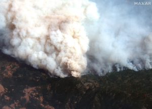
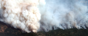
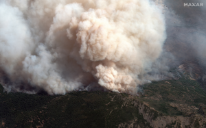
Satellite image ©2020 Maxar Technologies.

Filed Under: Business, Earth Imaging - Remote Sensing, Emergency Response, Featured TOP PR Tagged With: California, Imagery, maxar, wildfire

Editor’s Picks

Free Data from USGS Proves Its Worth for Observing Earth

Real Earth™ Wins Microsoft Competition for 3D Mapping and Localization

Social Media is an Increasingly Important Part of Webmaps, Data Analysis, Analytics and Visualizations

Blue Marble Announces Advanced LiDAR Option for the Global Mapper SDK

See More Editor's Picks...

About Editor

Glenn is a geographer and a GIS professional with over 20 years experience in the industry. He's the co-founder of GISuser and several other technology web publications.

Recent Industry News

Milwaukee M18FHZ-0 Hackzall Reciprocating Saw – For hardcore cutting in a compact size

June 19, 2026 By GISuser

How Enterprises Are Using AI to Automate 80% of Customer Interactions With Voice Agents

June 16, 2026 By GISuser

Why On Cloud Shoes Are Worth the Price in Mexico

June 16, 2026 By GISuser

Jinghong vs XAG Agricultural Drones: A Comprehensive Comparison Guide

June 16, 2026 By GISuser

Hot News

State of Data Science Report – AI and Open Source at Work

HERE and AWS Collaborate on New HERE AI Mapping Solutions

Virtual Surveyor Adds Productivity Tools to Mid-Level Smart Drone Surveying Software Plan

Categories

Copyright gletham Communications 2015 - 2026

Go to mobile version