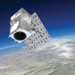
Vantor has rebranded from Maxar Intelligence and unveiled Tensorglobe, an AI-powered spatial intelligence platform. The rebrand represents the culmination of the company’s multi-year journey to productize its core operational technology and transform from a satellite imagery provider into an end-to-end spatial intelligence company.
Maxar Intelligence Wins NGA Contract for Precision3D Data

WESTMINSTER, Colo.–(BUSINESS WIRE)–Maxar Intelligence, a provider of secure, precise, geospatial intelligence, today announced that it received a contract to provide the National Geospatial-Intelligence Agency (NGA) with a Precision3DTM Data Suite bundle covering 160,000 square kilometers within the U.S. Indo-Pacific Command area of responsibility.
Maxar and Esri Expand Partnership to Visualize Precision3D™ in ArcGIS Living Atlas of the World
WESTMINSTER, Colo.–(BUSINESS WIRE)–Maxar Technologies, provider of comprehensive space solutions and secure, precise, geospatial intelligence, today announced that it will make its Precision3D data available for viewing in Esri’s ArcGIS Online Living Atlas of the World.
TCarta to Deliver Satellite Derived Bathymetry for 13 Regions to National Geospatial-Intelligence Agency
Work will be completed under contract to Maxar
NRO Exercises Radio Frequency Contract Option with Maxar

WESTMINSTER, Colo.–(BUSINESS WIRE)–Maxar Technologies (NYSE:MAXR) (TSX:MAXR), provider of comprehensive space solutions and secure, precise, geospatial intelligence, today announced that Aurora Insight Inc., a company acquired by Maxar in December 2022, has received a Stage II contract extension from the National Reconnaissance Office (NRO) for commercial radio frequency (RF) remote sensing.
Maxar Technologies To Be Acquired by Advent International for $6.4 Billion
Transaction will support Maxar to accelerate investment in and development of the Company’s next-generation satellite technologies and data insights for its customers
Maxar’s High-Resolution Vivid Basemaps Enhances Esri ArcGIS Living Atlas of the World

WESTMINSTER, Colo.–(BUSINESS WIRE)–Maxar Technologies (NYSE:MAXR) (TSX:MAXR), provider of comprehensive space solutions and secure, precise, geospatial intelligence, today announced that Esri, the global leader in geographic systems (GIS) and location intelligence, will enhance the World Imagery layer with higher resolution Maxar Vivid basemaps in the Living Atlas.
Maxar Awarded $202M in U.S. Government Mission Support Contracts
WESTMINSTER, Colo.–(BUSINESS WIRE)–Maxar Technologies (NYSE:MAXR) (TSX:MAXR), provider of comprehensive space solutions and secure, precise, geospatial intelligence, today announced it was awarded U.S. Government mission support contracts in Q1 2022 worth up to $202 million over a six-year period.
Maxar Extends 3D Geospatial Capabilities through Partnership with Blackshark.ai
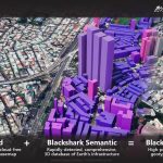
Maxar’s strategic investment layers its best-in-class satellite imagery with Blackshark.ai’s semantic 3D geospatial platform
Maxar Satellite Imagery: Mass grave found in Bucha, Ukraine

A mass grave has been identified in the town of Bucha, Ukraine, northwest of the capital of Kyiv.