GIS user technology news

News, Business, AI, Technology, IOS, Android, Google, Mobile, GIS, Crypto Currency, Economics

  • Advertising & Sponsored Posts
    • Advertising & Sponsored Posts
    • Submit Press
  • PRESS
    • Submit PR
    • Top Press
    • Business
    • Software
    • Hardware
    • UAV News
    • Mobile Technology
  • FEATURES
    • Around the Web
    • Social Media Features
    • EXPERTS & Guests
    • Tips
    • Infographics
  • Blog
  • Events
  • Shop
  • Tradepubs
  • CAREERS
You are here: Home / Archives for USGS

New USGS map shows where the most damaging earthquakes are likely to occur in the US

February 4, 2024 By GISuser

USGS scientists and our partners recently revealed the latest National Seismic Hazard Model, showing that nearly 75% of the United States could experience a damaging earthquake, emphasizing seismic hazards span a significant part of the country.

Filed Under: DATA, Earth Imaging - Remote Sensing, Environment, Featured TOP PR Tagged With: are, damaging, Data, earth, earthquakes, environment, featured, imaging, likely, map, most, New, occur, remote, sensing, shows, the, top, USGS, Where

Database and interactive map of all large-scale solar energy facilities in the U.S

November 8, 2023 By GISuser

SGS and Lawrence Berkeley National Laboratory Department of Energy release database and interactive map of all large-scale solar energy facilities in the U.S.

Filed Under: DATA Tagged With: solar, USGS

New big game migration maps support conservation planning across the West

January 2, 2023 By GISuser

LARAMIE, Wyo.—The USGS, in partnership with state and Tribal wildlife agencies, today published the third volume in a series of new maps of big game migration corridors. The new maps add more valuable tools for land managers and policy makers to mitigate the impacts of development on wildlife.

Filed Under: Environment Tagged With: conservation, USGS, wildlife

Woolpert Selected by USGS for Geospatial Products and Services Contract 4

September 17, 2021 By GISuser

The shared capacity contract will support federal, state and municipal government needs across the U.S.

Filed Under: Business Tagged With: USGS, Woolpert

National Imagery Summit SAVE THE DATE August 31, 2021 – September 2, 2021

April 30, 2021 By Editor

National Imagery Summit SAVE THE DATE August 31, 2021 - September 2, 2021

August 31, 2021 – September 2, 2021 – 12:00pm – 5:00pm EST Daily

Filed Under: Business, Earth Imaging - Remote Sensing, Events, Top Press Tagged With: Imagery, USGS

Wall Street Journal OpEd: USGS Gets Politics Out of Climate Forecasts

December 27, 2020 By Editor

DECEMBER 22, 2020 – USGS Director Reilly published an OpEd in the Wall Street Journal.

Filed Under: Environment Tagged With: environment, USGS

USGS Supports the 2020 National Space Policy

December 18, 2020 By Editor

DECEMBER 9, 2020 – In support of the President’s policy, USGS and NASA will leverage their full technological abilities to meet the nation’s growing environmental information needs.

Filed Under: Business Tagged With: USGS

USGS Unveils Mobile Flood Tool for the Nation

November 5, 2020 By Editor

USGS Unveils Mobile Flood Tool for the Nation

The U.S. Geological Survey announced Friday the completion of a new mobile tool that provides real-time information on water levels, weather and flood forecasts all in one place on a computer, smartphone or other mobile device.

Filed Under: Business, Mobile, Top Text Lead Story Tagged With: mobile, USGS

Preliminary Flood Maps for LaSalle Parish, La. are Ready for Public View

November 5, 2020 By Editor

Nov 2, 2020 – DENTON, Texas – Preliminary Flood Insurance Rate Maps (FIRMs) are available for review by residents and business owners in all communities and unincorporated areas of LaSalle Parish, La.  Officials encourage property owners to review the latest information to learn about local flood risks and potential future flood insurance requirements.     

Filed Under: Emergency Response, Environment Tagged With: flood map, USGS

From Volcanoes to Vineyards – New Geologic Map Reveals Portland’s Deep History

October 11, 2020 By Editor

Portland Geologic Map

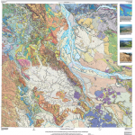
A new digital geologic map of the greater Portland-Vancouver-Hillsboro metropolitan area of Oregon and Washington being released today will support emergency response, conservation, agriculture and recreation.

Filed Under: Environment, Featured TOP PR, Maps and Cartography Tagged With: geology, Portland, USGS

Next Page »

Recent Industry News

Eagleview White Paper Warns: Geospatial Intelligence Is About to Change Forever

March 4, 2026 By GISuser

Can You Use A Bong As A Dab Rig? What You Should Know

March 3, 2026 By GISuser

This advancement, which will save customers time and money, also  is a critical step towards Eagleview’s goal of building fully remote, scalable property intelligence and turning aerial data into actionable, interactive 3D models for planning, assessment, and decision-making.

February 26, 2026 By GISuser

Hot News

State of Data Science Report – AI and Open Source at Work

HERE and AWS Collaborate on New HERE AI Mapping Solutions

Categories

Copyright Spatial Media LLC 2003 - 2015

Go to mobile version