GISuser.com

GIS and Technology news for mapping professionals

  • PRESS
    • Submit PR
    • Top Press
    • Business
    • GIS, Geo Tech Software
    • Hardware
    • UAV News
    • Mobile Technology
    • Editor’s Top Picks
    • Get TOP Listing!
  • FEATURES
    • GeoGeeksinCars
    • 10 Question Q&A
    • FROM THE EDITOR
    • SPATIAL MEDIA AUTHORS
    • Social Media Features
    • EXPERTS & Guests
    • Listicles and Top 10 Lists
    • Infographics
    • VIDEOS
  • Events
    • Webinars
    • Submit event
    • Event Media Partner
  • CAREERS
    • Career Help Articles
    • People and Career News
    • Work from Home
    • About GeoJobs.BIZ
  • About
    • Advertise
      • Advertise wth GISuser
      • Media Kit Request Form
      • Directory
      • Submit Press
    • Contact GISuser
    • Meet the Editor
    • Social Media
      • AnyGeo Blog
      • GeoGeeks Podcast
      • Social Media Features
      • Like Us
    • SpatialMedia
      • LBSzone
      • LiDAR Magazine
      • Amerisurv
      • SymbianOne
    • RSS feed
  • Blog
  • Shop
  • Cloud Hosting
    • Amazon Cloud Hosting
    • WordPress cloud hosting
    • Dedicated servers USA
    • Linux Shared Hosting
    • Windows Shared Hosting
    • Web Development
    • SSL Certificate
  • Tradepubs
You are here: Home / Archives for geology

From Volcanoes to Vineyards – New Geologic Map Reveals Portland’s Deep History

October 11, 2020 By Editor

Portland Geologic Map

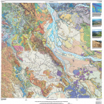
A new digital geologic map of the greater Portland-Vancouver-Hillsboro metropolitan area of Oregon and Washington being released today will support emergency response, conservation, agriculture and recreation.

Filed Under: Environment, Featured TOP PR, Maps and Cartography Tagged With: geology, Portland, USGS

Touch GIS App Introduces Digital Clino Tool for Geologists

May 14, 2020 By GISuser

Touch GIS App Introduces Digital Clino Tool for Geologists

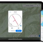
Touch GIS has introduced a digital clinometer tool to assist field geologist in recording strike & dip readings. Version 1.3 of the app also features a new ‘Attitude’ attribute type, which makes it easy to record and display these readings on the map.

Filed Under: Mobile, Software Tagged With: geology, Touch GIS

Oso Landslide Research Paves Way for Future Hazard Evaluations

March 17, 2015 By GISuser

osos landslide computer simulation model

VANCOUVER, Wash. — The large landslide that occurred on March 22, 2014 near Oso, Washington was unusually mobile and destructive.

Filed Under: Environment, Maps and Cartography Tagged With: geology, Mapping, Maps, Oso Landslide, USGS

Connect with GISuser

  • Facebook
  • Google+
  • LinkedIn
  • RSS
  • Twitter


GIS jobs

Recent Features

Digitalization and Simulation at the North Pole

Natural Gas District & GIS-Centric Asset Management

5 Ways Technology Is Affecting The Sharing Economy

Spotlight – Township Canada: Explore Canadian Legal Land Descriptions on a Map

GeoGeeksinCars – The one in “Tippy” the right-hand drive Mitsubishi, at DevSummit

More Posts from this Category

Categories


Recent Posts

  • Suffolk Launches International Women’s Month With Pledge to Increase Career Opportunities for Women in Construction and STEM
  • DeVry University Helps Close Opportunity Gap for Women in Technology
  • Commercial UAV Expo Americas Advisory Board Announced
  • TCarta Awarded NOAA Grant to Enhance Satellite Derived Bathymetry Technology in Alaskan Waters
  • Five Indispensable Skills For The Future of Work

RSS Career Tips

  • Four Characteristics of the Best Virtual Employees
  • Jobcase Launches Free Unemployment Resource Center for Workers Impacted by COVID-19
  • 8 Questions Employers Should Ask About Coronavirus
  • Must-Have Gadgets and Technology for the Remote Office Worker
  • Must-Have Gadgets and Technology for the Remote Office Worker


shop for geogeek swag

RSS Tech pubs

  • The Controller's Guide to Payables Automation
  • Accounts Payable: Embracing the Strategic Evolution
  • Avoiding the Risks of Financial Fraud

RSS Computers

  • iPad CTO Kit - including the iPad Tips and Tricks Guide for IT Executives and Managers
  • The Essentials of Information Security Kit: Includes a Free PC Security Handbook - 2nd Edition eBook
  • Windows... On Speed

RSS HR Tips

  • Post-Coronavirus Office Checklist
  • Fiduciary of the Future
  • Creating A Secure Remote Work Environment eBook

RSS Gov Tech

  • Next-generation Situational Awareness - How Skydio's autonomous drone solutions protect first responders
  • AI Meets Inspection: How Autonomous Drones are Changing the Game in Enterprise
  • Cyberwarfare Requires Speed, Adaptability and Visibility to Win: Enterprises Must Close the IT Operations and Security Gap

RSS UAV news

  • Global Commercial Drone Market Expected to Exceed $8.5 Billion By 2027
  • Down to Earth – Drone Lidar Surveying Reality Series Returns
  • Florida Signs Participating Addendum with DroneUp Providing Public Sector Agencies Access to Drone Services

RSS Geojobs

  • An error has occurred, which probably means the feed is down. Try again later.
Copyright Spatial Media LLC 2003 - 2015