Esri providers deliver best-in-class consulting, development services, and more
Wejo CEO & Founder Richard Barlow wins Disruptor category in EY Entrepreneur of the Year Awards in the UK

Professional services firm EY has announced that Richard Barlow, CEO and Founder of Wejo, the world’s leading connected car data company, has won the Disruptor category in its UK Entrepreneur of the Year award 2020.
Webinar – How to Accurately Merge Imagery with LiDAR

Webinar – How to Accurately Merge Imagery with LiDAR, Thursday, December 10th
Free eBook – JavaScript: Best Practice

This book presents modern JavaScript best practice, utilizing the features now available in the language, enabling you to write more powerful code that is clean, performant, maintainable, and resusable.
Satellite Imagery: Aftermath of Hurricane Iota in Providencia Island, Colombia @Maxar

Maxar Technologies collected new satellite imagery yesterday (November 21st) of the small Colombian island of Providencia, which suffered extreme damage from Hurricane Iota. Nearly all of the island’s infrastructure was destroyed from the powerful category 5 storm that struck the island on November 16th
Esri Announces Launch of ArcGIS Field Maps

Cutting-Edge App Delivers Multi-Functional Capabilities to Support Field Workflows
Virtual Surveyor Introduces Curb & Gutter Mapping in New Version of Drone Surveying Software
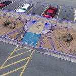
AARSCHOT, Belgium, 2 November 2020 – Virtual Surveyor has introduced Curb & Gutter mapping functionality in Version 7.6 of its popular drone surveying software. The new capability enables surveyors to create a lightweight CAD model of curbs and gutters along the edges of streets and parking lots from standard orthophotos and elevation models captured by unmanned […]
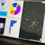
4 Approaches to Data Analytics for Your Application

The world of data analytics companies is changing fast as organizations look to gain competitive advantages through the application of timely data.
Satellite Imagery @Maxar : Southern California’s Blue Ridge and Silverado Wildfires

Maxar Technologies collected new satellite imagery yesterday (October 28th) of the Blue Ridge and Silverado Wildfires that rapidly spread over the past couple of days in southern California, threatening multiple cities including Yorba Linda, Chino Hills and Irvine, California.
Safe Spacer wearable social distancing monitor is now available

Electronic safety device also provides multiple options for compliance monitoring, data download and charging via a range of accessories