
GOLDEN, Colorado, 11 March 2025 – Golden Software has added the ability to download georeferenced Google aerial and satellite images to map projects in the latest version of its Surfer mapping and 3D visualization package. Other new features focus on faster and simpler creation of 3D visualizations that are easier to interpret and understand.
Golden Software Enhances Surfer® Mapping and 3D Visualization Package with Map Templates and Online Image Access
GOLDEN, Colorado, 11 September 2024 – Golden Software has added significant time-saving features to the latest version of its Surfer mapping and 3D visualization software. Users can now choose from more than 20 frame templates to quickly create their maps and project files. They can also easily download georeferenced aerial and satellite images from new online […]
Latest Surfer® Mapping and 3D Visualization Package from Golden Software Gives Users Comprehensive View of Subsurface Data

GOLDEN, Colorado, 13 February 2024 – Golden Software has further enhanced the 3D visualization capabilities of its Surfer mapping and 3D visualization software to give users a complete picture of their subsurface data. The expanded visualization tools in the latest Surfer version make it easier than ever to create 3D grid files for the viewing and […]
Latest Surfer® Mapping and 3D Visualization Package from Golden Software Gives Users Comprehensive View of Subsurface Data
GOLDEN, Colorado, 13 February 2024 – Golden Software has further enhanced the 3D visualization capabilities of its Surfer mapping and 3D visualization software to give users a complete picture of their subsurface data. The expanded visualization tools in the latest Surfer version make it easier than ever to create 3D grid files for the viewing and […]
Golden Software Enhances Grid Displays and Data Coordinate Conversion in Latest Surfer® Surface Mapping Package

GOLDEN, Colorado, 14 September 2022 – Golden Software, a developer of affordable 2D and 3D scientific modeling packages, has upgraded its Surfer® gridding, contouring, and 3D surface mapping package with improved grid display and data coordinate conversion options.
Golden Software Facilitates Map Making and Data Export in Latest Surfer® Surface Mapping Package

GOLDEN, Colorado, 11 January 2022 – Golden Software, a developer of affordable 2D and 3D scientific modeling packages, has enhanced the map-making functionality and data exporting capabilities in the latest version of its Surfer surface mapping package.
Golden Software Unveils 3D Drillhole Visualization in Surfer® Surface Mapping Package

GOLDEN, Colorado, 14 September 2021 – Golden Software, a developer of affordable 2D and 3D scientific modeling packages, has introduced a powerful new drillhole mapping tool that allows users to visualize in 3D the location and subsurface route of underground wells. The drillhole feature is one of several new capabilities in the latest release of Surfer […]
Golden Software Enhances Surfer® Visualization Functionality for Deeper Data Insights
GOLDEN, Colorado, 12 January 2021 – Golden Software, a developer of affordable 2D and 3D scientific modeling packages, has enhanced visualization and other functionality in the new version of its Surfer gridding, contouring and 3D surface mapping package. Surfer users now have a greater number of options for displaying their scientific data in the new version.
Golden Software Improves Surfer® File Handling for Faster Mapping

GOLDEN, Colorado, 9 September 2020 – Golden Software, a developer of affordable 2D and 3D scientific modeling packages, has made it faster and easier than ever to create maps in the latest version of its Surfer® gridding, contouring, and 3D surface mapping product. Additionally, Surfer users will find it is simpler to present, share and […]
Archaeologist Maps Artifacts with Surfer Software, Gains Unexpected Insights into Social Integration in 19th Century Mining Town
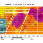
GOLDEN, Colorado, 19 November 2019 – A historical archaeologist made a surprising discovery about daily life in an 1800s gold mining town by mapping artifacts in the Surfer scientific modeling package from Golden Software. Artifact distribution maps indicate Highland City, Montana, may have been a well-integrated town for its time.