GIS user technology news

News, Business, AI, Technology, IOS, Android, Google, Mobile, GIS, Crypto Currency, Economics

  • Advertising & Sponsored Posts
    • Advertising & Sponsored Posts
    • Submit Press
  • PRESS
    • Submit PR
    • Top Press
    • Business
    • Software
    • Hardware
    • UAV News
    • Mobile Technology
  • FEATURES
    • Around the Web
    • Social Media Features
    • EXPERTS & Guests
    • Tips
    • Infographics
  • Blog
  • Events
  • Shop
  • Tradepubs
  • CAREERS
You are here: Home / Archives for golden

Full review of Golden Crown Casino for players from Australia

May 30, 2025 By GISuser

If you’re an Australian player looking for an exciting online gaming experience, Golden Crown Casino Australia might be the ideal choice for you. The casino, established in 2019, offers a robust selection of over 1,000 games ranging from slots and table games to live dealer options, ensuring a diverse gaming portfolio. Accessible via desktop and […]

Filed Under: Around the Web Tagged With: around, Australia, casino, crown, for, from, full, golden, players, review, the, web

How progressive jackpots work at Golden Panda Casino

April 30, 2025 By GISuser

Progressive jackpots offer an exhilarating opportunity to win life-changing sums of money, and at Goldenpanda Casino, these jackpots are among the most enticing attractions. These jackpots accumulate over time as a small percentage of each player’s bet contributes to a growing pool that can be won at any moment by a lucky player. The allure […]

Filed Under: Around the Web Tagged With: around, casino, golden, how, jackpots, panda, progressive, the, web, work

Golden Software Upgrades Surfer Mapping Package with Google Maps Downloads and Enhanced 3D Visualization

March 13, 2025 By GISuser

GOLDEN, Colorado, 11 March 2025 – Golden Software has added the ability to download georeferenced Google aerial and satellite images to map projects in the latest version of its Surfer mapping and 3D visualization package. Other new features focus on faster and simpler creation of 3D visualizations that are easier to interpret and understand.

Filed Under: * PRESS Tagged With: AND, business:, downloads, enhanced, golden, google, Mapping, Maps, package, press, software:, surfer, upgrades, visualization, with

Golden Pokies Casino: Your Ultimate Aussie Online Gaming Destination

February 25, 2025 By GISuser

If you’re on the hunt for a top-tier online casino experience, Golden Pokies has got you covered! 🇦🇺 With a dazzling selection of pokies, high-stakes table games, and lucrative promotions, Golden Pokies Casino delivers a thrilling and rewarding experience for Australian players. Whether you’re after classic pokies, modern video slots, or immersive live dealer games, […]

Filed Under: Around the Web Tagged With: around, aussie, casino, destination, gaming, golden, online, pokies, the, ultimate, web, your

Golden Software Improves Grapher Scientific Graphing Package for Greater Ease of Use, Faster Learning

October 13, 2024 By GISuser

GOLDEN, Colorado, 10 October 2024 – Golden Software, a leading developer of mapping, plotting, and visualization software, has improved numerous features in its Grapher scientific graphing package to provide greater ease of use to both long-time and first-time users. In addition, Grapher file menus and command ribbons have been simplified to enhance overall discoverability and user […]

Filed Under: * PRESS Tagged With: ease, Faster, for, golden, grapher, graphing, greater, improves, learning, package, press, scientific, software:, use

Golden Software Enhances Surfer® Mapping and 3D Visualization Package with Map Templates and Online Image Access

September 11, 2024 By GISuser

GOLDEN, Colorado, 11 September 2024 – Golden Software has added significant time-saving features to the latest version of its Surfer mapping and 3D visualization software. Users can now choose from more than 20 frame templates to quickly create their maps and project files. They can also easily download georeferenced aerial and satellite images from new online […]

Filed Under: Business Tagged With: access, AND, business:, enhances, golden, image, map, Mapping, online, package, software:, surfer, templates, visualization, with

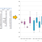
Golden Software Enhances Box Plots Functions in Grapher Package for Faster Data Importing and Plotting
March 13, 2024 By GISuser

No more wrestling with pivot tables or manual data layout adjustments. Use your data as is to clearly visualize all data in one easy to create graph.

OLDEN, Colorado, 12 March 2024 – Golden Software, a leading developer of scientific graphing and visualization software, has added Grouped Box Plot functionality to make sensor data easier to import and plot in the latest version of its Grapher scientific graphing package. In addition, new Beta capabilities being tested in the release make the software more […]

Filed Under: Software Tagged With: AND, box, Data, enhances, Faster, for, functions, golden, grapher, importing, package, plots, plotting, software

Latest Surfer® Mapping and 3D Visualization Package from Golden Software Gives Users Comprehensive View of Subsurface Data

February 13, 2024 By GISuser

Import imagery, such as PNG files of geophysical profiles, and position the images in any orientation! Import any georeferenced images, such as an aerial image in GeoTIFF format, and it is placed directly in the correct location.

GOLDEN, Colorado, 13 February 2024 – Golden Software has further enhanced the 3D visualization capabilities of its Surfer mapping and 3D visualization software to give users a complete picture of their subsurface data. The expanded visualization tools in the latest Surfer version make it easier than ever to create 3D grid files for the viewing and […]

Filed Under: Business, DATA, Featured TOP PR, Software Tagged With: AND, Business, comprehensive, Data, featured, from, gives, golden, latest, Mapping, package, software, subsurface, surfer, top, users, view, visualization

Latest Surfer® Mapping and 3D Visualization Package from Golden Software Gives Users Comprehensive View of Subsurface Data

February 13, 2024 By GISuser

GOLDEN, Colorado, 13 February 2024 – Golden Software has further enhanced the 3D visualization capabilities of its Surfer mapping and 3D visualization software to give users a complete picture of their subsurface data. The expanded visualization tools in the latest Surfer version make it easier than ever to create 3D grid files for the viewing and […]

Filed Under: Around the Web Tagged With: AND, around, comprehensive, Data, from, gives, golden, latest, Mapping, package, software, subsurface, surfer, the, users, view, visualization, web

Top Press

The Global Expansion of Aueshah: A New Era of High Jewelry

April 11, 2026 By GISuser

KARACHI, PAKISTAN. The international luxury market is experiencing a profound shift. Consumers are increasingly rejecting mass-produced goods in favor of rarity, authenticity, and emotional depth. … [Read More...]

State of Data Science Report – AI and Open Source at Work

September 10, 2025 By GISuser

AI and Open Source at Work … [Read More...]

Topcon Announces Landmark Expansion of Topnet Live Network Across USA

January 26, 2025 By GISuser

LIVERMORE, Calif.---Topcon Positioning Systems has announced a significant expansion of its Topnet Live reference station network, introducing 200 new geodetic stations strategically positioned across … [Read More...]

Space Flight Laboratory (SFL) Announces Launch and Deployment of NorSat-4 Maritime Monitoring Microsatellite

January 19, 2025 By GISuser

Seventh Satellite Developed by SFL for Norway … [Read More...]

HERE and BMW Group extend partnership on AI-powered mapping system

January 8, 2025 By GISuser

HERE and BMW Group extend partnership on AI-powered mapping system for automated driving and enhanced road safety … [Read More...]

SFL Missions Inc. Confirms Successful Deployment of Six HawkEye 360 Radio Frequency Detection Satellites with Advanced Capabilities

October 27, 2026 By GISuser

MĀHIA, New Zealand, 26 October 2026 – SFL Missions Inc. today confirmed the successful deployment of six radio frequency (RF) detection and geolocation satellites for HawkEye 360 … [Read More...]

Canadian-Built RoadEng 12 Uses AI to Find the Best Location for New Resource and Rural Roads

October 17, 2026 By GISuser

Vancouver, BC, Canada, October 15, 2026 – North Vancouver-based Softree Technical Systems today released RoadEng Version 12, used in more than 75 countries to locate and design … [Read More...]

Beyond the Map: How AI Image and Video Generation Is Changing Geospatial Communication

October 14, 2026 By GISuser

Ask anyone who has shipped a GIS project what the hardest part was, and the answer is rarely the spatial analysis. It is almost always the communication. A site suitability … [Read More...]

From Maternity to Everyday Wear: Building a Wardrobe That Grows With You

October 14, 2026 By GISuser

When I think about maternity clothing, I feel the biggest mistake is buying too many things at once. During pregnancy, your body keeps changing, and something that fits well today … [Read More...]

eMMC 5.1 Explained: Features, Performance, and Applications in Modern Devices

October 14, 2026 By GISuser

Storage technology is an essential part of modern computing, influencing how devices store information, launch applications, and manage everyday workloads. Although … [Read More...]

Copyright gletham Communications 2015 - 2026

Go to mobile version