GIS user technology news

News, Business, AI, Technology, IOS, Android, Google, Mobile, GIS, Crypto Currency, Economics

  • Advertising & Sponsored Posts
    • Advertising & Sponsored Posts
    • Submit Press
  • PRESS
    • Submit PR
    • Top Press
    • Business
    • Software
    • Hardware
    • UAV News
    • Mobile Technology
  • FEATURES
    • Around the Web
    • Social Media Features
    • EXPERTS & Guests
    • Tips
    • Infographics
  • Blog
  • Events
  • Shop
  • Tradepubs
  • CAREERS
You are here: Home / Archives for package

Golden Software Upgrades Surfer Mapping Package with Google Maps Downloads and Enhanced 3D Visualization

March 13, 2025 By GISuser

GOLDEN, Colorado, 11 March 2025 – Golden Software has added the ability to download georeferenced Google aerial and satellite images to map projects in the latest version of its Surfer mapping and 3D visualization package. Other new features focus on faster and simpler creation of 3D visualizations that are easier to interpret and understand.

Filed Under: * PRESS Tagged With: AND, business:, downloads, enhanced, golden, google, Mapping, Maps, package, press, software:, surfer, upgrades, visualization, with

Golden Software Improves Grapher Scientific Graphing Package for Greater Ease of Use, Faster Learning

October 13, 2024 By GISuser

GOLDEN, Colorado, 10 October 2024 – Golden Software, a leading developer of mapping, plotting, and visualization software, has improved numerous features in its Grapher scientific graphing package to provide greater ease of use to both long-time and first-time users. In addition, Grapher file menus and command ribbons have been simplified to enhance overall discoverability and user […]

Filed Under: * PRESS Tagged With: ease, Faster, for, golden, grapher, graphing, greater, improves, learning, package, press, scientific, software:, use

Golden Software Enhances Surfer® Mapping and 3D Visualization Package with Map Templates and Online Image Access

September 11, 2024 By GISuser

GOLDEN, Colorado, 11 September 2024 – Golden Software has added significant time-saving features to the latest version of its Surfer mapping and 3D visualization software. Users can now choose from more than 20 frame templates to quickly create their maps and project files. They can also easily download georeferenced aerial and satellite images from new online […]

Filed Under: Business Tagged With: access, AND, business:, enhances, golden, image, map, Mapping, online, package, software:, surfer, templates, visualization, with

Golden Software Enhances Box Plots Functions in Grapher Package for Faster Data Importing and Plotting

March 13, 2024 By GISuser

No more wrestling with pivot tables or manual data layout adjustments. Use your data as is to clearly visualize all data in one easy to create graph.

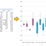
OLDEN, Colorado, 12 March 2024 – Golden Software, a leading developer of scientific graphing and visualization software, has added Grouped Box Plot functionality to make sensor data easier to import and plot in the latest version of its Grapher scientific graphing package. In addition, new Beta capabilities being tested in the release make the software more […]

Filed Under: Software Tagged With: AND, box, Data, enhances, Faster, for, functions, golden, grapher, importing, package, plots, plotting, software

Latest Surfer® Mapping and 3D Visualization Package from Golden Software Gives Users Comprehensive View of Subsurface Data

February 13, 2024 By GISuser

Import imagery, such as PNG files of geophysical profiles, and position the images in any orientation! Import any georeferenced images, such as an aerial image in GeoTIFF format, and it is placed directly in the correct location.

GOLDEN, Colorado, 13 February 2024 – Golden Software has further enhanced the 3D visualization capabilities of its Surfer mapping and 3D visualization software to give users a complete picture of their subsurface data. The expanded visualization tools in the latest Surfer version make it easier than ever to create 3D grid files for the viewing and […]

Filed Under: Business, DATA, Featured TOP PR, Software Tagged With: AND, Business, comprehensive, Data, featured, from, gives, golden, latest, Mapping, package, software, subsurface, surfer, top, users, view, visualization

Latest Surfer® Mapping and 3D Visualization Package from Golden Software Gives Users Comprehensive View of Subsurface Data

February 13, 2024 By GISuser

GOLDEN, Colorado, 13 February 2024 – Golden Software has further enhanced the 3D visualization capabilities of its Surfer mapping and 3D visualization software to give users a complete picture of their subsurface data. The expanded visualization tools in the latest Surfer version make it easier than ever to create 3D grid files for the viewing and […]

Filed Under: Around the Web Tagged With: AND, around, comprehensive, Data, from, gives, golden, latest, Mapping, package, software, subsurface, surfer, the, users, view, visualization, web

Recent Industry News

Why Bathroom Renovation Services Often Change More Than Just the Bathroom

May 20, 2026 By GISuser

The Drift Between Early Notes and Final Case Files in Abuse-Related Legal Support

April 29, 2026 By GISuser

Aerial Surveys Int’l and Global Marketing Insights to Present GEOINT 2026 Workshop on Multi-Domain Geospatial Fusion for Automated Infrastructure Monitoring

April 24, 2026 By GISuser

Why Timing Matters More Than You Think With Spray Seal (And Why People Often Get It Slightly Wrong)

April 22, 2026 By GISuser

Hot News

State of Data Science Report – AI and Open Source at Work

HERE and AWS Collaborate on New HERE AI Mapping Solutions

Virtual Surveyor Adds Productivity Tools to Mid-Level Smart Drone Surveying Software Plan

Categories

Copyright gletham Communications 2015 - 2026

Go to mobile version