GIS user technology news

News, Business, AI, Technology, IOS, Android, Google, Mobile, GIS, Crypto Currency, Economics

  • Advertising & Sponsored Posts
    • Advertising & Sponsored Posts
    • Submit Press
  • PRESS
    • Submit PR
    • Top Press
    • Business
    • Software
    • Hardware
    • UAV News
    • Mobile Technology
  • FEATURES
    • Around the Web
    • Social Media Features
    • EXPERTS & Guests
    • Tips
    • Infographics
  • Around the Web
  • Events
  • Shop
  • Tradepubs
  • CAREERS
You are here: Home / Archives for Data

Tailoring Data Management to Your Business Needs: The Case for Custom Database Development

March 29, 2024 By GISuser

In the ever-evolving digital landscape, data has emerged as the driving force behind many of today’s most successful businesses. From streamlining operations to uncovering valuable insights, effective data management is no longer a luxury but a necessity for organizations of all sizes and across industries. While off-the-shelf database solutions can provide a starting point, they […]

Filed Under: Around the Web Tagged With: around, Business, case, custom, Data, database, development, for, management, needs, tailoring, the, web, your

Advancing Geographic Insights: The Use of Data Analysis in GIS

March 19, 2024 By GISuser

Image source: Pexels The geographic information systems (GIS) market is expected to boom to a massive $14.5 billion by 2025. This powerful technology has been a game-changer in exploring and understanding our world. Think of it as a useful toolbox for planners, researchers, and decision-makers. It lets them see, analyze, and visualize data in a […]

Filed Under: Around the Web Tagged With: advancing, Analysis, around, Data, Geographic, GIS, insights, the, use, web

Creating an Effective Data Resiliency Strategy

March 16, 2024 By GISuser

Data is a vital part of your organization. This is what drives business decisions and issues often pop up when data isn’t available. Whether the data loss is caused by natural or manmade disasters, business operations can grind to a halt when it’s not available. 

Filed Under: Around the Web Tagged With: around, creating, Data, effective, resiliency, strategy, the, web

Golden Software Enhances Box Plots Functions in Grapher Package for Faster Data Importing and Plotting

March 13, 2024 By GISuser

No more wrestling with pivot tables or manual data layout adjustments. Use your data as is to clearly visualize all data in one easy to create graph.

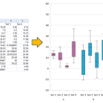
OLDEN, Colorado, 12 March 2024 – Golden Software, a leading developer of scientific graphing and visualization software, has added Grouped Box Plot functionality to make sensor data easier to import and plot in the latest version of its Grapher scientific graphing package. In addition, new Beta capabilities being tested in the release make the software more […]

Filed Under: Software Tagged With: AND, box, Data, enhances, Faster, for, functions, golden, grapher, importing, package, plots, plotting, software

From Data to Dollars: How OSS and BSS Networks Turn Information into Telecom Profits?

February 23, 2024 By GISuser

Imagine a treasure trove of insights hidden within your telecom network, waiting to be unlocked. That’s the potential of data in today’s digital landscape, and for telecom providers, it’s not just about understanding customer behavior; it’s about turning that understanding into real revenue. This is where Operation Support Systems (OSS) and Business Support Systems (BSS) […]

Filed Under: Around the Web Tagged With: AND, around, bss, Data, dollars:, from, how, information, into, networks, oss, profits?, telecom, the, turn, web

Latest Surfer® Mapping and 3D Visualization Package from Golden Software Gives Users Comprehensive View of Subsurface Data

February 13, 2024 By GISuser

Import imagery, such as PNG files of geophysical profiles, and position the images in any orientation! Import any georeferenced images, such as an aerial image in GeoTIFF format, and it is placed directly in the correct location.

GOLDEN, Colorado, 13 February 2024 – Golden Software has further enhanced the 3D visualization capabilities of its Surfer mapping and 3D visualization software to give users a complete picture of their subsurface data. The expanded visualization tools in the latest Surfer version make it easier than ever to create 3D grid files for the viewing and […]

Filed Under: Business, DATA, Featured TOP PR, Software Tagged With: AND, Business, comprehensive, Data, featured, from, gives, golden, latest, Mapping, package, software, subsurface, surfer, top, users, view, visualization

Latest Surfer® Mapping and 3D Visualization Package from Golden Software Gives Users Comprehensive View of Subsurface Data

February 13, 2024 By GISuser

GOLDEN, Colorado, 13 February 2024 – Golden Software has further enhanced the 3D visualization capabilities of its Surfer mapping and 3D visualization software to give users a complete picture of their subsurface data. The expanded visualization tools in the latest Surfer version make it easier than ever to create 3D grid files for the viewing and […]

Filed Under: Around the Web Tagged With: AND, around, comprehensive, Data, from, gives, golden, latest, Mapping, package, software, subsurface, surfer, the, users, view, visualization, web

TCarta Plans Bathymetric Mapping Workshop for Jamaica with Seabed 2030 Funding

February 5, 2024 By GISuser

DENVER, Colorado, 5 February 2024 – TCarta Marine, a global provider of hydrospatial products and services, will conduct a week-long coastal bathymetric mapping workshop for hydrographic surveyors in Jamaica. The workshop will be hosted by the Jamaica National Land      Agency (NLA) and funded by The Nippon Foundation-GEBCO Seabed 2030 project.

Filed Under: Business, DATA Tagged With: 2030, bathymetric, Business, Data, for, funding, Jamaica, Mapping, plans, seabed, TCarta, with, Workshop

New USGS map shows where the most damaging earthquakes are likely to occur in the US

February 4, 2024 By GISuser

USGS scientists and our partners recently revealed the latest National Seismic Hazard Model, showing that nearly 75% of the United States could experience a damaging earthquake, emphasizing seismic hazards span a significant part of the country.

Filed Under: DATA, Earth Imaging - Remote Sensing, Environment, Featured TOP PR Tagged With: are, damaging, Data, earth, earthquakes, environment, featured, imaging, likely, map, most, New, occur, remote, sensing, shows, the, top, USGS, Where

The 5 Benefits of Master Data Management You Need to Know

February 1, 2024 By GISuser

Are you tired of struggling with inaccurate and inconsistent data? Do you wish your business decisions were based on reliable and up-to-date information? Look no further, because Master Data Management (MDM) is the solution to all your data management woes. In this post, we will delve into the top benefits of master data and how […]

Filed Under: Around the Web, Business Tagged With: around, benefits, Business, Data, know, management, master, need?, the, web, you

Next Page »

Recent Posts

  • Decode the Hidden Value of Your Old Vehicle and Turn It from Scrap to Cash
  • 8 Live Dealer Game Formats You’ll Find in Malaysia
  • The Complete Guide to the UK ETA Application for First-Time Travelers
  • Top 3 WhatsApp Sticker Apps in 2025 (Android & iOS)
  • Exploring Dexsport Insights Features and Opportunities in Online Betting
  • Five Legal Myths That Cost Seattle Drivers Time and Money
  • Using GIS to Predict Workforce Shortages Caused by Medical and Family Emergencies
  • Full Spectrum vs Broad Spectrum vs Isolate: Choosing the Right CBD Gummies for You
  • Warm Roof vs Cold Roof: Why Modern Flat Roof Construction Favours PIR Above Deck
  • Why Customer Acquisition Without Retention Strategy Is Just Expensive Churn

Recent Features

Space Flight Laboratory (SFL) Announces Successful Launch & Deployment of HawkEye 360’s Cluster 11

FOSS4G NA 2024: The Premier Open Source Geospatial Conference Returns to St. Louis, September 9-11

Photographer Touch Reveal the Top Cameras, Lenses, and Photo Editing Tools of 2022

Digitalization and Simulation at the North Pole

Natural Gas District & GIS-Centric Asset Management

More Posts from this Category

Categories

RSS Career Tips

  • Four Characteristics of the Best Virtual Employees
  • 28 Tools to Conquer the Social Media Recruiting World
  • 8 Questions Employers Should Ask About Coronavirus
  • Jobcase Launches Free Unemployment Resource Center for Workers Impacted by COVID-19
  • Must-Have Gadgets and Technology for the Remote Office Worker


featured podcast

RSS Tech pubs

  • The Four Critical Pillars of Intent-aware FinOps
  • 4 Common FinOps Mistakes and How to Avoid Them
  • O'Reilly Cloud FinOps, 2nd Edition

RSS Computers

  • How the Cloud is Reshaping Virtual Desktops
  • Millennials as Brand Advocates - New Research Study Results
  • Vehicles Best Practices Installation Guide

RSS HR Tips

  • AWS GovCloud (US) Celebrates 10th Anniversary and a Decade of Digital Transformation in the Federal Government
  • Exploring the Impact of COVID-19 on Customer Behavior
  • The Pivot to 100% Remote Training in the Contact Center

RSS Gov Tech

  • 10 Legal Jobs You Can Get Without a Law Degree
  • J.D. Power Examines How the Inflation Reduction Act Reshapes EV Landscape
  • Making Telehealth Work for You: The Ultimate Guide

Copyright Spatial Media LLC 2003 - 2015

Go to mobile version