
Join with geospatial experts to solve your organization’s technology challenges and shape the future of location technologies
Spatial analysis examines UK beach capacity ahead of holiday season

2 July 2020 – Ahead of lockdown restrictions easing further on Saturday 4th July, Esri UK has examined how many people could hypothetically fit on some of the UK’s most popular beaches, following social distancing guidelines.
Saharan Air Layer Leaves Cuban Storm in the Dust
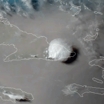
On June 23, 2020, the GOES-East satellite viewed the Saharan Air Layer (or SAL) over Cuba, while a storm erupted through its dusty haze. During this time of year, the SAL often blows westward from Africa’s Saharan Desert and can travel thousands of miles away. The SAL’s activity usually results in reduced severity— or in some cases […]
Virtual Surveyor Drone Surveying Software Simplifies Workflow for Earthworks Monitoring at Construction Sites

Fast Cut-and-Fill Calculations
Bay Park Data Solutions Announces Custom COVID-19 specific health surveys for essential workers and customers

Now offering COVID-19 specific health surveys for essential workers and customers – We have been working with Southern California remodeling and construction companies to help them provide peace of mind to their customers, employees, and trade workers during this unprecedented Coronavirus pandemic.
Satellite Imagery: Washington, DC and Black Lives Matter Street Mural

Maxar collected new satellite imagery this afternoon of Washington D.C. at 12:08 PM EDT that shows people gathered near the entrance to Lafayette Square and at the steps to the Lincoln Memorial.
Map of pavement widths helps local authorities with social distancing plans

Analysis reveals 70% of pavements are not wide enough for social distancing
SimActive Webinar: How to Calibrate and Process Multispectral Imagery

The team at SimActive will be hosting a second webinar next week ‘How to Calibrate and Process Multispectral Imagery’ on Thursday, June 11th:
Finnish Space Data Company Terramonitor launches a Web Store

Terramonitor launches a Web Store that provides easy access to analysis-ready satellite images and up-to-date satellite maps. By processing thousands of satellite images per day with AI and cloud computing, Terramonitor provides revolutionary tools for monitoring and analyzing the globe from space.
Coverage of Landmark NASA SpaceX Commercial Crew Test Flight

NASA will provide live coverage of prelaunch and launch activities for the agency’s SpaceX Demo-2 test flight on Wednesday, May 27, carrying NASA astronauts Robert Behnken and Douglas Hurley to the International Space Station.