GIS user technology news

News, Business, AI, Technology, IOS, Android, Google, Mobile, GIS, Crypto Currency, Economics

  • Advertising & Sponsored Posts
    • Advertising & Sponsored Posts
    • Submit Press
  • PRESS
    • Submit PR
    • Top Press
    • Business
    • Software
    • Hardware
    • UAV News
    • Mobile Technology
  • FEATURES
    • Around the Web
    • Social Media Features
    • EXPERTS & Guests
    • Tips
    • Infographics
  • Blog
  • Events
  • Shop
  • Tradepubs
  • CAREERS
You are here: Home / Archives for **Front Page / Top Text Lead Story

Woolpert Launches GeoAwareness Solution for Curbside Pickup Upon Arrival

August 17, 2020 By GISuser

GeoAwareness Solution for Curbside Pickup Upon Arrival

This quick-start, real-time solution streamlines operations and improves customer service.

Filed Under: Business, Software, Top Text Lead Story Tagged With: Woolpert

Esri Offers Students Free Access to GIS Software and Lessons

August 13, 2020 By GISuser

Learn ArcGIS

Learn ArcGIS Student Program Provides Self-Directed Learning Resources

Filed Under: EDU, Software, Top Text Lead Story Tagged With: arcgis

Beirut Explosion: Maxar Technologies, Before-and-After Satellite Imagery

August 5, 2020 By GISuser

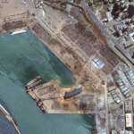
Several of Maxar’s satellites collected new imagery Aug 5, 2020 over Beirut that reveals the aftermath of the massive explosion in the port section of the city.

Filed Under: Earth Imaging - Remote Sensing, Top Text Lead Story Tagged With: Imagery, maxar

Esri and United Nations Create COVID-19 Population Vulnerability Dashboard

July 28, 2020 By GISuser

New Tool Will Help Public Health Organizations Use Census Data to Fight Pandemic

Filed Under: Emergency Response, Government & OpenGov, Top Text Lead Story Tagged With: COVID-19, dashboard, ESRI, UN

INTERGEO 2020 – your INTERGEO Berlin registration code

July 23, 2020 By GISuser

INTERGEO 2020 registration code

INTERGEO is the world’s largest, many think the best, GeoTech show of the year – perhaps the only thing that comes close is the annual International Esri UC! This year you can enjoy the show, Oct 13-15, 2020, direct from Berlin in the comfort of your home or office as you enjoy INTERGEO Virtual.

Filed Under: Events, Top Text Lead Story Tagged With: intergeo

Esri Announces New Additions to ArcGIS Platform at Virtual User Conference

July 17, 2020 By GISuser

Esri Announces New Additions to ArcGIS Platform at Virtual User Conference

New Location Datasets and an All-in-One Field App Included in 2020 Updates

Filed Under: Business, Software, Top Text Lead Story Tagged With: arcgis, ESRI, esriuc

GeoIgnite 2020 – Diversity in Leadership Panel

July 15, 2020 By GISuser

geoignite

Diversity in Leadership Panel: Canada’s Geospatial Ecosystem Join our award winning panelists for a discussion on Increasing the diversity, equity, and inclusiveness of the sector.

Filed Under: Events, Featured Event, Top Text Lead Story

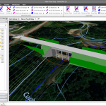
SimActive Software Used for Oil and Gas Seismic Exploration

July 10, 2020 By GISuser

Montreal, Canada, July 7th, 2020 – SimActive Inc., a world-leading developer of photogrammetry software, announces that its Correlator3D™ product is being used by Texas-based company Dawson Geophysical for oil and gas seismic exploration.  

Filed Under: Business, Software, Top Text Lead Story, UTILITIES Tagged With: SimActive

CivilGEO Releases GeoHECRAS Version 3.0

July 7, 2020 By GISuser

Wisconsin, July 07, 2020 – CivilGEO, a leading provider of civil engineering software, has released a new version of the GeoHECRAS software. GeoHECRAS Version 3.0 utilizes an improved and easier to operate FlexNet software licensing technology from Flexera Software. This latest release provides key new features, updates, and bug fixes.

Filed Under: Business, Software, Top Text Lead Story

INTERGEO 2020: 100 percent digital with a real network atmosphere

July 3, 2020 By GISuser

intergeo

INTERGEO 2020, the largest geospatial industry conference in the World, is going 100% virtual this year. Details from the organizers below.

Filed Under: Events, Top Press, Top Text Lead Story, Webinars Tagged With: intergeo

« Previous Page
Next Page »

Recent Industry News

Why Adults Are Trimming Their Routines for Travel and Busy Weeks

June 10, 2026 By GISuser

Top Benefits of AI Video Surveillance for Businesses and Public Spaces

June 5, 2026 By GISuser

How to Choose the Best Office Interior Designers in Delhi for End-to-End Projects

June 3, 2026 By GISuser

Why Bathroom Renovation Services Often Change More Than Just the Bathroom

May 20, 2026 By GISuser

Hot News

State of Data Science Report – AI and Open Source at Work

HERE and AWS Collaborate on New HERE AI Mapping Solutions

Virtual Surveyor Adds Productivity Tools to Mid-Level Smart Drone Surveying Software Plan

Categories

Copyright gletham Communications 2015 - 2026

Go to mobile version