GIS user technology news

News, Business, AI, Technology, IOS, Android, Google, Mobile, GIS, Crypto Currency, Economics

  • Advertising & Sponsored Posts
    • Advertising & Sponsored Posts
    • Submit Press
  • PRESS
    • Submit PR
    • Top Press
    • Business
    • Software
    • Hardware
    • UAV News
    • Mobile Technology
  • FEATURES
    • Around the Web
    • Social Media Features
    • EXPERTS & Guests
    • Tips
    • Infographics
  • Blog
  • Events
  • Shop
  • Tradepubs
  • CAREERS
You are here: Home / Archives for coronavirus

Allied Van Lines reports that amid the coronavirus pandemic Americans continued moving in 2020

December 23, 2020 By Editor

Business-friendly Texas leads the pack for corporate moves and Florida was the top state for consumer moves 

Filed Under: Business Tagged With: 2020, allied, americans, amid, business:, continued, coronavirus, lines, moving, pandemic, reports, that, the, van

Tourism Experience Management Platform WishTrip Releases Package to Help Tourism Destinations Reopen During Pandemic

August 20, 2020 By GISuser

This comes as tourist attractions, zoos and theme parks around the world seek better solutions to safely and profitably reopen their doors amid coronavirus

Filed Under: Business, Emergency Response Tagged With: coronavirus

U.S. Census Bureau Update to COVID-19 Interactive Data Hub

July 4, 2020 By GISuser

COVID-19 Interactive Data Hub

COVID-19 Demographic and Economic Resources from the United States Census Bureau

Filed Under: DATA, DATA FEATURES, Emergency Response, Top Press Tagged With: Census, coronavirus, covid19

Rebekah Jones @GeoRebekah , the fired GIS data scientist from Florida, Launches new #Coronavirus Dashboard, FloridaCOVIDAction

June 12, 2020 By GISuser

Florida's Community Coronavirus Dashboard

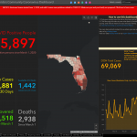
Remember Rebekah Jones, the fired GIS data scientist? Well, it seems she is following her passion to share public data and has deployed a new dashboard that shares coronavirus, health-related data from the state of Florida. Simply put… enter FloridaCOVIDAction.com.

Filed Under: Emergency Response, Maps and Cartography, Top Press Tagged With: coronavirus, dashboard, Florida

Bay Park Data Solutions Announces Custom COVID-19 specific health surveys for essential workers and customers

June 8, 2020 By GISuser

Now offering COVID-19 specific health surveys for essential workers and customers – ​We have been working with Southern California remodeling and construction companies to help them provide peace of mind to their customers, employees, and trade workers during this unprecedented Coronavirus pandemic.

Filed Under: Business, Emergency Response, Featured TOP PR, Mobile, Top Text Lead Story Tagged With: arcgis, bay park, coronavirus, ESRI, health survey

GISPs Contribute Through Geospatial Science & Data Management

June 5, 2020 By GISuser

Des Plaines, IL (June 5, 2020) – GISPs Contribute Through Geospatial Science & Data Management

Filed Under: Business Tagged With: coronavirus, COVID-19, GISCI

Map of pavement widths helps local authorities with social distancing plans

June 5, 2020 By GISuser

Analysis reveals 70% of pavements are not wide enough for social distancing

Analysis reveals 70% of pavements are not wide enough for social distancing

Filed Under: Business, DATA, Emergency Response, Government & OpenGov, Top Press, Top Text Lead Story Tagged With: coronavirus, ESRI, esri uk

Florida DOH GIS Data Manager Fired for Refusing to Alter and Censor COVID-19 Public Data

May 19, 2020 By GISuser

Rebekah Jones is the architect of Florida's COVID-19 dashboard

This from Florida Today: Late last Friday, the architect and manager of Florida’s COVID-19 dashboard — praised by White House officials for its accessibility — announced that she had been removed from her post, causing outcry from independent researchers now worried about government censorship.

Filed Under: Business, People, Hires, Career Tips, Top Press Tagged With: coronavirus, Florida

Esri Offers Free Access to GIS Training for Furloughed Professionals Affected by Coronavirus

May 12, 2020 By GISuser

learn arcgis

Complimentary Software and Lessons Support Learning during COVID-19 Outbreak

Filed Under: Business, Top Press Tagged With: coronavirus, COVID-19, ESRI

Nexar Announces $52 Million Series C Amid Rapid U.S. Growth, Launches On-Demand Data Product To Support Public Response To COVID-19

April 30, 2020 By GISuser

TEL AVIV, Israel, April 30, 2020 – Amid rapid U.S. growth, Nexar today announced $52 million in Series C funding and the launch of a new data product called Nexar Virtual Camera. This brings the vision-based software company’s total raised to date to nearly $100 million. The round is led by Corner Ventures with participation from Samsung NEXT, La Maison, Micron Ventures, […]

Filed Under: acquisitions and funding Tagged With: coronavirus, COVID-19

Next Page »

Recent Industry News

The Complete Guide to Buying Xxxxxxxxl Size Cxx Clothing: Fit, Comfort and Style Tips 

March 16, 2026 By GISuser

What Is In-Home Disability Care and How It Works With Five Good Friends

March 9, 2026 By GISuser

Eagleview White Paper Warns: Geospatial Intelligence Is About to Change Forever

March 4, 2026 By GISuser

Hot News

State of Data Science Report – AI and Open Source at Work

HERE and AWS Collaborate on New HERE AI Mapping Solutions

Categories

Copyright Spatial Media LLC 2003 - 2015

Go to mobile version