GIS user technology news

News, Business, AI, Technology, IOS, Android, Google, Mobile, GIS, Crypto Currency, Economics

  • Advertising & Sponsored Posts
    • Advertising & Sponsored Posts
    • Submit Press
  • PRESS
    • Submit PR
    • Top Press
    • Business
    • Software
    • Hardware
    • UAV News
    • Mobile Technology
  • FEATURES
    • Around the Web
    • Social Media Features
    • EXPERTS & Guests
    • Tips
    • Infographics
  • Blog
  • Events
  • Shop
  • Tradepubs
  • CAREERS
You are here: Home / Archives for NOAA

Biden-Harris Administration makes $240 million available for habitat restoration and coastal resilience

August 18, 2023 By GISuser

Today, NOAA Fisheries is announcing the availability of up to $240 million in funding for transformational habitat restoration and coastal resilience projects as part of President Biden’s Investing in America agenda, under the Bipartisan Infrastructure Law and Inflation Reduction Act.

Filed Under: Business Tagged With: NOAA

NOAA forecasters increase Atlantic hurricane season prediction to ‘above normal’

August 18, 2023 By GISuser

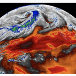
Likelihood of greater activity rises due to record-warm sea surface temperatures

Filed Under: Environment Tagged With: NOAA

University of Hawaii, NOAA to gather climate change data following Mauna Loa eruption

December 30, 2022 By GISuser

NOAA will partner with the University of Hawaii (UH) to collect atmospheric measurements at the Maunakea Observatoriesoffsite link on the Big Island of Hawaii. These measurements will provide records of global carbon dioxide (CO2) similar to those gathered for more than six decades at NOAA’s Mauna Loa Observatory (MLO), and will provide key information to track global climate change.

Filed Under: Environment Tagged With: NOAA

NOAA still expects above-normal Atlantic hurricane season

August 9, 2022 By GISuser

Preparedness is key during the peak months of hurricane season

Filed Under: Around the Web, Environment, Top Text Lead Story Tagged With: hurricane, NOAA, Weather

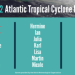
NOAA predicts above-normal 2022 Atlantic Hurricane Season

May 24, 2022 By GISuser

Ongoing La Niña, above-average Atlantic temperatures set the stage for busy season ahead

Filed Under: Earth Imaging - Remote Sensing, Environment, Research, Top Text Lead Story Tagged With: hurricane, NOAA

L3Harris High-Resolution Weather Instrument Set to Launch March 1 on NOAA’s GOES-T Satellite

February 23, 2022 By GISuser

Atmospheric river flowing across the northern Pacific Ocean captured by L3Harris’ Advanced Baseline Imager onboard the GOES-West satellite. Credit: CIRA/NOAA

MELBOURNE, Fla.–L3Harris Technologies’ (NYSE:LHX) third high-resolution weather instrument is set to launch March 1 onboard a NOAA satellite – strengthening the nation’s ability to monitor the environment and rapidly detect severe weather.

Filed Under: Earth Imaging - Remote Sensing, Emergency Response Tagged With: NOAA

Fugro helps NOAA update nautical charts in Alaska for improved maritime safety and commerce

August 6, 2021 By GISuser

Fugro has completed fieldwork on a hydrographic survey project for the US National Oceanic and Atmospheric Administration (NOAA) to update nautical charts off the northern coast of Unimak Island, Alaska. Located in the Bering Sea, the island supports multiple fisheries, a major transit route, and at‑sea cargo transfers.

Filed Under: Business, DATA Tagged With: NOAA

NOAA predicts another active Atlantic hurricane season

May 31, 2021 By Editor

May 20, 2021  – NOAA’s Climate Prediction Center is predicting another above-normal Atlantic hurricane season. Forecasters predict a 60% chance of an above-normal season, a 30% chance of a near-normal season, and a 10% chance of a below-normal season. However, experts do not anticipate the historic level of storm activity seen in 2020.

Filed Under: Emergency Response, Environment, Top Press Tagged With: hurricane, NOAA

NOAA scientists use drones to see tornado damage in remote areas

May 31, 2021 By Editor

NOAA UAV

After deadly tornadoes struck the Southeast in March, NOAA researchers for the first time successfully captured aerial photos and video of storm damage from hard-to-reach locations using remote-controlled, uncrewed aircraft.

Filed Under: Business, Environment, UAV/UAS Tagged With: drone, NOAA, UAV

TCarta Delivers Satellite-Derived Bathymetry to NOAA for U.S. Coastal Mapping Pilot

May 3, 2021 By Editor

2m SDB in Nantucket Sound, MA, produced using WorldView satellite imagery with ICESat-2 tracks overlaid.

Validated with ICESat-2 Laser Data

Filed Under: Business, Earth Imaging - Remote Sensing Tagged With: Coastal Mapping, NOAA, TCarta

Next Page »

Recent Industry News

Aerial Surveys Int’l and Global Marketing Insights to Present GEOINT 2026 Workshop on Multi-Domain Geospatial Fusion for Automated Infrastructure Monitoring

April 24, 2026 By GISuser

Why Timing Matters More Than You Think With Spray Seal (And Why People Often Get It Slightly Wrong)

April 22, 2026 By GISuser

The Quiet Planning Stage Most People Don’t See When Building a Pool in Brisbane

April 22, 2026 By GISuser

Best Equipment Labels for Industrial Use: Ranked Systems That Survive Real-World Conditions

April 17, 2026 By GISuser

Hot News

State of Data Science Report – AI and Open Source at Work

HERE and AWS Collaborate on New HERE AI Mapping Solutions

Virtual Surveyor Adds Productivity Tools to Mid-Level Smart Drone Surveying Software Plan

Categories

Copyright gletham Communications 2015 - 2026

Go to mobile version