Skytec users now have easy, on-demand tasking access to BlackSky’s hourly, high resolution satellite imagery for natural resource management
Maxar satellite imagery: Second cemetery in Mariupol area identified with new excavations
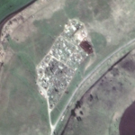
Recent Maxar high-resolution satellite imagery of the Mariupol area reveals the existence of a second cemetery that has expanded over the past month and includes several long trenches that are/will likely become new grave sites.
Aerial vs. Satellite: How to Choose the Best Imagery Type
Remote sensing methods are methods of studying the Earth and other space bodies from air or spacecraft with the help of aerial photography and satellite imagery. Satellite and aerial imagery help explore landscapes, analyze the scale of human impact on the environment, and find inspiration in the mesmerizing textures, shapes, and patterns on the planet’s […]
Satellite Imagery: Galwan Valley and Disputed India-China Border

Maxar Technologies collected new high-resolution satellite imagery yesterday (June 22nd) of the disputed Galwan Valley and the Line of Actual Control (LAC) between India and China. In the recent imagery, personnel are actively working with earth moving equipment on the dirt road that approaches the forward position (known as Patrol Point 14) near the LAC […]
Satellite Imagery: George Floyd Funeral Service – Houston, TX
Maxar Technologies collected satellite imagery today over Houston, Texas, that included the Fountain of Praise church, where the funeral service for George Floyd was being held beginning at noon. The satellite imagery was collected at 11:51 AM CDT—approximately 9 minutes before the service began.
Soar.Earth to give away free 50cm high-res SuperView satellite imagery

To celebrate the launch of SuperView on Soar, we’re giving away FREE high-res 50cm satellite imagery (normally $6/sq km) to the first 50 people who place a SuperView archive image order.
Satellite Imagery: Washington, DC and Black Lives Matter Street Mural

Maxar collected new satellite imagery this afternoon of Washington D.C. at 12:08 PM EDT that shows people gathered near the entrance to Lafayette Square and at the steps to the Lincoln Memorial.
European Satellite Navigation Competition – Extended Submission Phase
The submission phase for the ESNC 2016 is going into extra time. Interested participants have the chance to submit, complete or improve their ideas until 09:00 am (CEST) Monday, 11 July 2016 at www.esnc.eu.
Proteus strengthens their Professional Satellite Imagery Procurement Service
Proteus Geo – Press Release, 17th November 2015 – Proteus, a provider of satellite derived mapping, bathymetry and geospatial products, announce they have strengthened their Professional Satellite Imagery Procurement Service by signing up as a reseller with international satellite imagery provider Airbus Defence and Space. Proteus are now an official reseller of Airbus’s satellite imagery data and […]
Satellite Sees Smoky Skies Over World Cup Soccer – Fire and Smoke Cover SW British Columbia
This update comes via NASA / MODIS… Soccer fever gripped the U.S. at the same time as the smoke from Canadian wildfires gripped the skies over Vancouver, British Columbia.