Surveying has always been a cornerstone of construction, engineering, and land development, evolving alongside advancements in technology. Today, data collectors stand at the forefront of this transformation, enabling surveyors to gather, process, and analyze information with unprecedented speed and precision.
Virtual Surveyor Adds Productivity Tools to Mid-Level Smart Drone Surveying Software Plan

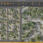
Create Surveys Faster at the Same Cost
Leica Geosystems launches GKP100 Captivate Keypad for flexible surveying
Leica Geosystems, part of Hexagon, has introduced the new Leica GKP100, a lightweight keypad that can be used with any tablet. This detachable keypad, when paired with a tablet, offers users the best of both worlds: the practicality, efficiency, and simplicity of a physical keyboard with the performance and speed of a tablet.
Virtual Surveyor Adds Planimetric Survey Functionality to Latest Release of Smart Drone Surveying Software

Faster Overall Workflow
Virtual Surveyor Unveils Photogrammetry App in Major New Release of Smart Drone Survey Software
Seamless Drone Surveying Workflow
Atwell enters into a definitive agreement to acquire Dempsey Surveying Company, expanding presence in Midwest
SOUTHFIELD, Mich.–(BUSINESS WIRE)–Atwell has entered into a definitive agreement to acquire Dempsey Surveying Company, a land surveying firm based in Cleveland, Ohio. This acquisition, the third transaction announced by Atwell this quarter, will expand the company’s presence in Ohio and surveying capabilities in the Midwest. The deal is expected to close by Dec. 31, 2022.
Spectra Geospatial Introduces Next Generation of Field Solutions for Survey Professionals

Westminster, Colo., June 8, 2021—Spectra Geospatial introduced today the Spectra® Geospatial Origin software and the new Ranger 5 Data Collector, a powerful field software and hardware combination designed to equip surveying professionals with innovative and intuitive field tools needed to increase productivity and efficiency.
Trimble Business Center version 5.40 Allows Users to Start and Stay in One Office Software

Trimble Business Center Streamlines Point Cloud Workflows and Adds Vertical Applications Enabling Survey and Mapping Professionals to Maximize Productivity
Virtual Surveyor Drone Surveying Software Simplifies Workflow for Earthworks Monitoring at Construction Sites

Fast Cut-and-Fill Calculations
Virginia Surveyors Name Dr. Gladys West Honorary Member
Recognized for Mathematical Modeling that Led to GPS