GISuser.com

GIS and Technology news for mapping professionals

  • PRESS
    • Submit PR
    • Top Press
    • Business
    • GIS, Geo Tech Software
    • Hardware
    • UAV News
    • Mobile Technology
    • Editor’s Top Picks
    • Get TOP Listing!
  • FEATURES
    • GeoGeeksinCars
    • 10 Question Q&A
    • FROM THE EDITOR
    • SPATIAL MEDIA AUTHORS
    • Social Media Features
    • EXPERTS & Guests
    • Listicles and Top 10 Lists
    • Infographics
    • VIDEOS
  • Events
    • Webinars
    • Submit event
    • Event Media Partner
  • CAREERS
    • Career Help Articles
    • People and Career News
    • Work from Home
    • About GeoJobs.BIZ
  • About
    • Advertise
      • Advertise wth GISuser
      • Media Kit Request Form
      • Directory
      • Submit Press
    • Contact GISuser
    • Meet the Editor
    • Social Media
      • AnyGeo Blog
      • GeoGeeks Podcast
      • Social Media Features
      • Like Us
    • SpatialMedia
      • LBSzone
      • LiDAR Magazine
      • Amerisurv
      • SymbianOne
    • RSS feed
  • Blog
  • Shop
  • Cloud Hosting
    • Amazon Cloud Hosting
    • WordPress cloud hosting
    • Dedicated servers USA
    • Linux Shared Hosting
    • Windows Shared Hosting
    • Web Development
    • SSL Certificate
  • Tradepubs
You are here: Home / Archives for *FEATURES / THE EDITOR

Beulr – The Bot that Attends Zoom Meeting on your Behalf!

October 22, 2020 By Editor

Beulr

This just might possibly be the BEST App name EVER!! Note, according to the developers, Beulr is not recommended for zoom meetings that might require you to be interactive with others.

Filed Under: Around the Web, Business, THE EDITOR, Tips, Top Press Tagged With: Zoom

Mapping the Spread of #Coronavirus COVID-19 – Trusted Maps and Data

March 5, 2020 By GISuser

HERE Developer tracking Coronavirus COVID-19

This post has generated loads of activity and engagement via LinkedIn. The article discusses the coronavirus outbreak and delves into a look at some trusted map and data resources that are tracking the spread.

Filed Under: Around the Web, Emergency Response, THE EDITOR, Top Text Lead Story, Web Services Tagged With: coronavirus, covid19, health, Maps, opendata, webmaps

New Functionality in ArcGIS Online, Story Maps and Data Collection Shared at ESRIUC

July 29, 2019 By Editor

The annual International Esri User Conference is ESRI’s chance to discuss, demonstrate, and showcase their latest technologies and educate the user community about all the latest innovations from their product design teams. 

Filed Under: Software, THE EDITOR, Top Press Tagged With: arcgis, arcgis online, esriuc

Rapid Data Collection in ArcGIS Gets Quick with ArcGIS QuickCapture

July 26, 2019 By Editor

ArcGIS QuickCapture

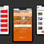
ESRIUC has come and gone (20 in a row for yours truly) and like many of you, I found I returned home feeling invigorated, enthusiastic, and eager to try some new things and explore technologies I was recently introduced to. One such technology is ArcGIS QuickCapture.

Filed Under: Mobile, THE EDITOR, Top Press Tagged With: arcgis, Data, data capture, ESRI

GISuser Awareness Promotion for #ESRIUC Exhibitors

May 28, 2019 By GISuser

Summer is here, and that means time for the International Esri User Conference (ESRIUC)! With that, we are pleased to announce a special promotional opportunity to help you share your plans for UC. Ideally, this is the perfect opportunity to share the WHO, WHAT, WHERE, WHEN, WHY, and HOW of your plans to potential users and […]

Filed Under: THE EDITOR Tagged With: esriuc

5 Resources to help kickstart your Geotech or Location Technology Startup

April 12, 2019 By GISuser

startup tips

Getting your business off the ground can be a huge challenge. For technology start-ups though, there’s many valuable resources that you can tap into. There’s incubators, startup labs, hackathons, developer programs, and many more opportunities that exist. Here, I quickly touch upon 5 handy resources that a Geotech startup can leverage to get a boost.

Filed Under: Developer, THE EDITOR, Top Press, Top Text Lead Story Tagged With: developer, startup

Creating Story Maps Just Got Easier with the New Look, ArcGIS StoryMaps Beta

April 10, 2019 By GISuser

arcgis story maps Beta

Do you enjoy creating Story Maps? If so, there’s something new for you to explore, the Story Maps Beta. The new, Beta resource offers a completely new experience, new UI and new look and feel of your maps.

Filed Under: Map of the Day, Maps and Cartography, Software, THE EDITOR, Top Text Lead Story Tagged With: arcgis, arcgis online, ESRI, story maps

GeoGeeksinCars #31 Glenn’s Announcement at the 2019 Esri DevSummit

April 9, 2019 By GISuser

geogeeksincars

“The one about Glenn’s plans” – March, 2019 in Palm Springs, CA at the 2019 Esri DevSummit. On the final day, after a busy week at EPC and DevSummit, Glenn rolled solo on the way back to the Geo Pad and talked about gletham Communications.

Filed Under: Business, GeoGeeksinCars, THE EDITOR, video, VIDEOS Tagged With: devsummit, geogeeksincars, Video

[WOW Tech] Seen and Heard at #ESRIUC – the new Echosec ArcGIS Integration

July 7, 2016 By Editor

echosec team

If you were in attendance at the 2016 ESRIUC then you likely heard about a little company in the Esri Startup Pavillion called Echosec. Now in year 3 as an esri small business partner, Echosec used the UC as a coming out party to announce their integration with ArcGIS Online

Filed Under: 2016 ESRIUC, Business, THE EDITOR, Top Press Tagged With: arcgis, echosec, search, Security

5 Must Have Mobile Apps While You visit San Diego for #esriuc

June 22, 2016 By Editor

Here we are once again on the heels of another International Esri User Conference #esriuc. This means that geeks and GeoGeeks from all over the World (over 150 countries I’m guessing) will be converging on the city for the annual Geo Luv-fest. 

Filed Under: *FEATURES, 2016 ESRIUC, Business, ESRIUC, Features of the Month, Mobile, THE EDITOR, Tips, Top Press Tagged With: esriuc, mobile apps, mobile maps

Next Page »

Connect with GISuser

  • Facebook
  • Google+
  • LinkedIn
  • RSS
  • Twitter


GIS jobs

Recent Features

Digitalization and Simulation at the North Pole

Natural Gas District & GIS-Centric Asset Management

5 Ways Technology Is Affecting The Sharing Economy

Spotlight – Township Canada: Explore Canadian Legal Land Descriptions on a Map

GeoGeeksinCars – The one in “Tippy” the right-hand drive Mitsubishi, at DevSummit

More Posts from this Category

Categories


Recent Posts

  • Best Gaming Phones for 2021
  • Everything You Need to Know About Selling on Amazon
  • Trimble Announces Rugged, Lightweight Field Data Controller for Land and Construction Surveying
  • Webinar – How to Solve Algal Blooms in Municipal Water
  • Concept3D Offers Virtual Tour and Mapping Software to Hospitality and Tourism Industry at No Cost

RSS Career Tips

  • Four Characteristics of the Best Virtual Employees
  • Jobcase Launches Free Unemployment Resource Center for Workers Impacted by COVID-19
  • 8 Questions Employers Should Ask About Coronavirus
  • Must-Have Gadgets and Technology for the Remote Office Worker
  • Must-Have Gadgets and Technology for the Remote Office Worker


shop for geogeek swag

RSS Tech pubs

  • The Human Resources Management Kit - 2021 Edition
  • The Essentials for CEOs - 2021 Kit
  • The Essentials of Cloud - 2021 Kit

RSS Computers

  • iPad CTO Kit - including the iPad Tips and Tricks Guide for IT Executives and Managers
  • The Essentials of Information Security Kit: Includes a Free PC Security Handbook - 2nd Edition eBook
  • Windows... On Speed

RSS HR Tips

  • The Human Resources Management Kit - 2021 Edition
  • A Better Alternative to the Antiquated EAPs
  • The Mental Health Pandemic: 2021's Top Employer Trend

RSS Gov Tech

  • Cyberwarfare Requires Speed, Adaptability and Visibility to Win: Enterprises Must Close the IT Operations and Security Gap
  • The New American Workplace Research Kit - Includes a Free $8.50 Book Summary
  • Next-generation Situational Awareness - How Skydio's autonomous drone solutions protect first responders

RSS UAV news

  • Global Commercial Drone Market Expected to Exceed $8.5 Billion By 2027
  • Down to Earth – Drone Lidar Surveying Reality Series Returns
  • Florida Signs Participating Addendum with DroneUp Providing Public Sector Agencies Access to Drone Services

RSS Geojobs

  • An error has occurred, which probably means the feed is down. Try again later.
Copyright Spatial Media LLC 2003 - 2015