GIS user technology news

News, Business, AI, Technology, IOS, Android, Google, Mobile, GIS, Crypto Currency, Economics

  • Advertising & Sponsored Posts
    • Advertising & Sponsored Posts
    • Submit Press
  • PRESS
    • Submit PR
    • Top Press
    • Business
    • Software
    • Hardware
    • UAV News
    • Mobile Technology
  • FEATURES
    • Around the Web
    • Social Media Features
    • EXPERTS & Guests
    • Tips
    • Infographics
  • Blog
  • Events
  • Shop
  • Tradepubs
  • CAREERS
You are here: Home / Archives for data capture

SSP Innovations Announces Production Release of SSP Vision, Revolutionary New Field Data Capture Product

April 7, 2023 By GISuser

DENVER–(BUSINESS WIRE)–SSP Innovations, LLC (SSP) today announces the production release of SSP Vision, a revolutionary new field data capture product for utilities, telecommunications companies and any organization that manages geographically distributed assets.

Filed Under: Business, Software Tagged With: data capture, ssp

Rapid Data Collection in ArcGIS Gets Quick with ArcGIS QuickCapture

July 26, 2019 By Editor

ArcGIS QuickCapture

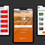
ESRIUC has come and gone (20 in a row for yours truly) and like many of you, I found I returned home feeling invigorated, enthusiastic, and eager to try some new things and explore technologies I was recently introduced to. One such technology is ArcGIS QuickCapture.

Filed Under: Mobile, THE EDITOR, Top Press Tagged With: arcgis, Data, data capture, ESRI

Recent Industry News

Top Benefits of AI Video Surveillance for Businesses and Public Spaces

June 5, 2026 By GISuser

How to Choose the Best Office Interior Designers in Delhi for End-to-End Projects

June 3, 2026 By GISuser

Why Bathroom Renovation Services Often Change More Than Just the Bathroom

May 20, 2026 By GISuser

The Drift Between Early Notes and Final Case Files in Abuse-Related Legal Support

April 29, 2026 By GISuser

Hot News

State of Data Science Report – AI and Open Source at Work

HERE and AWS Collaborate on New HERE AI Mapping Solutions

Virtual Surveyor Adds Productivity Tools to Mid-Level Smart Drone Surveying Software Plan

Categories

Copyright gletham Communications 2015 - 2026

Go to mobile version