This post has generated loads of activity and engagement via LinkedIn. The article discusses the coronavirus outbreak and delves into a look at some trusted map and data resources that are tracking the spread.

HERE Developer tracking Coronavirus COVID-19
Well, here we are in the middle of what appears to be a looming, global pandemic. So, where are you getting your information from? Perhaps more important, what maps, webmaps, and web data (WMS) portals are you consulting for information and updates? There are many outlets, both official and unofficial that are sharing regular updates, however, be sure to ask yourself can these data be trusted? The following are a few resources to consider:
Mapping the novel coronavirus outbreak (StoryMap)
This Story Map from the Esri team brings together a number of resources that the team monitors and has selected as being trusted. According to the Story, the data, charts, and maps are updated daily and a number of descriptive aids are shared for the reader, for example, a detailed comparison of this outbreak to SARS and MERS. Read on in this StoryMap to learn the history of the outbreak and trace the spread over time.

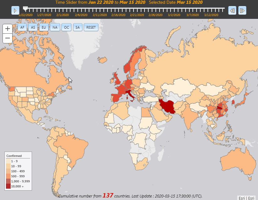
CoronaVirus COVID-19 Dashboard, by Johns Hopkins
This impressive Dashboard put together by the team at John’s Hopkins has become a defacto go-to resource for many popular media outlets, and for good reason. The dashboard tracks cases around the World, sharing maps, tables, and an interactive dashboard pulling data that is constantly updated. You have to consult this resource!


This “Hub” was stood up by Esri (I’m assuming it was the Esri Public Health Team) and is also a place where institutions and organizations needing to map, analyze, and share data can get in touch with the Esri team for assistance. This is also a gateway to other maps and apps that Esri partners and customers are deploying. Numerous StoryMaps, featured data products, and regional applications are available here – this is definitely a resource for local government agencies to consult (PS: You may want to keep an eye on King County, WA)

CDC, official Coronavirus COVID-19 Page – This page is updated once a day, on weekdays, and shares US nationwide data and updates on the rate of spread. Tables show a running count of reported cases along with a count of the suspected source if is believed to have come from outside the USA. A Global map is provided along with related weblinks and links to tips and help resources – overall though, there’s not much here. Sadly, in this time of political “instability” and divisiveness, many are suspect or not trusting even these official Government sources – I’ll leave it up to you to decide for yourself!
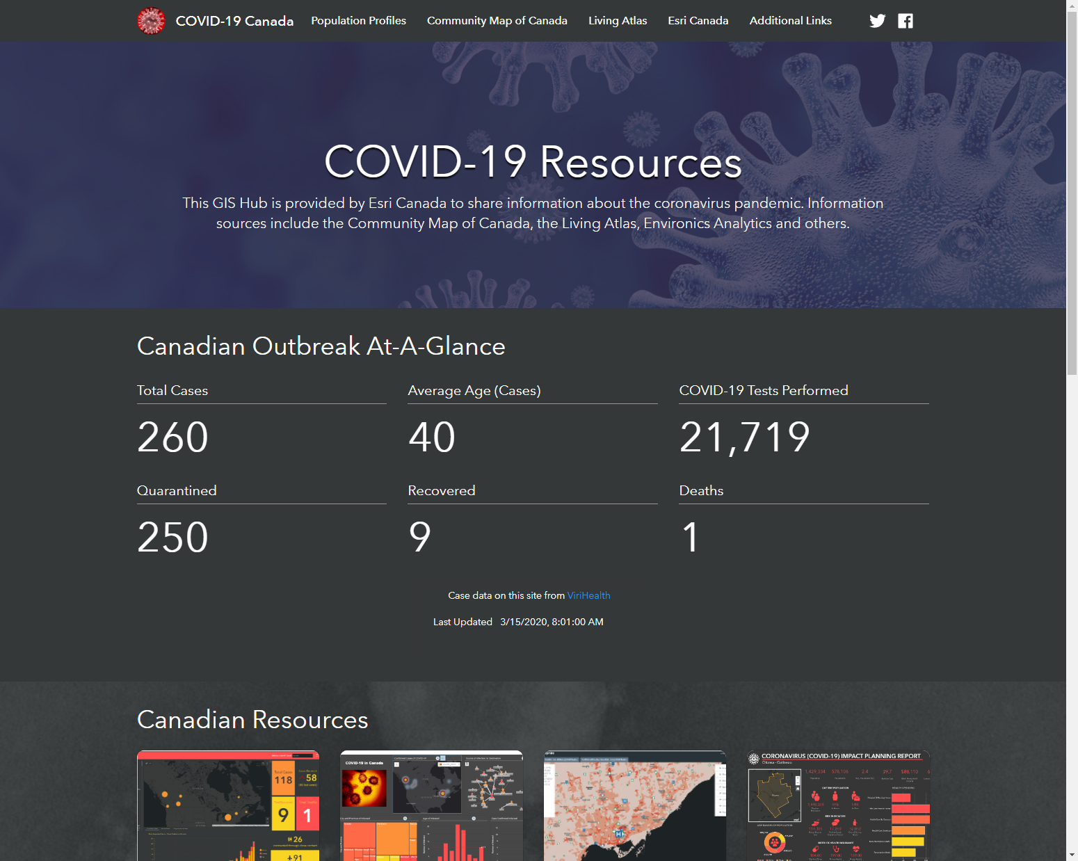
COVID-19 Canada Hub – @esricanada Has stood up a #COVIDー19 hub to provide citizens with the latest data, maps & information. Local government are encouraged to connect with them to consider deploying their own local or regional information hub
WHO Health Emergency Dashboard – The World Health Organization (WHO) Health Emergency Dashboard is a platform which aims to share information about public health events and emergencies. The data on the dashboard is refreshed every fifteen (15) minutes and data is accurate as at time of refreshing. The events displayed are a subset of those reported through official channels as mandated by the International Health Regulations (IHR 2005). The content of the WHO Health Emergency Dashboard is for general information only

University of Virgina COVID-19 Surveillance Dashboard – Impressive dashboard monitoring active, confirmed, recovered, and deaths from coronavirus. Be sure to also run the time series slider!

COVID-19 Surveillance Dashboard
U Virgina, COVID-19 Surveillance Dashboard
As new resources pop up or I receive tips, they will be added here.
HERE Developer tracking Coronavirus COVID-19 – This resource from HERE is sharing data from Johns Hopkins and others to provide a nice map interface (using vector tiles) and provides a running tabular list of reported cases by country and city.
Data from DXY (China) – Running data counts from China with detailed breakdown by region and city. Note, the site also translates to English when using on mobile.
Tracking coronavirus cases in the UK – This dashboard tracks the spread of the virus in the UK – from Public Health England
Create a State-wide Coronavirus (COVID-19) Infographic – States and other agencies are encouraged to create a regional dashboard to share current information, maps, data and more. This article from Esri shares everthing the State GIS manager needs
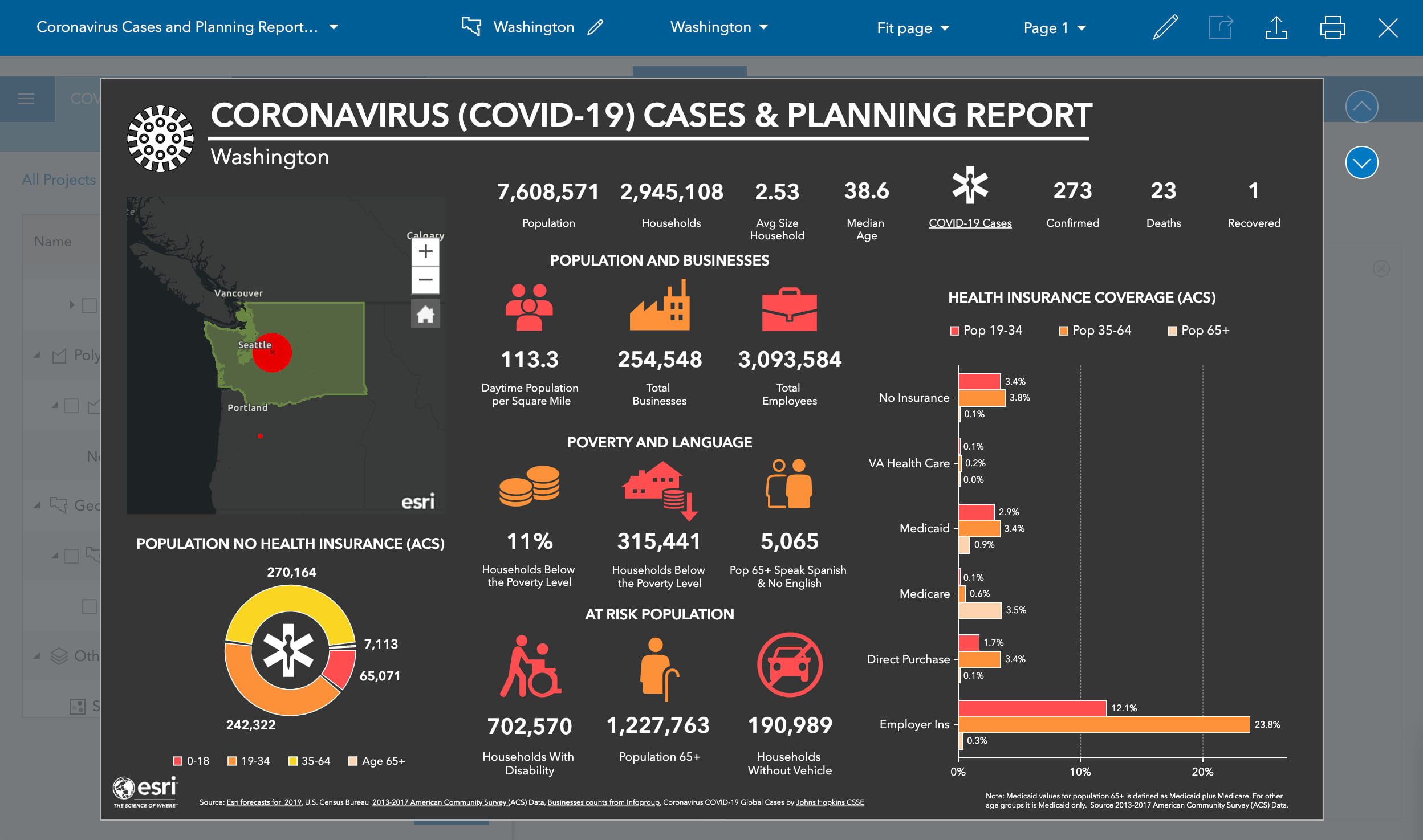
Create State-wide Coronavirus (COVID-19) Infographic
SafetyDetectives – live updates from 199 countries
You can keep track of the rate of infection using this live tracker.
Coronavirus News Dashboard – This dashboard from Esri Germany continues to update every 15 minutes with the latest Coronavirus related news announcements of interest in Europe.
– In addition to the online map, the developers have created a slideshow that walks you through the spread of the coronavirus in America. See the slideshow of how the virus spreads day-by-day across the USA – data from Johns Hopkins
Note, details of this blog post were shared on the GISuser LinkedIn group and have generated much discussion. See HERE
Other suggested Coronavirus COVID-19 Resources:
- CDC
- World Health Organization COVID-19 Advice
- Infoweek – Fighting CoronaVirus with GIS
- Seattle Times update, March 4
Submit a tip
Esri has resources to help your community respond to #COVID19. Learn how to build dashboards, story maps, mobile apps, and more: https://t.co/cvyU2fMo30 #PublicHealth pic.twitter.com/xCYtE1032L
— Esri (@Esri) March 16, 2020