GIS user technology news

News, Business, AI, Technology, IOS, Android, Google, Mobile, GIS, Crypto Currency, Economics

  • Advertising & Sponsored Posts
    • Advertising & Sponsored Posts
    • Submit Press
  • PRESS
    • Submit PR
    • Top Press
    • Business
    • Software
    • Hardware
    • UAV News
    • Mobile Technology
  • FEATURES
    • Around the Web
    • Social Media Features
    • EXPERTS & Guests
    • Tips
    • Infographics
  • Around the Web
  • Events
  • Shop
  • Tradepubs
  • CAREERS
You are here: Home / Archives for hurricane

Satellite Imagery: Hurricane Michael Aftermath in Mexico Beach, Florida

October 15, 2018 By GISuser

The Maxar News Bureau has released satellite images that DigitalGlobe collected October 12th over Mexico Beach and Panama City, Florida. Today’s imagery shows the incredible power of Hurricane Michael, with numerous homes literally ripped away from their foundations and many other structures that have been completely demolished or are missing altogether.

Filed Under: Earth Imaging - Remote Sensing, Top Press Tagged With: Florida, hurricane

Forecasters predict a near- or above-normal 2018 Atlantic hurricane season

May 24, 2018 By GISuser

above-normal 2018 Atlantic hurricane season

NOAA’s Climate Prediction Center is forecasting a 75-percent chance that the 2018 Atlantic hurricane season will be near- or above-normal.

Filed Under: Environment, Top Press Tagged With: hurricane

Satellite Imagery Aids Rescue Efforts for Hurricanes Harvey, Irma and Maria

November 20, 2017 By Editor

Free and rapid imagery was provided through the USGS Hazard Data Distribution System The calls for assistance started days before Hurricane Harvey came barreling across America’s doorstep this summer. First responders and government officials needed answers to prepare and protect communities. How strong is this storm going to be? What kind of damage occurred on […]

Filed Under: Earth Imaging - Remote Sensing, Emergency Response Tagged With: hurricane, Imagery

Hurricane Irma Emergency Response WebMaps

September 8, 2017 By GISuser

hurricane Irma

There’s many maps, webmaps and web resources available online to support the response to Hurricane Irma. These range for traffic maps, evacuation routes, shelter locations, wind speed and direction information and much more. The following is a sample of some map resources that have been compiled by the crew at GEO Jobe

Filed Under: Emergency Response, Maps and Cartography Tagged With: hurricane, irma, Maps

Companies from the GIS & GeoTech Community Providing Emergency Response & Relief? {form}

September 8, 2017 By GISuser

Many companies and people from the GIS, mapping, surveying, and geotech community have sprung into action to help with the response and relief effort from recent disasters. If you or your company (or one you know of) have provided resources or are willing to provide resources to help, please provide details here. Note: in addition […]

Filed Under: Emergency Response, Environment, Top Press Tagged With: hurricane, response

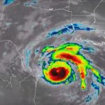
NASA Sees Irma Strengthen to a Category 5 Hurricane

September 5, 2017 By GISuser

NASA and NOAA satellites have been providing valuable satellite imagery to forecasters at the National Hurricane Center, and revealed that Hurricane Irma has strengthened to a Category 5 hurricane on Sept. 5 around 8 a.m. EDT (1200 UTC).

Filed Under: Earth Imaging - Remote Sensing, Environment, Top Press Tagged With: hurricane, NASA

Rains to From Tropical Storm Harvey Continue over Texas, Louisiana

August 28, 2017 By GISuser

This infrared imagery from GOES-16 shows Tropical Storm Harvey earlier this morning, Monday, August 28, 2017.

Filed Under: Environment Tagged With: harvey, hurricane, NOAA, Texas

NOAA Satellite Imagery of Hurricane Harvey

August 28, 2017 By GISuser

hurricane harvey

Watch Harvey’s Movements from the Evening of August 24 to Noon on August 28

Filed Under: Environment, Top Press Tagged With: harvey, hurricane, Texas

Flood Resource – USGS Flood Event Viewer (FEV) #Hurricane #Harvey

August 27, 2017 By GISuser

FEV (an interactive map) provides viewable and downloadable flood event data

Filed Under: Emergency Response, Environment, Top Text Lead Story Tagged With: harvey, hurricane, USGS

USGS – Many Texas Beaches Likely to Erode, Be Overwashed, or Inundated by Hurricane Harvey

August 27, 2017 By GISuser

To learn more about USGS’ role providing science to decision makers before, during and after Hurricane Harvey, visit the USGS Hurricane Harvey page. UPDATE: This story has been revised to reflect new NOAA-National Hurricane Center storm surge projections which were released August 25 at 7 a.m.

Filed Under: Emergency Response Tagged With: harvey, hurricane, USGS

« Previous Page
Next Page »

Recent Posts

  • Beyond the Gap: Maximizing Your ROI with a Strategic Bridging Loan
  • EzRemove’s Background Remover vs Transparent Background Maker — AI Tools for Effortless Image Editing in 2025
  • Top Luxury Tours in Ghana for a Unique Travel Experience
  • How to Monitor Performance of GIS and Mapping Apps Across Different Regions and Network Conditions
  • 5 Compliance Risks Your EMR Audit Tool Can Catch Before an External Audit
  • Apartment Movers in Abu Dhabi | Reliable Moving Services
  • 11 Best Ways to Farm Rare Brainrots in Steal a Brainrot
  • Navigating the Digital Casino: A Modern Guide to Security and Responsibility in Online Slots
  • Decode the Hidden Value of Your Old Vehicle and Turn It from Scrap to Cash
  • 8 Live Dealer Game Formats You’ll Find in Malaysia

Recent Features

Space Flight Laboratory (SFL) Announces Successful Launch & Deployment of HawkEye 360’s Cluster 11

FOSS4G NA 2024: The Premier Open Source Geospatial Conference Returns to St. Louis, September 9-11

Photographer Touch Reveal the Top Cameras, Lenses, and Photo Editing Tools of 2022

Digitalization and Simulation at the North Pole

Natural Gas District & GIS-Centric Asset Management

More Posts from this Category

Categories

RSS Career Tips

  • Four Characteristics of the Best Virtual Employees
  • 28 Tools to Conquer the Social Media Recruiting World
  • 8 Questions Employers Should Ask About Coronavirus
  • Jobcase Launches Free Unemployment Resource Center for Workers Impacted by COVID-19
  • Must-Have Gadgets and Technology for the Remote Office Worker


featured podcast

RSS Tech pubs

  • The Insider Threat Guide: Detection and Protection Strategies with Modern IAM
  • The Ultimate Guide to Online Fraud Prevention
  • Inkjet for All!

RSS Computers

  • How the Cloud is Reshaping Virtual Desktops
  • Millennials as Brand Advocates - New Research Study Results
  • Vehicles Best Practices Installation Guide

RSS HR Tips

  • AWS GovCloud (US) Celebrates 10th Anniversary and a Decade of Digital Transformation in the Federal Government
  • Exploring the Impact of COVID-19 on Customer Behavior
  • The Pivot to 100% Remote Training in the Contact Center

RSS Gov Tech

  • 10 Legal Jobs You Can Get Without a Law Degree
  • J.D. Power Examines How the Inflation Reduction Act Reshapes EV Landscape
  • Making Telehealth Work for You: The Ultimate Guide

Copyright Spatial Media LLC 2003 - 2015

Go to mobile version