GIS user technology news

News, Business, AI, Technology, IOS, Android, Google, Mobile, GIS, Crypto Currency, Economics

  • Advertising & Sponsored Posts
    • Advertising & Sponsored Posts
    • Submit Press
  • PRESS
    • Submit PR
    • Top Press
    • Business
    • Software
    • Hardware
    • UAV News
    • Mobile Technology
  • FEATURES
    • Around the Web
    • Social Media Features
    • EXPERTS & Guests
    • Tips
    • Infographics
  • Blog
  • Events
  • Shop
  • Tradepubs
  • CAREERS
You are here: Home / Archives for hurricane

Record-breaking Atlantic hurricane season draws to an end

November 26, 2020 By Editor

NOAA hurricane

Improved forecasts, extensive preparedness helped protect lives and property

Filed Under: Emergency Response, Environment, Top Text Lead Story Tagged With: hurricane, NOAA

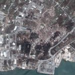
Satellite Imagery: Aftermath of Hurricane Iota in Providencia Island, Colombia @Maxar

November 22, 2020 By Editor

Maxar Technologies collected new satellite imagery yesterday (November 21st) of the small Colombian island of Providencia, which suffered extreme damage from Hurricane Iota. Nearly all of the island’s infrastructure was destroyed from the powerful category 5 storm that struck the island on November 16th

Filed Under: Earth Imaging - Remote Sensing, Emergency Response, Featured TOP PR Tagged With: hurricane, Imagery, maxar

National Geodetic Survey damage assessment imagery from Hurricane Sally available online

September 30, 2020 By Editor

National Geodetic Survey damage assessment imagery available online.

Filed Under: Business, Earth Imaging - Remote Sensing, Emergency Response, Top Text Lead Story Tagged With: hurricane

Satellite Imagery: Hurricane Sally Damage & Aftermath, Alabama

September 18, 2020 By Editor

Yesterday (September 17), in between the clouds, Maxar Technologies’ WorldView-3 satellite collected new satellite imagery of the aftermath of Hurricane Sally that reveals damage to many homes, businesses and infrastructure along the Alabama Gulf coast.

Filed Under: Earth Imaging - Remote Sensing, Emergency Response, Top Text Lead Story Tagged With: alabama, hurricane, Imagery, sally, satellite

Portsmouth scientists help cyclone disaster response in coronavirus-hit Pacific

April 27, 2020 By GISuser

Path of destruction: Satellite imagery shows the path of Cyclone Harold from the Solomon Islands on April 2, to Vanuatu on April 6 and on to Fiji on April 8 (source: UNITAR/UNOSAT)

Researchers followed hot on the heels of a major cyclone that hit a Pacific island during the coronavirus pandemic, mapping the damage within hours.

Filed Under: Emergency Response, Environment, Top Text Lead Story Tagged With: cyclone, fiji, hurricane, Imagery

Satellite Imagery: Hurricane Dorian Damage in the Bahamas

September 6, 2019 By GISuser

downtown marsh harbour_great abaco island_after hurricane

Maxar collected new satellite imagery this morning (September 5th) over the northern Bahamas that provide our first clear view of the extensive damage caused by Hurricane Dorian to Marsh Harbour, Great Abaco Island and a number of the villages on nearby cays.

Filed Under: Earth Imaging - Remote Sensing, Emergency Response, Environment Tagged With: hurricane, maxar

USGS deploying 175 storm-tide sensors in Fla., Ga.

September 6, 2019 By GISuser

As Hurricane Dorian gets closer to Florida, U.S. Geological Survey scientists have been in the field from Savannah, Georgia to Hollywood, Florida and on Florida’s Gulf Coast, deploying 175 storm-tide sensors [video] and16 other instruments that will track the hurricane’s effects.

Filed Under: Environment Tagged With: hurricane

NOAA increases chance for above-normal hurricane season

August 15, 2019 By GISuser

The end of El Nino could boost Atlantic hurricane activity

Filed Under: Environment, Top Text Lead Story Tagged With: hurricane, NOAA

2019 Atlantic hurricane season expected to worsen

August 13, 2019 By GISuser

New predictions prompt C Spire to redouble efforts to maintain service in the worst conditions

Filed Under: Environment Tagged With: hurricane, NOAA

Live Location Intelligence Provides Insights into Communities in Hurricane Barry’s Path

July 10, 2019 By GISuser

This via Esri… Live Location Intelligence Provides Insights into Communities in Hurricane Barry’s Path

Filed Under: Emergency Response, Top Text Lead Story Tagged With: ESRI, hurricane, story map

« Previous Page
Next Page »

Recent Industry News

Best Equipment Labels for Industrial Use: Ranked Systems That Survive Real-World Conditions

April 17, 2026 By GISuser

Building a Global Natural Brand: The Digital Journey of VedaOils

April 15, 2026 By GISuser

DeltaQuad partners with Meridein Group OÜ to strengthen UAS capability in the Baltics

April 15, 2026 By GISuser

The Complete Guide to Improving Home Safety and Efficiency with Dryer Vent Cleaning

April 12, 2026 By GISuser

Hot News

State of Data Science Report – AI and Open Source at Work

HERE and AWS Collaborate on New HERE AI Mapping Solutions

Virtual Surveyor Adds Productivity Tools to Mid-Level Smart Drone Surveying Software Plan

Categories

Copyright gletham Communications 2015 - 2026

Go to mobile version