GISuser.com

GIS and Technology news for mapping professionals

  • PRESS
    • Submit PR
    • Top Press
    • Business
    • Software
    • Hardware
    • UAV News
    • Mobile Technology
  • FEATURES
    • Around the Web
    • Social Media Features
    • EXPERTS & Guests
    • Tips
    • Infographics
  • Events
  • CAREERS
  • Advertise
    • Advertise
  • Blog
  • Shop
  • Tradepubs
You are here: Home / Archives for Texas

Top 10 Reasons Folks are Moving to Texas

November 17, 2021 By GISuser

Jobs in Dallas, outdoor fun in Houston, artist communities in Austin – the list goes on

Filed Under: Around the Web, business, Lists Tagged With: Business, Texas

Panoramic Imagery for Canyon Gate Subdivision, Fort Bend County, Texas

September 6, 2017 By GISuser

Panoramic Imagery for Canyon Gate Subdivision, Fort Bend County, Texas

An update from Fort Bend County, Texas and their recent use of Esri Startup company, GroundVu, for obtaining 3D imagery of flood areas.

Filed Under: Earth Imaging - Remote Sensing Tagged With: flood, Panoramic Imagery, Texas

Rains to From Tropical Storm Harvey Continue over Texas, Louisiana

August 28, 2017 By GISuser

This infrared imagery from GOES-16 shows Tropical Storm Harvey earlier this morning, Monday, August 28, 2017.

Filed Under: Environment Tagged With: harvey, hurricane, NOAA, Texas

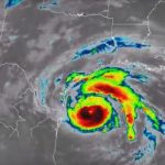
NOAA Satellite Imagery of Hurricane Harvey

August 28, 2017 By GISuser

hurricane harvey

Watch Harvey’s Movements from the Evening of August 24 to Noon on August 28

Filed Under: Environment, Top Press Tagged With: harvey, hurricane, Texas

Twitter feed and map provide real-time water, weather and flood forecasting for Texas

May 27, 2016 By GISuser

texas

(via the USGS) Flood Preparedness – There’s a New USGS Map (or App) for That — An innovative Twitter feed and map provide real-time water, weather and flood forecasting for Texas.

Filed Under: Around the Web, Environment, EXPERTS, FrontPage Leader, Top Features, Top Press Tagged With: flood, social media, Texas, USGS

Drone Survey of Seagrasses Tested for Texas Parks & Wildlife

April 25, 2016 By GISuser

Drone Survey of Seagrasses Tested for Texas Parks & Wildlife

CORPUS CHRISTI, Texas — Aerial images from a drone are being evaluated as a method to survey seagrasses scarred by boat propellers.

Filed Under: Business, Environment, UAV/UAS Tagged With: drone survey, Texas, UAV

New Maps for Texas and Oklahoma Released

April 7, 2016 By Editor

Updated US Topo maps for Texas and Oklahoma available for download; add Census Bureau road data, wetlands layer and select trails

Filed Under: DATA, Government & OpenGov, Top Press Tagged With: Data, Maps, Oklahoma, Texas, USGS

NACRC Holds Annual Conference in Houston, Texas

September 21, 2015 By GISuser

NACRC Holds Annual Conference in Houston, Texas

NACRC members, vendors and non-members gathered August 21-24 in Houston, Texas, for the 2015 Annual Conference for discussion on the latest issues affecting court administration, clerk to board, vital statistics, elections administration, land records and records management.

Filed Under: Business Tagged With: NACRC, Texas

Indiana and Texas Square off in a Civic Hackathon Challenge

January 23, 2015 By GISuser

Indiana v Texas hackathon

#hackINvTX Challenge runs from Jan. 31-Feb. 23

Filed Under: Developer, Events Tagged With: hackathon, Iniana, Texas

Texas.gov Receives 18 Awards in 2014

December 23, 2014 By GISuser

State’s official website recognized for website excellence, innovative security practices, successful marketing campaign, and more.

Filed Under: Government & OpenGov Tagged With: Texas

Next Page »

Feed

  • RSS


GIS jobs


Recent Features

Digitalization and Simulation at the North Pole

Natural Gas District & GIS-Centric Asset Management

5 Ways Technology Is Affecting The Sharing Economy

Spotlight – Township Canada: Explore Canadian Legal Land Descriptions on a Map

GeoGeeksinCars – The one in “Tippy” the right-hand drive Mitsubishi, at DevSummit

More Posts from this Category

Categories

Recent Posts

  • A treadmill is one of the most popular fitness equipment
  • 3 Things to Help You Become a Software Engineer
  • Esri Announces Winners of the 2022 ArcGIS Online Competition
  • KBC WhatsApp Lottery Winner 2022 List – KBC Head Office Number +19188444477 – KBC Sim Card Lucky Draw 2022
  • Animation explainer for a trading application

RSS Career Tips

  • Four Characteristics of the Best Virtual Employees
  • 8 Questions Employers Should Ask About Coronavirus
  • Jobcase Launches Free Unemployment Resource Center for Workers Impacted by COVID-19
  • Must-Have Gadgets and Technology for the Remote Office Worker
  • Must-Have Gadgets and Technology for the Remote Office Worker


shop for geogeek swag

RSS Tech pubs

  • Top Tips and Tricks: Windows 11
  • The 2022 State of the Data Center Report
  • What is Network Security?

RSS Computers

  • The Essentials of Information Security Kit: Includes a Free PC Security Handbook - 2nd Edition eBook
  • The Idiot's Ultimate Guide to Build Your Own PC
  • Windows... On Speed

RSS HR Tips

  • Measuring and Managing Employee Experience
  • At Work: The 2022 Workplace Trends Report
  • The 2022 Guide To Creating A Great Visitor Experience

RSS Gov Tech

  • The Bipartisan Infrastructure Bill: How you can win more bids
  • How Connected Vehicle Data Can Transform Public Sector Decision-Making
  • Getting started with personalization at scale

RSS UAV news

  • Draganfly Deploys Versatile Situational Assessment Drones to Ukraine
  • Ocean Specialists Inc. Launches “USVs as a Service” Business Line
  • UAS Drone Subsidiary, Duke Robotics’, Sniper Drone showcased at a leading International Airshow in the Asia Pacific Region

RSS Geojobs

  • IT Endpoint Lead
Copyright Spatial Media LLC 2003 - 2015