GIS user technology news

News, Business, AI, Technology, IOS, Android, Google, Mobile, GIS, Crypto Currency, Economics

  • Advertising & Sponsored Posts
    • Advertising & Sponsored Posts
    • Submit Press
  • PRESS
    • Submit PR
    • Top Press
    • Business
    • Software
    • Hardware
    • UAV News
    • Mobile Technology
  • FEATURES
    • Around the Web
    • Social Media Features
    • EXPERTS & Guests
    • Tips
    • Infographics
  • Blog
  • Events
  • Shop
  • Tradepubs
  • CAREERS
You are here: Home / * PRESS / Emergency Response / Flood Resource – USGS Flood Event Viewer (FEV) #Hurricane #Harvey

Flood Resource – USGS Flood Event Viewer (FEV) #Hurricane #Harvey

August 27, 2017 By GISuser

FEV (an interactive map) provides viewable and downloadable flood event data

hurricane harvey flood

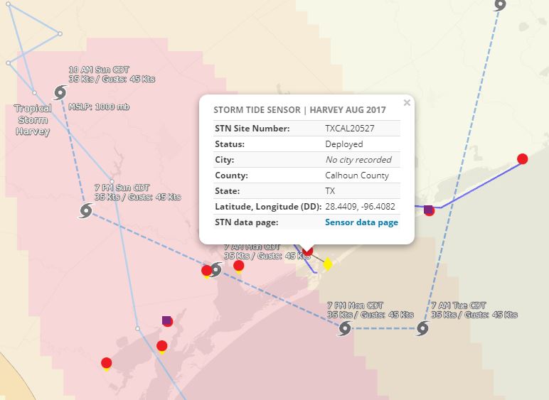
See http://stn.wim.usgs.gov/fev/#HarveyAug2017

See more on the USGS Harvey PageĀ  https://www.usgs.gov/harvey

Filed Under: Emergency Response, Environment, Top Text Lead Story Tagged With: harvey, hurricane, USGS

Editor’s Picks

OpenAerialMap – The open collection of aerial imagery

Google Announces that Google Earth Pro is now free

Event Review, Commercial Drone Expo

DigitalGlobe Top Images from 2014 – The fourth annual Top Image contest

See More Editor's Picks...

Recent Industry News

How Enterprises Are Using AI to Automate 80% of Customer Interactions With Voice Agents

June 16, 2026 By GISuser

Why On Cloud Shoes Are Worth the Price in Mexico

June 16, 2026 By GISuser

Jinghong vs XAG Agricultural Drones: A Comprehensive Comparison Guide

June 16, 2026 By GISuser

Why Adults Are Trimming Their Routines for Travel and Busy Weeks

June 10, 2026 By GISuser

Hot News

State of Data Science Report – AI and Open Source at Work

HERE and AWS Collaborate on New HERE AI Mapping Solutions

Virtual Surveyor Adds Productivity Tools to Mid-Level Smart Drone Surveying Software Plan

Categories

Copyright gletham Communications 2015 - 2026

Go to mobile version