GIS user technology news

News, Business, AI, Technology, IOS, Android, Google, Mobile, GIS, Crypto Currency, Economics

  • Advertising & Sponsored Posts
    • Advertising & Sponsored Posts
    • Submit Press
  • PRESS
    • Submit PR
    • Top Press
    • Business
    • Software
    • Hardware
    • UAV News
    • Mobile Technology
  • FEATURES
    • Around the Web
    • Social Media Features
    • EXPERTS & Guests
    • Tips
    • Infographics
  • Blog
  • Events
  • Shop
  • Tradepubs
  • CAREERS
You are here: Home / Archives for harvey

High-Resolution Flood Imagery on Website, App Today to Assist Houston Relief Efforts

September 3, 2017 By GISuser

High-Resolution Flood Imagery on Website, App Today to Assist Houston Relief Efforts

The before-and-after imagery slider on Woolpert’s website allows local, state and federal officials and the public to navigate and enhance sites in Houston in the wake of Hurricane Harvey.

Filed Under: Earth Imaging - Remote Sensing, Emergency Response, Environment, Top Press Tagged With: flood, harvey, Houston, Imagery, Woolpert

Rains to From Tropical Storm Harvey Continue over Texas, Louisiana

August 28, 2017 By GISuser

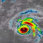
This infrared imagery from GOES-16 shows Tropical Storm Harvey earlier this morning, Monday, August 28, 2017.

Filed Under: Environment Tagged With: harvey, hurricane, NOAA, Texas

NOAA Satellite Imagery of Hurricane Harvey

August 28, 2017 By GISuser

hurricane harvey

Watch Harvey’s Movements from the Evening of August 24 to Noon on August 28

Filed Under: Environment, Top Press Tagged With: harvey, hurricane, Texas

Flood Resource – USGS Flood Event Viewer (FEV) #Hurricane #Harvey

August 27, 2017 By GISuser

FEV (an interactive map) provides viewable and downloadable flood event data

Filed Under: Emergency Response, Environment, Top Text Lead Story Tagged With: harvey, hurricane, USGS

USGS – Many Texas Beaches Likely to Erode, Be Overwashed, or Inundated by Hurricane Harvey

August 27, 2017 By GISuser

To learn more about USGS’ role providing science to decision makers before, during and after Hurricane Harvey, visit the USGS Hurricane Harvey page. UPDATE: This story has been revised to reflect new NOAA-National Hurricane Center storm surge projections which were released August 25 at 7 a.m.

Filed Under: Emergency Response Tagged With: harvey, hurricane, USGS

Federal Family and Partners Continue to Support State Response to Tropical Storm Harvey: Residents Urged to Heed Warnings from State, Local, and Tribal Officials

August 27, 2017 By GISuser

WASHINGTON – The federal government is actively providing support to states, local communities, and tribes as Hurricane Harvey, now downgraded to a Tropical Storm, continues to impact the coastline and inland areas of Texas. FEMA’s National Response Coordination Center (NRCC) in Washington, D.C., and Regional Response Coordination Center (RRCC) in Denton, Texas, continue 24-hour coordination of […]

Filed Under: Emergency Response Tagged With: FEMA, harvey, hurricane

Recent Industry News

Best Equipment Labels for Industrial Use: Ranked Systems That Survive Real-World Conditions

April 17, 2026 By GISuser

Building a Global Natural Brand: The Digital Journey of VedaOils

April 15, 2026 By GISuser

DeltaQuad partners with Meridein Group OÜ to strengthen UAS capability in the Baltics

April 15, 2026 By GISuser

The Complete Guide to Improving Home Safety and Efficiency with Dryer Vent Cleaning

April 12, 2026 By GISuser

Hot News

State of Data Science Report – AI and Open Source at Work

HERE and AWS Collaborate on New HERE AI Mapping Solutions

Virtual Surveyor Adds Productivity Tools to Mid-Level Smart Drone Surveying Software Plan

Categories

Copyright gletham Communications 2015 - 2026

Go to mobile version