GIS user technology news

News, Business, AI, Technology, IOS, Android, Google, Mobile, GIS, Crypto Currency, Economics

  • Advertising & Sponsored Posts
    • Advertising & Sponsored Posts
    • Submit Press
  • PRESS
    • Submit PR
    • Top Press
    • Business
    • Software
    • Hardware
    • UAV News
    • Mobile Technology
  • FEATURES
    • Around the Web
    • Social Media Features
    • EXPERTS & Guests
    • Tips
    • Infographics
  • Blog
  • Events
  • Shop
  • Tradepubs
  • CAREERS
You are here: Home / Archives for **Front Page / HUGE NEWS

Golden Software Expands 3D Drillhole Visualization and Overall Usability in Surfer Mapping Package

September 10, 2025 By GISuser

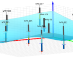
GOLDEN, Colorado, 10 September 2025 – Golden Software has continued to enhance the 3D drillhole viewing functionality in the latest release of its Surfer mapping and 3D visualization software package. Overall, the new version of Surfer provides users with several upgrades to save time and streamline creation of subsurface maps.

Filed Under: Around the Web, Business, HUGE NEWS, Software

State of Data Science Report – AI and Open Source at Work

September 10, 2025 By GISuser

State of Data Science Report

AI and Open Source at Work

Filed Under: Around the Web, Business, Featured TOP PR, HUGE NEWS, Top Press

The Mesa® 4 Rugged Tablet by Juniper® Systems is now available and shipping worldwide.

January 22, 2024 By GISuser

Experience rugged computing in any environment.

Experience rugged computing in any environment.

Filed Under: Business, GPS, Hardware, HUGE NEWS, Top Press Tagged With: AND, Available, Business, GPS, hardware, huge, juniper, mesa, News, now, press, rugged, shipping, systems, tablet, the, top, worldwide.

Webinar Topic: Cameras on Drones and Aircraft: Is Bigger Always Better?

August 8, 2023 By GISuser

Webinar Announcement Hosted by Eric Andelin CP, Senior Workflow Specialist at SimActive and guest speaker, Kevin Graville, System Sales Manager at Phase One. Date: Thursday, August 17th 2023 Register here: https://hubs.ly/Q01ZS6Wz0 Aerial photography continues to thrive as a tool for mapping in spite of alternatives such as Lidar. Pictures can be collected using relatively low-cost cameras and converted to […]

Filed Under: Business, Events, HUGE NEWS Tagged With: SimActive, Webinar

Recent Industry News

Best Equipment Labels for Industrial Use: Ranked Systems That Survive Real-World Conditions

April 17, 2026 By GISuser

Building a Global Natural Brand: The Digital Journey of VedaOils

April 15, 2026 By GISuser

DeltaQuad partners with Meridein Group OÜ to strengthen UAS capability in the Baltics

April 15, 2026 By GISuser

The Complete Guide to Improving Home Safety and Efficiency with Dryer Vent Cleaning

April 12, 2026 By GISuser

Hot News

State of Data Science Report – AI and Open Source at Work

HERE and AWS Collaborate on New HERE AI Mapping Solutions

Virtual Surveyor Adds Productivity Tools to Mid-Level Smart Drone Surveying Software Plan

Categories

Copyright gletham Communications 2015 - 2026

Go to mobile version