AQUAOSO launches groundbreaking data acclimation tool – A powerful suite of analytics and data management tools, GIS Connect is an opportunity for the agricultural finance sector to create long-term resilience for water and climate risk
Prioritizing the Planet: Effective Steps to Make Your Business More Eco-Friendly

If you’re the owner of a small business, you might think that its environmental impact is minor. But people who buy your products don’t see it this way. We face an environmental crisis, and customers are starting to vote for “go green” more and more. All businesses, regardless of their shapes, must analyze consumer’s behavior […]
Bay Park Data Solutions is First Esri Partner Network Organization to Receive the Nonprofit Specialty Designation From Esri

San Diego, CA, September 13, 2021 – Bay Park Data Solutions (Bay Park) is proud to be recognized as the FIRST to receive the new Nonprofit Specialty designation from Esri.
Planet Collaborates with Google Earth to Offer NICFI Tropical Forest Basemaps in Google Earth Engine
SAN FRANCISCO–(BUSINESS WIRE)–Planet, a leading provider of daily data and insights about Earth, today announced a new collaboration with Google Earth to make high-resolution data from Norway’s International Climate and Forests Initiative (NICFI) Satellite Data program available on the Google Earth Engine (GEE) platform. Insights from Planet’s analysis-ready data combined with the power of Google’s […]
OceanWise awarded the UK National Tide Gauge Contract

The prestigious ‘National Tide Gauge Network’ (NTGN) contract from the Environment Agency (EA), who own and operate 42 ‘Class A’ tide gauges on behalf of the UK Coastal Flood Forecasting (UKCFF), has been awarded to OceanWise Ltd who alongside RS Divers, will deliver this multi-year contract.
Maxar Satellite Imagery: Flooding in New Jersey
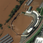
Maxar collected new high resolution satellite imagery yesterday (September 2nd at 11:52 AM, Eastern) that shows historic flooding along the Raritan River in New Jersey. As the remnants of Hurricane Ida moved through the northeast of the United States, the storm dropped record-breaking rainfall causing floods and damage in multiple towns and communities including Somerville, Manville, […]
Global geospatial leaders unite at Cambridge Conference to discuss climate change action

Ordnance Survey is hosting the Cambridge Conference, a prestige event held every four-years since 1928, bringing together leaders from national mapping and geospatial agencies from across the globe to connect and discuss how they are supporting their national governments in the response to one of the biggest global challenges of our time.
Intermap Supports Conservation of the Snow Leopard in Mongolia
High-resolution, 3D data is essential in guiding conservation research
Can we finally predict earthquakes? AETA may have figured it out
It has been a question asked among many people, especially those living in and around earthquake-affected regions, can we predict the occurrence of an earthquake? Seismic experts have proclaimed that earthquakes cannot be predicted, as numerous variables must be taken into consideration that have made people believe it is impossible.
Esri and National Geographic Society Launch Global Storytelling Challenge
Challenge Encourages Use of Geospatial Software to Inspire Ocean Conservation