GIS user technology news

News, Business, Technology, Mobile, GIS, Crypto Currency, AI, Economics

  • PRESS
    • Submit PR
    • Top Press
    • Business
    • Software
    • Hardware
    • UAV News
    • Mobile Technology
  • FEATURES
    • Around the Web
    • Social Media Features
    • EXPERTS & Guests
    • Tips
    • Infographics
  • Events
  • CAREERS
  • Advertising and Sponsored Posts
    • Advertising and Sponsored Posts
    • Submit Press
  • Shop
  • Tradepubs
  • Around the Web
  • Cool Links
You are here: Home / Archives for flood

Innovative Solutions for Flood Prevention in Residential Areas

July 3, 2024 By GISuser

Flooding poses a significant risk to residential areas, causing extensive damage to properties and posing threats to safety. With climate change increasing the frequency and intensity of storms, it is crucial to adopt effective flood prevention strategies. Homeowners and communities must implement innovative solutions to safeguard their homes. From landscaping techniques to technological advancements, there […]

Filed Under: Around the Web Tagged With: areas, around, flood, for, innovative, prevention, residential, solutions, the, web

Flood Engineers in Brisbane And Their Role in Safeguarding the City Against Natural Disasters

July 3, 2024 By GISuser

Brisbane, known for its vibrant culture and stunning landscapes, is also prone to natural disasters, particularly floods. The city’s subtropical climate and proximity to rivers make it vulnerable to heavy rains and rising water levels. To mitigate the risks and protect residents, flood engineers play a crucial role in safeguarding Brisbane against these natural disasters. […]

Filed Under: Around the Web Tagged With: against, AND, around, brisbane, city, disasters, Engineers, flood, natural,, role, safeguarding, the, their, web

Maxar Satellite Imagery: Flooding Along Fraser River, British Columbia

November 23, 2021 By GISuser

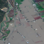
Maxar collected new satellite imagery on Friday (November 19th) of the ongoing flooding in Sumas Prairie to the east of Abbotsford, British Columbia, Canada. Highways, roads and many buildings and farms remain under water.

Filed Under: Earth Imaging - Remote Sensing, Emergency Response, Top Text Lead Story Tagged With: flood, Imagery, maxar

Maxar Satellite Imagery: Flooding in New Jersey

September 4, 2021 By GISuser

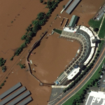
Maxar collected new high resolution satellite imagery yesterday (September 2nd at 11:52 AM, Eastern) that shows historic flooding along the Raritan River in New Jersey. As the remnants of Hurricane Ida moved through the northeast of the United States, the storm dropped record-breaking rainfall causing floods and damage in multiple towns and communities including Somerville, Manville, […]

Filed Under: Earth Imaging - Remote Sensing, Emergency Response, Environment, Top Press Tagged With: flood, hurricane, maxar, New Jersey

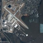
Maxar Technologies collected new satellite imagery of Davenport, Iowa flooding caused by the Mississippi River

May 6, 2019 By GISuser

Maxar Technologies collected new satellite imagery yesterday, May 4, 2019, of Davenport, Iowa and the downtown flooding caused by the Mississippi River

Filed Under: Business, Earth Imaging - Remote Sensing Tagged With: flood, Imagery

DigitalGlobe Satellite Imagery: Flooding in U.S. Midwest

March 19, 2019 By GISuser

DigitalGlobe’s WorldView-2 satellite collected new imagery March 18, 2019 of the historic flooding of the Missouri and Platte rivers south of Omaha, Nebraska.

Filed Under: Earth Imaging - Remote Sensing, Emergency Response Tagged With: DigitalGlobe, flood

Neptune Flood Expands Coverage to Six Additional States

March 13, 2019 By Editor

First Fully Online Flood Insurance with Up-To-The-Minute Mapping of Flood Risk Now Available in 27 States

Filed Under: Business Tagged With: flood

Panoramic Imagery for Canyon Gate Subdivision, Fort Bend County, Texas

September 6, 2017 By GISuser

Panoramic Imagery for Canyon Gate Subdivision, Fort Bend County, Texas

An update from Fort Bend County, Texas and their recent use of Esri Startup company, GroundVu, for obtaining 3D imagery of flood areas.

Filed Under: Earth Imaging - Remote Sensing Tagged With: flood, Panoramic Imagery, Texas

High-Resolution Flood Imagery on Website, App Today to Assist Houston Relief Efforts

September 3, 2017 By GISuser

High-Resolution Flood Imagery on Website, App Today to Assist Houston Relief Efforts

The before-and-after imagery slider on Woolpert’s website allows local, state and federal officials and the public to navigate and enhance sites in Houston in the wake of Hurricane Harvey.

Filed Under: Earth Imaging - Remote Sensing, Emergency Response, Environment, Top Press Tagged With: flood, harvey, Houston, Imagery, Woolpert

New Warning System Identifies Flash Drought Quickly

July 18, 2017 By GISuser

New Warning System Identifies Flash Drought Quickly

Agricultural crops can wither in a flash when the days turn hot, the air dries, the rain stops and moisture evaporates quickly from the soil. A new early warning system can help alert managers and others as drought begins to happen.

Filed Under: Emergency Response, Top Press Tagged With: flood, USGS

Next Page »


featured podcast

Recent Features

Space Flight Laboratory (SFL) Announces Successful Launch & Deployment of HawkEye 360’s Cluster 11

FOSS4G NA 2024: The Premier Open Source Geospatial Conference Returns to St. Louis, September 9-11

Photographer Touch Reveal the Top Cameras, Lenses, and Photo Editing Tools of 2022

Digitalization and Simulation at the North Pole

Natural Gas District & GIS-Centric Asset Management

More Posts from this Category

Categories

Recent Posts

  • What is the Accuracy of AI Image Detectors?
  • How To Create A Safe And Thriving Environment For Your Business And Family
  • WWDC 2025: Apple’s Vision for the Future
  • Hosting Corporate Events and Birthdays at a VR Club: Why It’s a Great Choice
  • Why Virtual Reality Franchises Are Shaping the Next Era of the Entertainment Industry

RSS Career Tips

  • Four Characteristics of the Best Virtual Employees
  • 28 Tools to Conquer the Social Media Recruiting World
  • 8 Questions Employers Should Ask About Coronavirus
  • Jobcase Launches Free Unemployment Resource Center for Workers Impacted by COVID-19
  • Must-Have Gadgets and Technology for the Remote Office Worker

RSS Tech pubs

  • Closing the Gaps: Achieving Fully Automated High-Throughput Bioprocessing
  • Integrated distribution management
  • Zero Trust: The Next Evolution of Security Architecture

RSS Computers

  • How the Cloud is Reshaping Virtual Desktops
  • Millennials as Brand Advocates - New Research Study Results
  • Vehicles Best Practices Installation Guide

RSS HR Tips

  • Future of Work: The APAC View
  • What Is an Agile Workspace?
  • Public Works & Utilities

RSS Gov Tech

  • Government Procurement: Technology: Solving Problems for Government
  • IWCE News Desk: Public Safety Communications
  • IWCE News Desk: Nemergent, Frequentis

RSS UAV news

  • DJI Matrice 4 Series Brings Intelligence to Aerial Operations
  • Virtual Surveyor Adds Productivity Tools to Mid-Level Smart Drone Surveying Software Plan
  • Nokia and Swisscom Broadcast to deploy largest Drones-as-a-Service network

RSS Geojobs

  • Senior Systems Administrator
Copyright gletham Communications 2011-2022

Go to mobile version