GISuser.com

Mobile, Technology, and Business news

  • PRESS
    • Submit PR
    • Top Press
    • Business
    • Software
    • Hardware
    • UAV News
    • Mobile Technology
  • FEATURES
    • Around the Web
    • Social Media Features
    • EXPERTS & Guests
    • Tips
    • Infographics
  • Events
  • CAREERS
  • Advertise
    • Advertise
  • Shop
  • Tradepubs
  • facebook
You are here: Home / Archives for earthquake

Can we finally predict earthquakes? AETA may have figured it out

August 18, 2021 By GISuser

It has been a question asked among many people, especially those living in and around earthquake-affected regions, can we predict the occurrence of an earthquake? Seismic experts have proclaimed that earthquakes cannot be predicted, as numerous variables must be taken into consideration that have made people believe it is impossible.

Filed Under: Environment Tagged With: earthquake

New Partnership to Build Public Awareness of Global Earthquake Risk

August 24, 2019 By GISuser

USGS and the Global Earthquake Model Foundation take steps to save lives worldwide

Filed Under: Environment Tagged With: earthquake

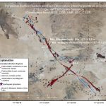
M6.2 Earthquake – 10km SE of Norcia, Italy – Interactive Impact Summary Map

August 24, 2016 By GISuser

M6.2 Earthquake – 10km SE of Norcia, Italy Impact Summary Map via Esri

Filed Under: Maps and Cartography Tagged With: earthquake, Italy, Norcia

OSM Mapathon for Ecuador Earthquake at Heidelberg University on Thursday April 21st

April 20, 2016 By GISuser

An update via the GIS Science news blog

Filed Under: Emergency Response, Environment Tagged With: earthquake, Ecuador Earthquake, OSM

New Book ‘Earthquake Time Bombs’ Sounds the Alarm to Protect Vulnerable Earthquake-prone Cities Around the World

February 3, 2016 By GISuser

Earthquake Time Bombs

Raises the Question: Where Will the Next Great Urban Earthquake Strike? In his new book, Earthquake Time Bombs, Yeats discusses the importance of convincing the public to take action before an earthquake strikes their city and that the next damaging earthquake will help drive change

Filed Under: Environment, Top Press Tagged With: book, earthquake

New Book ‘Earthquake Time Bombs’ Serves As Wake-up Call for Earthquake-prone Cities Around the World

January 13, 2016 By GISuser

Scientist Says Implication of Earthquake Time Bombs are Worldwide

Filed Under: Environment Tagged With: book, earthquake

Caltech-Led Team Looks In Detail at the April 2015 Earthquake in Nepal

August 6, 2015 By GISuser

For more than 20 years, Caltech geologist Jean-Philippe Avouac has collaborated with the Department of Mines and Geology of Nepal to study the Himalayas—the most active, above-water mountain range on Earth—to learn more about the processes that build mountains and trigger earthquakes.

Filed Under: Emergency Response, Environment Tagged With: caltech.edu, earthquake, nepal

HOT requesting help with Nepal emergency mapping response

May 12, 2015 By GISuser

A message on behalf of the HOTOSM humanitarian mapper team in response to the crisis in Nepal – This message comes via way of the OSM-Colorado Group

Filed Under: Around the Web, Emergency Response, Environment Tagged With: earthquake, HOTOS, l emergency mapping response, Nepa, OSM

Nepal earthquake smart maps released

April 29, 2015 By GISuser

Two interactive smart maps that provide unique insights into Nepal’s earthquake tragedy have been released by global mapping giant Esri.

Filed Under: Environment Tagged With: earthquake, nepal, Nepal earthquake

Kathmandu, viewed by Pléiades satellites, before and after the earthquake. 28.04.2015

April 28, 2015 By GISuser

Kathmandu, viewed by Pléiades satellites, before and after the earthquake. 28.04.2015

Following Nepal’s devastating magnitude-7.8 earthquake on Saturday, Airbus Defence and Space has acquired Pléiades satellites imagery to support the International Charter and Copernicus Emergency Management Service. The data acquired will assist in assessing the damage and help rescue organisations in the delivery of humanitarian aid

Filed Under: Earth Imaging - Remote Sensing, Environment Tagged With: earthquake, Kathmandu, nepal, Pléiades satellites

Next Page »

Feed

  • RSS


GIS jobs


Recent Features

Digitalization and Simulation at the North Pole

Natural Gas District & GIS-Centric Asset Management

5 Ways Technology Is Affecting The Sharing Economy

Spotlight – Township Canada: Explore Canadian Legal Land Descriptions on a Map

GeoGeeksinCars – The one in “Tippy” the right-hand drive Mitsubishi, at DevSummit

More Posts from this Category

Categories

Recent Posts

  • Filing a Chapter 7 Bankruptcy Before 8 Years: What You Need to Know
  • How to Grab knowledge about Profitable BTC Trading in Bhutan?
  • Authentic and useful details about bitcoin trading in Belarus
  • Top 8 Reasons to Create a Business Plan
  • Compatibility of Personality Types and Zodiac Signs

RSS Career Tips

  • Four Characteristics of the Best Virtual Employees
  • 28 Tools to Conquer the Social Media Recruiting World
  • 8 Questions Employers Should Ask About Coronavirus
  • Jobcase Launches Free Unemployment Resource Center for Workers Impacted by COVID-19
  • Must-Have Gadgets and Technology for the Remote Office Worker


shop for geogeek swag

RSS Tech pubs

  • The Latest Trends in Cybersecurity
  • Addressing Personalized Medicine's Complexity Problem: Examples from Parkinson's Disease
  • Your 7-Step Roadmap To Peak Season Success

RSS Computers

  • HackerProof: Your Guide to PC Security
  • Windows... On Speed
  • The Idiot's Ultimate Guide to Build Your Own PC

RSS HR Tips

  • Sell Smart: The Benefits of Specialty Web Stores for Sale Events
  • Geospatial mapping performance: Get your questions personally answered by utility experts
  • Diversity Intelligence: How to Create a Culture of Inclusion for your Business ($15.00 Value) FREE for a Limited Time

RSS Gov Tech

  • 7 Steps to Achieving Security with Zero Trust
  • City of Los Angeles Stays One Step Ahead with Intelligence from Recorded Future
  • Zero Trust Architecture Starts With Modern ICAM

RSS UAV news

  • Dedrone Launches DedronePortable for Military and Commercial Entities Around the World
  • Preliminary Agenda Announced for 2022 UAS Summit & Expo
  • Draganfly Deploys Versatile Situational Assessment Drones to Ukraine

RSS Geojobs

  • IT Endpoint Technician
  • Help Desk Technician
Copyright Spatial Media LLC 2003 - 2015