
The prestigious ‘National Tide Gauge Network’ (NTGN) contract from the Environment Agency (EA), who own and operate 42 ‘Class A’ tide gauges on behalf of the UK Coastal Flood Forecasting (UKCFF), has been awarded to OceanWise Ltd who alongside RS Divers, will deliver this multi-year contract.
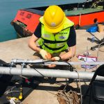
Tidal Monitoring at the Port of Waterford
OceanWise are proud to announce a recent contract win with the Port of Waterford to help with their aim to consolidate, manage and better share environmental data collected by a diverse range of environmental sensors across their port jurisdiction.
OceanWise – Delivering site surveys and installations remotely

In early 2020 the OceanWise team was putting the final touches to an environmental monitoring system which was destined for Africa. Despite mounting restrictions imposed amid the global Covid-19 pandemic, the team innovated using remote working to ensure delivery and installation of the all-important system, whilst maintaining high standards throughout.
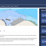
The European Marine Energy Centre (EMEC) improves Data Management and GIS Capability

As global energy consumption increases and climate change makes headlines across the world, developing new technologies to harness energy from our oceans to generate electricity is now more important than ever.
OceanWise wins more contracts to deliver robust solutions
OceanWise wins more contracts to deliver robust solutions to ports and harbours in the UK and overseas
Students and Researchers now benefit from access to OceanWise Marine Mapping via Digimap™
OceanWise’ intelligent marine mapping data is now accessible to students in Further and Higher Education across the British Isles via Digimap™ the online map and data delivery service provided by EDINA, based at the University of Edinburgh.
OceanWise provides mapping data and expertise to Blue Marine Foundation’s ‘Big Marine Data Project’

The Blue Marine Foundation, a charity dedicated to creating marine reserves and establishing sustainable models of fishing, has embarked on a “Big Data” project which seeks to investigate how data can be used to support safety in inshore waters.
OceanWise adds new software extension which drastically reduces segmentation time for marine images
OceanWise has added a dynamic software Extension to Maritime Toolbar for Esri ArcMap, which powerfully and easily helps the user to manipulate maritime data.
OceanWise’s Will Girard wins at the 2018 Apprentice of the Year Awards

OceanWise’s Will Girard, who started with the team in September 2016, has won an award in recognition of his high standards of achievement, outstanding commitment and excellent progression at the recent PETA Apprentice of the Year Awards 2018. Will is pictured below receiving his award from the Lord Mayor of Portsmouth.
OceanWise to host Marine Data Management and GIS Workshop in Scotland
OceanWise invites you to its free-to-attend Marine Data Management & GIS Workshop, on Tuesday 23rd May 2017 at the Royal Society of Edinburgh, 22-26 George St, Edinburgh EH2 2PQ.