
Yesterday (September 17), in between the clouds, Maxar Technologies’ WorldView-3 satellite collected new satellite imagery of the aftermath of Hurricane Sally that reveals damage to many homes, businesses and infrastructure along the Alabama Gulf coast.
Monitor the World’s Air Pollution – Real Time Air Quality Index Map

With wildfires raging in pretty in the Western regions of the USA, the topic of air quality is on the minds of many, and for very good reason! Air quality in many parts of the western USA and Canada are reporting pollution data readings that are the highest in the World!
Esri and UN Launch Global Storytelling Competition

Competition Encourages Use of Geospatial Software to Spread Awareness of Sustainable Development REDLANDS, Calif.—Esri, the global leader in location intelligence, and the United Nations (UN) Sustainable Development Solutions Network (SDSN) have launched the 2020 ArcGIS StoryMaps Competition for the Sustainable Development Goals. The SDSN is a leading nongovernmental organization (NGO) working to mobilize global scientific […]
Golden Software Improves Surfer® File Handling for Faster Mapping

GOLDEN, Colorado, 9 September 2020 – Golden Software, a developer of affordable 2D and 3D scientific modeling packages, has made it faster and easier than ever to create maps in the latest version of its Surfer® gridding, contouring, and 3D surface mapping product. Additionally, Surfer users will find it is simpler to present, share and […]
MCH Strategic Data Releases New Map to Provide School District Status Updates

MCH Releases New Resource for Fall School District Plans – Rapidly Changing School District Plans and Operations Updated Daily Through Fall Overland Park, KS, August 19, 2020—MCH Strategic Data has announced a new map resource to stay informed of the rapid changes to public school district plans and operations now and throughout the fall. To […]
Ease Up or Lock Down? New App Shows COVID-19 Spikes and Trends in Your Community

REDLANDS, Calif.—Esri, the global leader in location intelligence, announced today that it released a new app (https://livingatlas.arcgis.com/covidpulse) to help stakeholders and the public understand how COVID-19 is trending in every state and county in the US. The daily-updated app, which visualizes trend lines for new cases, deaths, as well as cumulative cases, tracks case data […]
Space Talent Launches New Career Platform for Commercial Space Industry

NEW YORK—Space Capital, an early-stage venture capital firm focused on the Space economy, today announced the official launch of Space Talent (www.spacetalent.org), the leading online portal for careers in the space industry and its broader ecosystem. “Space Talent addresses a critical need in the industry right now and is a top priority for our organization,” […]
Satellite Imagery: LNU Lightning Wildfire in California via Maxar

Maxar’s WorldView-3 satellite collected new imagery yesterday afternoon (August 20th) of the LNU Lightning Complex wildfire burning in Sonoma County near Healdsburg, California.
Commercial UAV Expo Americas Virtual Conference to Feature DRONERESPONDERS Public Safety UAS Content produced by AIRT

Digital environment will allow attendees from around the world to engage in targeted educational content to learn how first responders are using sUAS to save lives.
Valqari Introduces the Drone Delivery Station
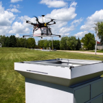
Six-storage delivery solution showcases the start-up’s continued leadership in last inch drone delivery logistics