GIS user technology news

News, Business, AI, Technology, IOS, Android, Google, Mobile, GIS, Crypto Currency, Economics

  • Advertising & Sponsored Posts
    • Advertising & Sponsored Posts
    • Submit Press
  • PRESS
    • Submit PR
    • Top Press
    • Business
    • Software
    • Hardware
    • UAV News
    • Mobile Technology
  • FEATURES
    • Around the Web
    • Social Media Features
    • EXPERTS & Guests
    • Tips
    • Infographics
  • Blog
  • Events
  • Shop
  • Tradepubs
  • CAREERS
You are here: Home / Archives for maxar

Maxar Technologies Announces its Intention to Acquire Vricon, Inc.

June 24, 2020 By GISuser

Maxar Technologies Announces its Intention to Acquire Vricon, Inc. to Accelerate Growth in Emerging Markets for 3D Technology and Extend its Lead in Earth Intelligence

Filed Under: acquisitions and funding, Business, Earth Imaging - Remote Sensing Tagged With: acquisition, maxar

Satellite Imagery: Galwan Valley and Disputed India-China Border

June 23, 2020 By GISuser

tank company and artillery_north of gogra_22may2020

Maxar Technologies collected new high-resolution satellite imagery yesterday (June 22nd) of the disputed Galwan Valley and the Line of Actual Control (LAC) between India and China.  In the recent imagery, personnel are actively working with earth moving equipment on the dirt road that approaches the forward position (known as Patrol Point 14) near the LAC […]

Filed Under: Earth Imaging - Remote Sensing Tagged With: maxar, Satellite Imagery

Satellite Imagery: Washington, DC and Black Lives Matter Street Mural

June 7, 2020 By GISuser

Satellite Imagery: Washington, DC and Black Lives Matter Street Mural

Maxar collected new satellite imagery this afternoon of Washington D.C. at 12:08 PM EDT that shows people gathered near the entrance to Lafayette Square and at the steps to the Lincoln Memorial.

Filed Under: Earth Imaging - Remote Sensing, Emergency Response, Top Press, Top Text Lead Story Tagged With: maxar, Satellite Imagery

Maxar Releases Satellite Imagery: Vanuatu Before / After Cyclone Harold

April 10, 2020 By GISuser

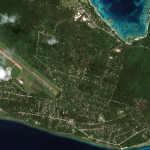
Maxar collected new imagery today (April 10th) of Vanuatu and the aftermath of the category 5 cyclone (Harold) that recently struck the island nation. Below are before/after images that primarily focus on the island of Espiritu Santo and the main city of Luganville. As you will see in the imagery comparisons, this once lush island […]

Filed Under: Earth Imaging - Remote Sensing, Emergency Response Tagged With: maxar

Satellite Imagery – Locations around the World Affected by #coronavirus COVID-19

March 6, 2020 By GISuser

great mosque and kaaba_mecca_before coronavirus_14feb2020

Maxar Technologies collected new satellite imagery from multiple locations around the world as the novel coronavirus, COVID-19, continues to spread.

Filed Under: Earth Imaging - Remote Sensing, Emergency Response Tagged With: coronavirus, Imagery, maxar

Satellite Imagery: Wildfires in New South Wales, Australia

January 5, 2020 By GISuser

Maxar collected new satellite imagery, January 4, 2020, of the wildfires in Victoria and New South Wales, Australia

Filed Under: Earth Imaging - Remote Sensing, Emergency Response, Environment, Top Press Tagged With: maxar, wildfire

Satellite Imagery: Flooding In Venice, Italy

November 15, 2019 By GISuser

overview of venice_14nov2019

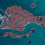
On November 14, Maxar’s GeoEye-1 satellite collected new imagery of Venice, Italy. Floodwaters can be seen across sections of the city, including most notably at St. Mark’s Square (Piazza San Marco) and around the Basilica (Basilica di San Marco).

Filed Under: Earth Imaging - Remote Sensing Tagged With: maxar

Maxar Collects satellite imagery of the Kincade fire #California #Wildfire

October 31, 2019 By GISuser

Satellite Imagery: New Kincade Fire Images

From Maxar: The Maxar News Bureau has gathered a new set of satellite imagery of the Kincade fire, which continues to burn in northern California near Santa Rosa. The images include sets from October 27th as well as October 30th. As you will see via the imagery, the fire burned very close to the city of […]

Filed Under: Earth Imaging - Remote Sensing, Emergency Response, Environment, Top Press Tagged With: California, maxar, wildfire

Maxar Shares Satellite Imagery of California Wildfires

October 25, 2019 By GISuser

geyserville california and fire_24october2019_swir satellite image

An update via Mxar: Maxar’s WorldView-3 satellite collected a set of new images yesterday, October 24th of the Kincade wildfire near Sonoma, California.

Filed Under: Earth Imaging - Remote Sensing, Top Press Tagged With: California, Imagery, maxar, wildfire

Maxar Satellite Imagery shows Golden Ray Carrier Ship Capsizing

September 11, 2019 By GISuser

Satellite Imagery: Golden Ray Capsizing

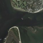
Maxar’s WorldView-2 satellite collected a new image  (September 10th) of the Golden Ray—the car carrier ship that capsized on Sunday in the middle of Saint Simons Sound, near Brunswick, Georgia. The ship was reportedly carrying thousands of vehicles and overturned early on Sunday morning after departing from the nearby port of Brunswick.

Filed Under: Earth Imaging - Remote Sensing Tagged With: maxar

« Previous Page
Next Page »

Recent Industry News

The Future of Competitive Gaming: Why DMA Technology is the Ultimate Performance Edge

June 24, 2026 By GISuser

Milwaukee M18FHZ-0 Hackzall Reciprocating Saw – For hardcore cutting in a compact size

June 19, 2026 By GISuser

How Enterprises Are Using AI to Automate 80% of Customer Interactions With Voice Agents

June 16, 2026 By GISuser

Why On Cloud Shoes Are Worth the Price in Mexico

June 16, 2026 By GISuser

Hot News

State of Data Science Report – AI and Open Source at Work

HERE and AWS Collaborate on New HERE AI Mapping Solutions

Virtual Surveyor Adds Productivity Tools to Mid-Level Smart Drone Surveying Software Plan

Categories

Copyright gletham Communications 2015 - 2026

Go to mobile version