
Maxar Technologies collected new satellite imagery yesterday (October 28th) of the Blue Ridge and Silverado Wildfires that rapidly spread over the past couple of days in southern California, threatening multiple cities including Yorba Linda, Chino Hills and Irvine, California.
Satellite Imagery: East Troublesome Wildfire Near Rocky Mountain National Park, Colorado

Maxar Technologies collected new satellite imagery (October 22nd) of the East Troublesome Wildfire burning out of control near Rocky Mountain National Park (RMNP) in northern Colorado.
Maxar Satellite Imagery: Bobcat Wildfire, Northeast of Los Angeles

Maxar Technologies’ WorldView-3 satellite collected new images September 21 of the large Bobcat Fire burning northeast of Los Angeles, California.
Satellite Imagery: August Complex Fires, California

Maxar Technologies captured today (September 14) collected a set of satellite images of the August Complex wildfire, burning to the west of Chico, California and near the northern California coast.
Maxar Satellite Imagery: Phoenix and Talent Oregon Wildfires

Maxar Technologies collected new satellite imagery over the last two days of the intense wildfires burning across Oregon, focusing in on the aftermath of the Alameda Wildfire (also known as the Glendower Wildfire). On Tuesday morning (September 8, 2020), wildfires tore through the southern Oregon towns of Phoenix and Talent that destroyed hundreds of homes […]
Satellite Imagery via Maxar : Cameron Peak Wildfire, Colorado

Maxar Technologies collected new satellite imagery September 6th, of Colorado’s Cameron Peak wildfire that grew in size and intensity over the weekend and spread significant smoke across the Front Range cities of Colorado, including Fort Collins. Below is a gallery of satellite images from that include both Maxar’s high-resolution images from early Sunday afternoon, as […]
Satellite Imagery: Before/After Imagery of Hurricane Laura Landfall in Louisiana
Maxar collected a set of new imagery today (August 27th) of the aftermath of Hurricane Laura as it rapidly moved through Cameron and Lake Charles, Louisiana. Significant damage to homes, buildings and infrastructure can be seen across the region. Satellite image ©2020 Maxar Technologies.
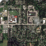
Satellite Imagery: LNU Lightning Wildfire in California via Maxar

Maxar’s WorldView-3 satellite collected new imagery yesterday afternoon (August 20th) of the LNU Lightning Complex wildfire burning in Sonoma County near Healdsburg, California.
Satellite Imagery: Pine Gulch Wildfire, Colorado (images via @Maxar)

Maxar collected new satellite August 8th & 9th of the Pine Gulch wildfire burning north of Grand Junction, Colorado. The fire, which has burned nearly 24,000 acres as of mid-day Sunday, is burning in a remote area approximately 18 miles north of Grand Junction in Mesa and Garfield counties.
Beirut Explosion: Maxar Technologies, Before-and-After Satellite Imagery
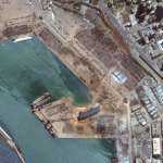
Several of Maxar’s satellites collected new imagery Aug 5, 2020 over Beirut that reveals the aftermath of the massive explosion in the port section of the city.