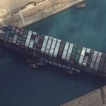
Maxar’s WorldView-2 collected new high-resolution satellite imagery this morning (March 26th) of the Suez canal and the container ship (EVER GIVEN)–a 1,300-foot ship operated by the Taiwan-based Evergreen Group–that remains stuck in the canal north of the city of Suez, Egypt. In today’s satellite imagery, multiple tug boats are positioned alongside the ship and dredging operations […]
Satellite Imagery @Maxar : SpaceX Starship SN10 Hours Before Launch

Maxar’s WorldView-3 satellite collected new high-resolution imagery today (March 3rd) of the SpaceX Starship SN10 launch activity at Boca Chica, Texas. Today’s imagery was collected at 11:05 AM Central Time, approximately 7 hours before the Starship successfully launched, returned to the launch site and subsequently exploded shortly after landing. The satellite imagery provides an excellent […]
Satellite Imagery: Protests In Yangon, Myanmar – @MaxarTechnologies

Maxar Technologies collected new satellite imagery this morning (at 10:52 AM local time, February 22nd) of the widespread protests that formed today across Yangon, Myanmar.
Satellite Imagery: Myanmar Protests and “We Want Democracy” mural
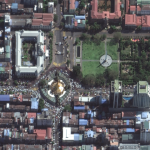
Maxar Technologies recently collected new satellite images of four cities in Myanmar where protests have been seen (and continue) including: Yangon, Mandalay, Myitkyina and Naypyitaw
Satellite Imagery of SuperBowl LV at Raymond James Stadium, Tampa Bay

Maxar Technologies’ GeoEye-1 satellite collected new imagery yesterday (February 7, 2021) at 11:39 AM EST of the Raymond James stadium in Tampa Bay, Florida—site of last night’s SuperBowl LV football game between the Kansas City Chiefs and the Tampa Bay Buccaneers.
Nighttime Satellite Imagery from @Maxar: Inauguration Celebrations in Washington, DC

While cloudy skies mostly obstructed Maxar’s overhead view of the U.S. presidential inauguration during the day yesterday (January 20, 2021), the company’s WorldView-3 satellite collected dramatic nighttime imagery (collected January 20th at 9:55 PM EST) that revealed the fireworks display that capped the celebration.
Satellite Imagery: US Capitol, January 7th via @Maxar
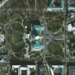
Yesterday (January 7th at 10:59 a.m. and 11:02 a.m. EST), two of Maxar Technologies’ high-resolution satellites collected new imagery of Washington D.C., including the U.S. Capitol and surrounding area. The imagery provides an excellent view of the inauguration stands/seats along the west side of the Capitol as well as an overview of the Capitol grounds.
Maxar Satellite Imagery: SpaceX Starship Facilities, Boca Chica, Texas

Maxar Technologies’ WorldView-3 satellite collected new imagery on December 10th of the SpaceX production and launch facilities in Boca Chica, Texas.
Satellite Imagery: Aftermath of Hurricane Iota in Providencia Island, Colombia @Maxar

Maxar Technologies collected new satellite imagery yesterday (November 21st) of the small Colombian island of Providencia, which suffered extreme damage from Hurricane Iota. Nearly all of the island’s infrastructure was destroyed from the powerful category 5 storm that struck the island on November 16th
Satellite Imagery: Earthquake Recovery Operations in Izmir, Turkey @Maxar
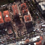
Maxar’s WorldView-3 satellite collected new high-resolution imagery today (3 November) of Izmir, Turkey that shows rescue and recovery operations continuing in the aftermath of last Friday’s magnitude 7.0 earthquake