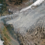
Maxar collected new satellite images on Sunday, August 8th of northern California and the Dixie wildfire that continues to burn and has become the state’s second largest wildfire in history.
Maxar Satellite Imagery: Miami Building Collapse, Before and After

Maxar collected new satellite imagery this morning (11:40 AM, Eastern; June 25th) of the collapsed Champlain Towers South condo complex in Surfside, Florida. Dozens of rescue vehicles can be seen around the collapsed building as search and recovery efforts continue throughout the day.
@Maxar Satellite Imagery: Falcon 9 Rocket with Cargo Dragon Capsule, Kennedy Space Center

Maxar collected new satellite images yesterday and today of the SpaceX Falcon 9 rocket with its Cargo Dragon capsule at SLC 39A in the Kennedy Space Center. Today’s WorldView-3 high resolution view shows the rocket at the launch pad approximately 70 minutes before its successful launch today (3 June).
Maxar Satellite Imagery: Train Derailment in Mexico City
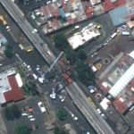
Maxar collected new satellite imagery (May 4, 2021) of the aftermath of the passenger train derailment that occurred on Monday night in southeastern Mexico City. According to media reports, a passenger train traveling along an elevated track derailed after a concrete overpass collapsed. At least 23 people were killed and 80 others were injured. In […]
Maxar Satellite Imagery of Crew Dragon 2 and Falcon 9 at Cape Canaveral

Maxar’s WorldView-3 satellite collected new imagery this morning (April 22nd at 11:13 AM, Eastern) of the Kennedy Space Center ahead of tomorrow morning’s SpaceX Falcon 9 launch with the Crew Dragon capsule that will carry four astronauts into orbit and a journey to the International Space Station (ISS).
Satellite Imagery @Maxar : Windsor Castle and St George Chapel, April 17th

Maxar collected new satellite imagery early this afternoon of Windsor Castle and St George Chapel, several hours before the funeral of Prince Philip, Duke of Edinburgh. The imagery was collected at 12:01 PM local time. A small crowd of people can be seen gathered along Thames Street near the grounds of the Castle.
Satellite Imagery via @Maxar : St. Vincent and Ongoing Volcanic Eruptions

Maxar collected new satellite imagery today of the Caribbean island of St. Vincent and the ongoing eruption of the La Soufriere volcano. In spite of heavy cloud cover (including ash clouds) in the area, today’s satellite view provides the first high-resolution look at the northwest coast of St Vincent and the large amount of ash […]
Satellite Imagery @Maxar : Piney Point Phosphate Wastewater Ponds, Florida

Maxar collected new satellite imagery today, April 5th, that reveals the leak in the retaining wall of a wastewater holding pond in Piney Point, Florida near Tampa Bay. The leak at the reservoir, first discovered last month, is situated next to an abandoned phosphate plant. Emergency crews are removing millions of gallons of water from […]
Satellite Imagery via @Maxar : Russian Nuclear Submarines Through Arctic Ice
Maxar collected new satellite imagery on March 27th that reveals the Russian naval exercise (known as Umka-2021) in progress in the Arctic.
March 28 Update – @Maxar WorldView-3 satellite shows close up of excavation around EVER GIVEN ship and dredging ops

March 28th Satellite Imagery Update on Suez Canal and EVER GIVEN Ship