Maxar Technologies collected new satellite imagery yesterday (November 21st) of the small Colombian island of Providencia, which suffered extreme damage from Hurricane Iota. Nearly all of the island’s infrastructure was destroyed from the powerful category 5 storm that struck the island on November 16th
-
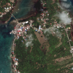
- Satellite Imagery: Aftermath of Hurricane Iota in Providencia Island, Colombia


Satellite image ©2020 Maxar Technologies