GISuser.com

GIS and Technology news for mapping professionals

  • PRESS
    • Submit PR
    • Top Press
    • Business
    • GIS, Geo Tech Software
    • Hardware
    • UAV News
    • Mobile Technology
    • Editor’s Top Picks
    • Get TOP Listing!
  • FEATURES
    • GeoGeeksinCars
    • 10 Question Q&A
    • FROM THE EDITOR
    • SPATIAL MEDIA AUTHORS
    • Social Media Features
    • EXPERTS & Guests
    • Listicles and Top 10 Lists
    • Infographics
    • VIDEOS
  • Events
    • Webinars
    • Submit event
    • Event Media Partner
  • CAREERS
    • Career Help Articles
    • People and Career News
    • Work from Home
    • About GeoJobs.BIZ
  • About
    • Advertise
      • Advertise wth GISuser
      • Media Kit Request Form
      • Directory
      • Submit Press
    • Contact GISuser
    • Meet the Editor
    • Social Media
      • AnyGeo Blog
      • GeoGeeks Podcast
      • Social Media Features
      • Like Us
    • SpatialMedia
      • LBSzone
      • LiDAR Magazine
      • Amerisurv
      • SymbianOne
    • RSS feed
  • Blog
  • Shop
  • Cloud Hosting
    • Amazon Cloud Hosting
    • WordPress cloud hosting
    • Dedicated servers USA
    • Linux Shared Hosting
    • Windows Shared Hosting
    • Web Development
    • SSL Certificate
  • Tradepubs
You are here: Home / * PRESS / Earth Imaging - Remote Sensing / Maxar Satellite Imagery: SpaceX Starship Facilities, Boca Chica, Texas

Maxar Satellite Imagery: SpaceX Starship Facilities, Boca Chica, Texas

December 12, 2020 By Editor

Maxar Technologies’ WorldView-3 satellite collected new imagery on December 10th of the SpaceX production and launch facilities in Boca Chica, Texas.

The imagery shows the aftermath of Tuesday’s Starship SN8 launch and subsequent dramatic landing. Additionally, the imagery provides a unique peek at one of the next Starship spacecraft standing upright inside the tall vertical assembly building.

Satellite Imagery: SpaceX Starship Facilities, Boca Chica, Texas

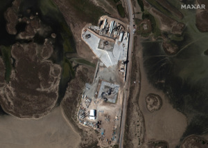
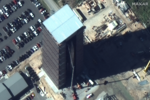
Satellite image ©2020 Maxar Technologies

Related Articles on GISuser:

  • Satellite Imagery of Suez Canal and Stuck Container Ship @MaxarSatellite Imagery of Suez Canal and Stuck Container Ship @Maxar
  • Satellite Imagery: Aftermath of Hurricane Iota in Providencia Island, Colombia @MaxarSatellite Imagery: Aftermath of Hurricane Iota in Providencia Island, Colombia @Maxar
  • Satellite Imagery @Maxar : Southern California’s Blue Ridge and Silverado WildfiresSatellite Imagery @Maxar : Southern California’s Blue Ridge and Silverado Wildfires
  • Satellite Imagery: East Troublesome Wildfire Near Rocky Mountain National Park, ColoradoSatellite Imagery: East Troublesome Wildfire Near Rocky Mountain National Park, Colorado
  • Satellite Imagery: August Complex Fires, CaliforniaSatellite Imagery: August Complex Fires, California
  • Maxar Satellite Imagery: Phoenix and Talent Oregon WildfiresMaxar Satellite Imagery: Phoenix and Talent Oregon Wildfires

Filed Under: Earth Imaging - Remote Sensing, Top Press Tagged With: Imagery, maxar, SpaceX


Editor’s Picks

Mayor Garcetti And Esri Launch Innovative Platform That Puts Open Data To Work

First Look – Los Angeles Opens the GeoHub – #OpenData for Citizens and Developers

10 Years of Images from ESRIUC and An All-Time Favorite Pic #esriuc

#DevSummit Video – A First Look at Drone2Map for ArcGIS

NOAA’s Lake Level Viewer of the Great Lakes

See More Editor's Picks...

About Editor

Glenn is a geographer and a GIS professional with over 20 years experience in the industry. He's the co-founder of GISuser and several other technology web publications.

Connect with GISuser

  • Facebook
  • Google+
  • LinkedIn
  • RSS
  • Twitter


GIS jobs

Recent Features

Digitalization and Simulation at the North Pole

Natural Gas District & GIS-Centric Asset Management

5 Ways Technology Is Affecting The Sharing Economy

Spotlight – Township Canada: Explore Canadian Legal Land Descriptions on a Map

GeoGeeksinCars – The one in “Tippy” the right-hand drive Mitsubishi, at DevSummit

More Posts from this Category

Categories


geoignite 2021

Recent Posts

  • The Top Jobs in 2021 Will all Be Related to Big Data
  • Why You Should Work with an Architect on Your Home
  • Event / Webinar Tip – The Avenza User Conference #AvenzaUC2021
  • Parrot and High Lander enhance drone fleet automation
  • USGIF Announces 2021 Lifetime Achievement Award Recipient

RSS Career Tips

  • Four Characteristics of the Best Virtual Employees
  • Jobcase Launches Free Unemployment Resource Center for Workers Impacted by COVID-19
  • 8 Questions Employers Should Ask About Coronavirus
  • Must-Have Gadgets and Technology for the Remote Office Worker
  • Must-Have Gadgets and Technology for the Remote Office Worker


shop for geogeek swag

RSS Tech pubs

  • Utilizing a Digital Platform to Drive Operational Improvements
  • Human Resources FrontRunners Report
  • Applicant Tracking FrontRunners Report

RSS Computers

  • The Essentials of Information Security Kit: Includes a Free PC Security Handbook - 2nd Edition eBook
  • iPad CTO Kit - including the iPad Tips and Tricks Guide for IT Executives and Managers
  • Windows... On Speed

RSS HR Tips

  • Applicant Tracking FrontRunners Report
  • Human Resources FrontRunners Report
  • How Diversity, Equity & Inclusion can Take Credit Unions into the Future

RSS Gov Tech

  • Am Law 100: Trends, Insights & How Firms Plan to Move Past the Pandemic
  • Hidden Risks to Patient Data Security
  • What Covid-19 Safety Expenses Can Public Entities Cover With Federal Funds?

RSS UAV news

  • Parrot and High Lander enhance drone fleet automation
  • NASA’s Mars Helicopter to Make First Flight Attempt Sunday
  • Rhode Island Signs Participating Addendum with DroneUp

RSS Geojobs

  • Help Desk Technician
Copyright Spatial Media LLC 2003 - 2015