More than 20 international organizations are involved in Arctic-focused communications exercises demonstrating the scope, quality and range of satellite capabilities supporting governments and NGOs in the polar regions
Satellite Imagery via @Maxar : Russian Nuclear Submarines Through Arctic Ice
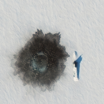
Maxar collected new satellite imagery on March 27th that reveals the Russian naval exercise (known as Umka-2021) in progress in the Arctic.
NGA Releases Biggest Collection of Arctic Elevation Data Yet at Esri FedGIS Conference
ArcticDEM Provides High Quality Elevation Data and Enables Communities to Take Action
Polar Knowledge Canada and NASA will Collaborate to Study Vulnerability of Arctic and Boreal Region
June 16, 2016 — Ottawa, Ontario — Polar Knowledge Canada – Polar Knowledge Canada (POLAR) and the National Aeronautics and Space Administration of the United States (NASA) have signed an agreement to coordinate environmental research and monitoring activities in the western Canadian Arctic.
OGC requests information to guide Arctic Spatial Data Pilot
24 February 2016 – The Open Geospatial Consortium (OGC®) requests information to help advance the “Arctic Spatial Data Pilot”.
Event – Arctic DEM Webinar
The Interagency Arctic Research Policy Committee(IARPC) is kicking off its 2016 public webinar series this month with the Arctic Digital Elevation Model (DEM) Project.
OGC announces new Arctic Spatial Data Infrastructure Project
4 January 2016 – The Open Geospatial Consortium (OGC®) announces a new OGC Interoperability Program project called the “Arctic Spatial Data Infrastructure Standards and Communication Pilot” (Arctic SDI Pilot).
Explore the Arctic with New Elevation data
This week from The Whitehouse blog, The Administration announces a collaboration to use high-resolution satellite imagery from DigitalGlobe to produce Digital Elevation Models of Alaska and the Arctic.
Tracking the Breakup of Arctic Summer Sea Ice
Newswise — As sea ice begins to melt back toward its late September minimum, it is being watched as never before. Scientists have put sensors on and under ice in the Beaufort Sea for an unprecedented campaign to monitor the summer melt.