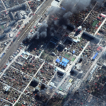
New Maxar satellite imagery (March 18-21, 2022) reveals continued Russian military activity in and around a number of key Ukrainian cities including Mariupol, Kyiv, and Chernihiv.
Maxar Reserves May 15 – June 13 Window for First WorldView Legion Launch

WESTMINSTER, Colo.–(BUSINESS WIRE)–Maxar Technologies (NYSE:MAXR) (TSX:MAXR), provider of comprehensive space solutions and secure, precise, geospatial intelligence, today announces it has reserved a window of May 15, 2022 – June 13, 2022 with SpaceX to launch the first two WorldView Legion satellites.
Maxar Satellite Imagery: Flooding Along Fraser River, British Columbia
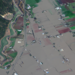
Maxar collected new satellite imagery on Friday (November 19th) of the ongoing flooding in Sumas Prairie to the east of Abbotsford, British Columbia, Canada. Highways, roads and many buildings and farms remain under water.
Maxar Satellite Imagery: Historic Images of 9/11 and the Upcoming 20th Anniversary

As we approach this Saturday’s 20th anniversary of the September 11, 2001 attacks, Maxar is providing a satellite imagery gallery of a number of the most significant sites that were collected shortly after the 2001 attacks, including: the American Airlines Flight 11 and United Airlines Flight 175 crash sites at the World Trade Center in New […]
Maxar Satellite Imagery: Flooding in New Jersey
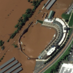
Maxar collected new high resolution satellite imagery yesterday (September 2nd at 11:52 AM, Eastern) that shows historic flooding along the Raritan River in New Jersey. As the remnants of Hurricane Ida moved through the northeast of the United States, the storm dropped record-breaking rainfall causing floods and damage in multiple towns and communities including Somerville, Manville, […]
Maxar Satellite Imagery: Hurricane Ida Damage, Louisiana

Maxar’s satellites collected an extensive amount of new imagery on August 31st over the Gulf Coast and southern Louisiana that help to convey some of the damage caused by Hurricane Ida.
Maxar Satellite Imagery: Caldor Fire Approaching Lake Tahoe

Maxar continues to monitor the Caldor wildfire as it approaches the southern edge of Lake Tahoe along the California-Nevada border. Maxar collected yesterday (August 31st) that shows closer views of South Lake Tahoe, the active fire lines and a large pyrocumulus cloud formed by the intense fire.
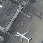
Maxar @MaxarTechnologies Satellite Imagery: Kabul, Hamid Karzai International Airport

Maxar collected new high-resolution satellite imagery yesterday (23 August) of Kabul that helps to convey visually the ongoing situation in and around Hamid Karzai International Airport. Large crowds of people can be seen at multiple checkpoints and security gates along the perimeter of the airport while several groups of people gather on the tarmac and […]
Maxar Awarded $26M Contract to Continue Development and Support for NGA’s Open Mapping Platform
WESTMINSTER, Colo.—Maxar Technologies (NYSE:MAXR) (TSX:MAXR), a trusted partner and innovator in Earth Intelligence and Space Infrastructure, today announced it has been awarded a five-year contract worth up to $26.4 million by the U.S. National Geospatial-Intelligence Agency (NGA) to sustain and enhance the National System for Geospatial Intelligence Open Mapping Enclave (NOME). Under the agreement, Maxar […]
Maxar Satellite Imagery: Kabul Airport, Afghanistan
Maxar collected new high-resolution satellite imagery this morning (10:36 AM local time, 16 August) of the chaotic scene underway at Kabul’s Hamid Karzai International Airport in Afghanistan as thousands of people converged on the tarmac and airport runways as countries attempt to evacuate personnel from the city.