GIS user technology news

News, Business, AI, Technology, IOS, Android, Google, Mobile, GIS, Crypto Currency, Economics

  • Advertising & Sponsored Posts
    • Advertising & Sponsored Posts
    • Submit Press
  • PRESS
    • Submit PR
    • Top Press
    • Business
    • Software
    • Hardware
    • UAV News
    • Mobile Technology
  • FEATURES
    • Around the Web
    • Social Media Features
    • EXPERTS & Guests
    • Tips
    • Infographics
  • Blog
  • Events
  • Shop
  • Tradepubs
  • CAREERS
You are here: Home / * PRESS / Emergency Response / Maxar Satellite Imagery: Kabul Airport, Afghanistan

Maxar Satellite Imagery: Kabul Airport, Afghanistan

August 16, 2021 By GISuser

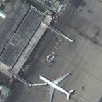
Maxar collected new high-resolution satellite imagery this morning (10:36 AM local time, 16 August) of the chaotic scene underway at Kabul’s Hamid Karzai International Airport in Afghanistan as thousands of people converged on the tarmac and airport runways as countries attempt to evacuate personnel from the city.

While one Turkish airliner prepares to takeoff from the airfield, security forces can be seen near one of the airport’s main runways attempting to prevent crowds of people from moving toward other aircraft and from blocking flight operations. Hundreds of people can also be seen at several of the airport perimeter gates and at intersections nearby.

Maxar Satellite Imagery: Kabul Airport, Afghanistan Inbox

Satellite image ©2021 Maxar Technologies

@MaxarTechnologies

Filed Under: Earth Imaging - Remote Sensing, Emergency Response, Top Text Lead Story Tagged With: Afghanistan, maxar

Editor’s Picks

Esri Story Map Reveals Where Your Thanksgiving Dinner Comes From

Maps attributed to the 13th-century traveler sketch what looks like the coast of Alaska

2014 Open Data for Development Research Grants – Call for Proposals

IN.gov Honored in 2014 Best of the Web Awards

See More Editor's Picks...

Recent Industry News

Eagleview White Paper Warns: Geospatial Intelligence Is About to Change Forever

March 4, 2026 By GISuser

Can You Use A Bong As A Dab Rig? What You Should Know

March 3, 2026 By GISuser

This advancement, which will save customers time and money, also  is a critical step towards Eagleview’s goal of building fully remote, scalable property intelligence and turning aerial data into actionable, interactive 3D models for planning, assessment, and decision-making.

February 26, 2026 By GISuser

Hot News

State of Data Science Report – AI and Open Source at Work

HERE and AWS Collaborate on New HERE AI Mapping Solutions

Categories

Copyright Spatial Media LLC 2003 - 2015

Go to mobile version