GIS user technology news

News, Business, AI, Technology, IOS, Android, Google, Mobile, GIS, Crypto Currency, Economics

  • Advertising & Sponsored Posts
    • Advertising & Sponsored Posts
    • Submit Press
  • PRESS
    • Submit PR
    • Top Press
    • Business
    • Software
    • Hardware
    • UAV News
    • Mobile Technology
  • FEATURES
    • Around the Web
    • Social Media Features
    • EXPERTS & Guests
    • Tips
    • Infographics
  • Blog
  • Events
  • Shop
  • Tradepubs
  • CAREERS
You are here: Home / Archives for Afghanistan

Maxar Satellite Imagery: Kabul Airport, Afghanistan

August 16, 2021 By GISuser

Maxar Satellite Imagery: Kabul Airport, Afghanistan Inbox

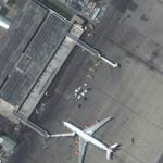
Maxar collected new high-resolution satellite imagery this morning (10:36 AM local time, 16 August) of the chaotic scene underway at Kabul’s Hamid Karzai International Airport in Afghanistan as thousands of people converged on the tarmac and airport runways as countries attempt to evacuate personnel from the city.

Filed Under: Earth Imaging - Remote Sensing, Emergency Response, Top Text Lead Story Tagged With: Afghanistan, maxar

Recent Industry News

Why Adults Are Trimming Their Routines for Travel and Busy Weeks

June 10, 2026 By GISuser

Top Benefits of AI Video Surveillance for Businesses and Public Spaces

June 5, 2026 By GISuser

How to Choose the Best Office Interior Designers in Delhi for End-to-End Projects

June 3, 2026 By GISuser

Why Bathroom Renovation Services Often Change More Than Just the Bathroom

May 20, 2026 By GISuser

Hot News

State of Data Science Report – AI and Open Source at Work

HERE and AWS Collaborate on New HERE AI Mapping Solutions

Virtual Surveyor Adds Productivity Tools to Mid-Level Smart Drone Surveying Software Plan

Categories

Copyright gletham Communications 2015 - 2026

Go to mobile version