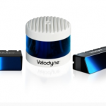
Using Velodyne Puck™ Sensors, Renu Robotics Revolutionizing Vegetation Management for Solar Energy Facilities
London Borough of Harrow creates digital twin with new street imagery and LiDAR data
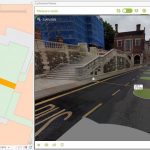
New approach will help improve Planning, Highways and Council Tax operations
Save the Date – Automotive LIDAR 2021, September 21-23, 2021

Automotive LIDAR 2021, coming up on September 21-23, 2021 (http://www.automotivelidar.com). The conference will be fully online again this year.
North Dakota Department of Transportation Selects GeoCue True View LIDAR/Imaging Technology for UAS Program
July 21, 2021 – HUNTSVILLE, AL – North Dakota Department of Transportation recently acquired a GeoCue True View 640 3D Imaging System (3DIS®) for their UAS program. GeoCue’s True View 3D Imaging Sensors allow for both drone LIDAR and imagery to be collected in a single flight on most UAS platforms.
North Dakota Department of Transportation Selects GeoCue True View LIDAR/Imaging Technology for UAS Program
July 21, 2021 – HUNTSVILLE, AL – North Dakota Department of Transportation recently acquired a GeoCue True View 640 3D Imaging System (3DIS®) for their UAS program. GeoCue’s True View 3D Imaging Sensors allow for both drone LIDAR and imagery to be collected in a single flight on most UAS platforms. The simultaneous data collection, […]
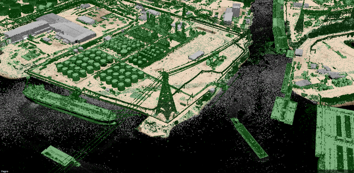
Teledyne Optech launches CZMIL SuperNova, a full geospatial bathymetric lidar solution with industry-leading depth penetration

The CZMIL SuperNova is powered by Teledyne CARIS processing software for creation of seamless topo/bathy data products
Seabed Selects Velodyne Lidar Sensors for Mobile Mapping System
Equipped with Velodyne Puck™ Sensors, Seabed Mobile Mapping Systems Support Marine Environment Protection and Sustainability
Velodyne Showcases Advanced Lidar Solutions at Auto Shanghai 2021
Velodyne’s Lidar Sensors Deliver Real-Time 3D Vision for Safer Mobility and Smarter Communities
Fugro wins repeat Geo-data solutions contract with State of Texas
Fugro has been awarded its second-consecutive Geo-data solutions contract by the Texas Department of Information Resources (DIR) to support the state’s Strategic Mapping Program (StratMap). The new contract will run up to 5 years, providing opportunities for the state and its local government, public utility and academia partners to contract with Fugro for comprehensive GIS, geospatial and geotechnical offerings. Projects completed under the StratMap contract will help DIR meet its goal of developing consistent digital Geo-data layers across the state […]
Virtual Surveyor Introduces Dropbox Integration for Easy Collaboration and File Access from Anywhere

AARSCHOT, Belgium, 6 April 2021 – Virtual Surveyor has introduced Dropbox integration in Version 8.0 of its popular drone surveying software. This means Virtual Surveyor users can now access their project files from anywhere while enjoying easy and affordable collaboration with team members and file sharing with external clients – even in low-bandwidth situations.