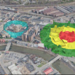
Fugro has partnered with RapidSOS in the US to deliver emergency dispatchers and first responders the dynamic, location-based information needed to speed incident response and improve situational awareness. The solution integrates a patent pending version of the company’s Fugro SIMmetryTM 3D mapping and visualisation technology within RapidSOS’s intelligent safety platform. The RapidSOS partnership enables Fugro […]
Fugro’s ground investigation links Dutch subsidence to former peat extraction
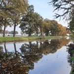
Fugro has completed important ground investigation research into the cause of subsidence and possible associated damage to rural homes located on a former peat extraction site between Nieuw-Amsterdam and Erica in the north-east of the Netherlands. Under a contract for the Municipality of Emmen, the Province of Drenthe, and the Vechtstromen Water Authority, Fugro delivered a multidisciplinary programme of geoconsulting, geotechnical investigation and foundation assessment, and analysed the results with DINO-loket data from the TNO Geological […]
Fugro awarded geotechnical contract for landmark La Gan offshore wind farm in Vietnam

Ho Chi Minh City, Vietnam, 20 July 2021 – La Gan Wind Power Development Corporation (La Gan Wind), owned by Copenhagen Infrastructure Partners (CIP), Asiapetro and Novasia, has awarded an offshore geotechnical contract to a consortium led by Vietsovpetro, PTSC G&S and Fugro. The award is part of CIP’s development plan for the La Gan offshore wind project in Vietnam which, with a potential capacity of 3.5 GW, will be one of the first […]
A first for Fugro as SpaceStar™ satellite positioning service heads into space
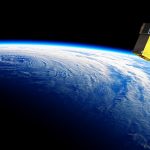
Fugro’s SpaceStar™ GNSS Precise Point Positioning (PPP) service is providing essential high-accuracy positioning in space for the first time. Loft Orbital, which flies and operates customer payloads on its YAM series of small satellites, launched their YAM-2 satellite, the first in space to be equipped with Fugro’s SpaceStar next-generation positioning technology, on 30 June into a 525 km sun-synchronous orbit from Cape Canaveral in Florida onboard a SpaceX Falcon 9 rocket.
Fugro wins repeat Geo-data solutions contract with State of Texas
Fugro has been awarded its second-consecutive Geo-data solutions contract by the Texas Department of Information Resources (DIR) to support the state’s Strategic Mapping Program (StratMap). The new contract will run up to 5 years, providing opportunities for the state and its local government, public utility and academia partners to contract with Fugro for comprehensive GIS, geospatial and geotechnical offerings. Projects completed under the StratMap contract will help DIR meet its goal of developing consistent digital Geo-data layers across the state […]
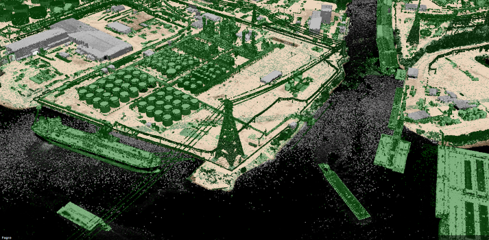
Fugro’s foundation testing supports major Canada-US infrastructure project

Fugro has completed foundation testing services for the Gordie Howe International Bridge project, a new border crossing between Windsor, Ontario, and Detroit, Michigan. The 2.5 km-long structure will improve travel and commerce across the Detroit River, which is responsible for 25 % of commercial traffic between Canada and the US. The project’s foundation contractors, GFL Environmental in Canada and Malcom Drilling in the US, engaged Fugro to confirm […]
Fugro’s virtual 3D network model helps keep powerlines safe in Tasmania
TasNetworks has awarded Fugro a new contract to deliver a 3D virtual network model and associated analytics for their power distribution network in Tasmania, Australia. Fugro started the project to acquire data in December 2020 and delivered the first datasets to TasNetworks last month.
Fugro wins multidisciplinary contract on Germany’s SuedLink renewables powerline

Vössing Engineers have awarded Fugro a geotechnical and water consulting contract to support the route planning, permitting and installation of 106 km of underground power cables on Section 2 of Germany’s new Suedlink powerline. Approximately 700 km long and due to be completed by 2028, the new Suedlink powerline is the country’s largest energy infrastructure project and will effectively transport electricity generated by offshore wind in the north of Germany to meet demand in the south.
Fugro partners on ‘4S’ global satellite observation seafloor mapping innovation

Fugro is participating in an EU co-funded research and innovation project to develop a remote solution for global satellite derived seafloor mapping. The 3-year project, named ‘4S’ (Satellite Seafloor Survey Suite), will develop an online cloud-based solution that will use highly automated earth observation algorithms and workflows to remotely map and monitor seafloor habitats, morphology and shallow water bathymetry. Fugro will lead the project’s business and integration actions, and their hydrographers and Geo-data specialists will evaluate the solution via several use cases around the globe.
Fugro to provide first topographic lidar base map for island nation of Palau

Fugro has been awarded a contract by the United Nations Development Programme (UNDP) to perform high-resolution topographic lidar base mapping for the Republic of Palau.