Vaughan, Ontario, CANADA – January 27, 2022 – Teledyne Geospatial will exhibit their latest lidar survey and mapping hardware and software solutions at Geo Week 2022, held at the Colorado Convention Center, in Denver, CO, USA, February 6-8.
Woolpert Earns U.S. Patent for High-Altitude, High-Resolution Topographic and Bathymetric Lidar Technologies
Woolpert collected high-altitude bathymetric lidar data from 3,048 meters, or 10,000 feet, over Fort Lauderdale, Fla., in 2021 via newly patented technology incorporated into the BULLDOG sensor. The data measured depths in excess of 55 meters. This image notes the range of depths in soundings and contours, courtesy of NOAA’s Electronic Navigational Charts map service. Image […]
Exelon Clearsight Acquires GeoCue’s True View 615 LIDAR/Imagery Mapping Sensor
Huntsville, AL – Exelon Clearsight, industry-leading robotics inspection company, recently acquired GeoCue Group Inc.’s True View 615 3D Imaging System, adding to their fleet of cutting-edge drone mapping technologies.
Virtual Surveyor Provides Comprehensive Insights into Drone Survey Data with Addition of Profile View
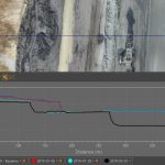
AARSCHOT, Belgium, 17 November 2021 – With the goal of giving surveyors a better understanding of the topographic data captured by drone mapping sensors, Virtual Surveyor has unveiled Profile View functionality in Version 8.4 of its popular surveying software. Profile View enables users to generate an elevation profile simply by drawing an onscreen traverse across any […]
GeoCue Expands True View 3DIS® Line with True View 435

Huntsville, AL – GeoCue is excited to announce that we are, once again, expanding our line of True View 3D imaging sensors (3DIS®). The True View 435 is our next-generation topography/wire grade LIDAR/Imaging sensor. Featuring a 16 beam Hesai PandarXT LIDAR unit, world class Trimble Applanix APX-15 Position/Orientation System (POS) and dual GeoCue mapping cameras, […]
GeoCue Releases True View EVO Embedded Metashape
Huntsville, AL – GeoCue Group Inc. is pleased to announce an embedded version of Agisoft’s Metashape photogrammetric processing software. We have built interfaces directly into our LIDAR/Photogrammetric processing software, True View EVO, for driving both an embedded version of Metashape (Metashape for EVO, MfE) as well as the full GUI version of Metashape Professional. This […]
2022 LIDAR LEADER AWARDS PROGRAM ANNOUNCED

Ceremony to be held at GeoWeek 2022 in Denver, Colorado
Virtual Surveyor Improves Point Cloud Workflow to Fully Leverage Drone LiDAR Payloads

AARSCHOT, Belgium, 7 September 2021 – Virtual Surveyor has developed an enhanced point cloud workflow for Version 8.3 of its drone surveying software that allows users to take full advantage of the new LiDAR payloads like the DJI Zenmuse L1. LiDAR drone sensor systems enable users to capture survey-grade elevation data even in vegetated terrain.
Using UAV LiDAR to obtain and analyse key metrics for operational forest management
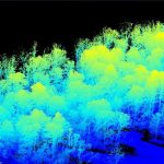
This new case study from Routescene demonstrates the value of UAV LiDAR point cloud data for operational forest management. Traditionally gathering metrics and information for forest management has been undertaken using airborne photogrammetry or by manually walking the site. More recently airborne LiDAR has been recognised as a useful tool and now drone derived LiDAR […]
SoCalGas to Use Gas Mapping LiDAR™ to Reduce Methane Emissions
Nation’s Largest Gas Distribution Utility Selects High-Tech Airborne Laser Solution from Bridger Photonics to Track Down Methane Emissions