GIS user technology news

News, Business, AI, Technology, IOS, Android, Google, Mobile, GIS, Crypto Currency, Economics

  • Advertising & Sponsored Posts
    • Advertising & Sponsored Posts
    • Submit Press
  • PRESS
    • Submit PR
    • Top Press
    • Business
    • Software
    • Hardware
    • UAV News
    • Mobile Technology
  • FEATURES
    • Around the Web
    • Social Media Features
    • EXPERTS & Guests
    • Tips
    • Infographics
  • Blog
  • Events
  • Shop
  • Tradepubs
  • CAREERS
You are here: Home / * PRESS / Business / Fugro wins repeat Geo-data solutions contract with State of Texas

Fugro wins repeat Geo-data solutions contract with State of Texas

April 9, 2021 By Editor

Fugro has been awarded its second-consecutive Geo-data solutions contract by the Texas Department of Information Resources (DIR) to support the state’s Strategic Mapping Program (StratMap). The new contract will run up to 5 years, providing opportunities for the state and its local government, public utility and academia partners to contract with Fugro for comprehensive GIS, geospatial and geotechnical offerings. Projects completed under the StratMap contract will help DIR meet its goal of developing consistent digital Geo-data layers across the state for more efficient and effective governance.
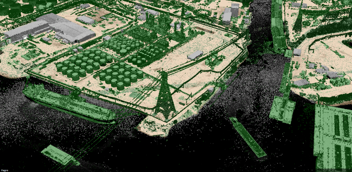
Lidar point cloud data along the Buffalo Bayou in Lynchburg, Texas, acquired in 2018 under Fugro’s previous StratMap contract for the Texas Department of Information Resources

Lidar point cloud data along the Buffalo Bayou in Lynchburg, Texas, acquired in 2018 under Fugro’s previous StratMap contract for the Texas Department of Information Resources

The award builds on Fugro’s decades-long experience providing lidar and imagery mapping services across Texas, including for post-hurricane flood assessment. Two unique capabilities available under the new contract include Fugro RAMMS, a fast and efficient coastal mapping solution, and Fugro SIMmetry, a GIS-based 3D visualisation and data management system. Together, these innovative technologies provide powerful Geo-data tools to help users maintain critical infrastructure and services, protect the environment and safeguard lives during major storm events. The contract also provides DIR and its partners access to Fugro’s full range of aerial mapping, road condition surveying and site investigation services, as well as to existing Geo-data libraries and Geo-data conversion and management offerings.

“We are pleased to continue our partnership with DIR on another StratMap contract and to expand the range of services available under this latest award,” said Dave White, Fugro’s Manager for Remote Sensing and Mapping in the Americas. “Our experience in Texas provides the foundation necessary to deliver precise Geo-data acquisition, analysis and management services in an efficient and cost-effective manner. We look forward to helping Texas achieve their geospatial goals over the next 5 years and to contributing to the state’s safe and sustainable future.”

About Fugro

Fugro is the world’s leading Geo-data specialist, collecting and analysing comprehensive information about the Earth and the structures built upon it. Adopting an integrated approach that incorporates acquisition and analysis of Geo-data and related advice, Fugro provides solutions. With expertise in site characterisation and asset integrity, clients are supported in the safe, sustainable and efficient design, construction and operation of their assets throughout the full life cycle.

Employing approximately 9000 talented people in 61 countries, Fugro serves clients around the globe, predominantly in the energy and infrastructure industries, both offshore and onshore. In 2020, revenue amounted to EUR 1.4 billion. Fugro is listed on Euronext Amsterdam.

Filed Under: Business, LiDAR, Top Press Tagged With: Fugro, lidar

About Editor

Glenn is a geographer and a GIS professional with over 20 years experience in the industry. He's the co-founder of GISuser and several other technology web publications.

Top Press

The Global Expansion of Aueshah: A New Era of High Jewelry

April 11, 2026 By GISuser

KARACHI, PAKISTAN. The international luxury market is experiencing a profound shift. Consumers are increasingly rejecting mass-produced goods in favor of rarity, authenticity, and emotional depth. … [Read More...]

State of Data Science Report – AI and Open Source at Work

September 10, 2025 By GISuser

AI and Open Source at Work … [Read More...]

Topcon Announces Landmark Expansion of Topnet Live Network Across USA

January 26, 2025 By GISuser

LIVERMORE, Calif.---Topcon Positioning Systems has announced a significant expansion of its Topnet Live reference station network, introducing 200 new geodetic stations strategically positioned across … [Read More...]

Space Flight Laboratory (SFL) Announces Launch and Deployment of NorSat-4 Maritime Monitoring Microsatellite

January 19, 2025 By GISuser

Seventh Satellite Developed by SFL for Norway … [Read More...]

HERE and BMW Group extend partnership on AI-powered mapping system

January 8, 2025 By GISuser

HERE and BMW Group extend partnership on AI-powered mapping system for automated driving and enhanced road safety … [Read More...]

Everest Base Camp Helicopter Tour, Helicopter Return Trek, and Manaslu Circuit Trek: Which Nepal Adventure Is Right for You?

November 6, 2026 By GISuser

Almost everyone planning a Nepal trip runs into the same wall. You want the big mountains, you have a fixed number of days, and every itinerary you read seems to promise something … [Read More...]

SFL Missions Inc. Confirms Successful Deployment of Six HawkEye 360 Radio Frequency Detection Satellites with Advanced Capabilities

October 27, 2026 By GISuser

MĀHIA, New Zealand, 26 October 2026 – SFL Missions Inc. today confirmed the successful deployment of six radio frequency (RF) detection and geolocation satellites for HawkEye 360 … [Read More...]

Canadian-Built RoadEng 12 Uses AI to Find the Best Location for New Resource and Rural Roads

October 17, 2026 By GISuser

Vancouver, BC, Canada, October 15, 2026 – North Vancouver-based Softree Technical Systems today released RoadEng Version 12, used in more than 75 countries to locate and design … [Read More...]

Beyond the Map: How AI Image and Video Generation Is Changing Geospatial Communication

October 14, 2026 By GISuser

Ask anyone who has shipped a GIS project what the hardest part was, and the answer is rarely the spatial analysis. It is almost always the communication. A site suitability … [Read More...]

From Maternity to Everyday Wear: Building a Wardrobe That Grows With You

October 14, 2026 By GISuser

When I think about maternity clothing, I feel the biggest mistake is buying too many things at once. During pregnancy, your body keeps changing, and something that fits well today … [Read More...]

Copyright gletham Communications 2015 - 2026

Go to mobile version