GIS user technology news

News, Business, AI, Technology, IOS, Android, Google, Mobile, GIS, Crypto Currency, Economics

  • Advertising & Sponsored Posts
    • Advertising & Sponsored Posts
    • Submit Press
  • PRESS
    • Submit PR
    • Top Press
    • Business
    • Software
    • Hardware
    • UAV News
    • Mobile Technology
  • FEATURES
    • Around the Web
    • Social Media Features
    • EXPERTS & Guests
    • Tips
    • Infographics
  • Around the Web
  • Events
  • Shop
  • Tradepubs
  • CAREERS
You are here: Home / Archives for surveyor

Virtual Surveyor Adds Productivity Tools to Mid-Level Smart Drone Surveying Software Plan

September 24, 2024 By GISuser

Create Surveys Faster at the Same Cost

Filed Under: Business, Featured TOP PR, Hardware, Top Press, UAV/UAS Tagged With: adds, business:, drone, featured, hardware, mid-level, plan, press, Productivity, smart, software:, surveying, surveyor, Tools, top, uav/uas, virtual

Virtual Surveyor Adds Planimetric Survey Functionality to Latest Release of Smart Drone Surveying Software

April 19, 2024 By GISuser

Faster Overall Workflow

Filed Under: Business Tagged With: adds, business:, drone, functionality, latest, planimetric, release, smart, software, survey, surveying, surveyor, virtual

Virtual Surveyor Provides Comprehensive Insights into Drone Survey Data with Addition of Profile View

November 17, 2021 By GISuser

Excavation progress over four different dates shown through the profile view.

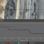
AARSCHOT, Belgium, 17 November 2021 – With the goal of giving surveyors a better understanding of the topographic data captured by drone mapping sensors, Virtual Surveyor has unveiled Profile View functionality in Version 8.4 of its popular surveying software. Profile View enables users to generate an elevation profile simply by drawing an onscreen traverse across any […]

Filed Under: Business, Featured TOP PR, LiDAR, Software Tagged With: lidar, surveyor

Virtual Surveyor Introduces Dropbox Integration for Easy Collaboration and File Access from Anywhere

April 6, 2021 By Editor

Sharing a Virtual Surveyor project externally to a collaborative team space.

AARSCHOT, Belgium, 6 April 2021 – Virtual Surveyor has introduced Dropbox integration in Version 8.0 of its popular drone surveying software. This means Virtual Surveyor users can now access their project files from anywhere while enjoying easy and affordable collaboration with team members and file sharing with external clients – even in low-bandwidth situations.

Filed Under: Business, DATA, Top Press Tagged With: lidar, surveyor, UAV

Virtual Surveyor Streamlines Volumetric Calculations for Stormwater Retention Ponds, Basins & Quarries

March 2, 2020 By GISuser

Virtual Surveyor Streamlines Volumetric Calculations

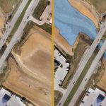
AARSCHOT, Belgium, 2 March 2020 – Virtual Surveyor has released Version 7.1 of its popular drone surveying software, introducing functionality to efficiently calculate volumetrics in quarries, mine pits, retention ponds, and other basins that fill with water. This new functionality complements advanced cut-and-fill mapping capabilities unveiled in late 2019.

Filed Under: Business, Software, Top Text Lead Story Tagged With: surveyor

Virtual Surveyor Unveils Terrain Lenses in Drone Mapping Software

June 4, 2019 By GISuser

Virtual Surveyor Unveils Terrain Lenses in Drone Mapping Software

Better Understanding of Topography

Filed Under: LiDAR, Software, UAV/UAS Tagged With: CAD, drone, lidar, surveyor, UAV

Recent Posts

  • Beyond the Gap: Maximizing Your ROI with a Strategic Bridging Loan
  • EzRemove’s Background Remover vs Transparent Background Maker — AI Tools for Effortless Image Editing in 2025
  • Top Luxury Tours in Ghana for a Unique Travel Experience
  • How to Monitor Performance of GIS and Mapping Apps Across Different Regions and Network Conditions
  • 5 Compliance Risks Your EMR Audit Tool Can Catch Before an External Audit
  • Apartment Movers in Abu Dhabi | Reliable Moving Services
  • 11 Best Ways to Farm Rare Brainrots in Steal a Brainrot
  • Navigating the Digital Casino: A Modern Guide to Security and Responsibility in Online Slots
  • Decode the Hidden Value of Your Old Vehicle and Turn It from Scrap to Cash
  • 8 Live Dealer Game Formats You’ll Find in Malaysia

Recent Features

Space Flight Laboratory (SFL) Announces Successful Launch & Deployment of HawkEye 360’s Cluster 11

FOSS4G NA 2024: The Premier Open Source Geospatial Conference Returns to St. Louis, September 9-11

Photographer Touch Reveal the Top Cameras, Lenses, and Photo Editing Tools of 2022

Digitalization and Simulation at the North Pole

Natural Gas District & GIS-Centric Asset Management

More Posts from this Category

Categories

RSS Career Tips

  • Four Characteristics of the Best Virtual Employees
  • 28 Tools to Conquer the Social Media Recruiting World
  • 8 Questions Employers Should Ask About Coronavirus
  • Jobcase Launches Free Unemployment Resource Center for Workers Impacted by COVID-19
  • Must-Have Gadgets and Technology for the Remote Office Worker


featured podcast

RSS Tech pubs

  • Sustainable supply chains take center stage -- product development guide
  • Optimizing Subsea Cable Uptime with Coherent OTDR Technology
  • How Marketplaces Are Evolving

RSS Computers

  • How the Cloud is Reshaping Virtual Desktops
  • Millennials as Brand Advocates - New Research Study Results
  • Vehicles Best Practices Installation Guide

RSS HR Tips

  • AWS GovCloud (US) Celebrates 10th Anniversary and a Decade of Digital Transformation in the Federal Government
  • Exploring the Impact of COVID-19 on Customer Behavior
  • The Pivot to 100% Remote Training in the Contact Center

RSS Gov Tech

  • 10 Legal Jobs You Can Get Without a Law Degree
  • J.D. Power Examines How the Inflation Reduction Act Reshapes EV Landscape
  • Making Telehealth Work for You: The Ultimate Guide

Copyright Spatial Media LLC 2003 - 2015

Go to mobile version