
Maxar’s satellites collected an extensive amount of new imagery on August 31st over the Gulf Coast and southern Louisiana that help to convey some of the damage caused by Hurricane Ida.
Use Google Maps Satellite Imagery Wisely to Avoid Dangers
The U.S. Department of Defense uses a tool called WorldView for military operations in the Middle East. With the advent of newer technology, the military has been able to increase its ability to plan and prepare for future operations. One such tool is the satellite imagery provider WorldView. In this article, we will look at […]
Maxar @MaxarTechnologies Satellite Imagery: Kabul, Hamid Karzai International Airport

Maxar collected new high-resolution satellite imagery yesterday (23 August) of Kabul that helps to convey visually the ongoing situation in and around Hamid Karzai International Airport. Large crowds of people can be seen at multiple checkpoints and security gates along the perimeter of the airport while several groups of people gather on the tarmac and […]
Tecta America Zero Uses Aerial Imagery to Innovatively Bring Excellence to America’s Roofs
The Challenge: Facing distant projects and buildings closed due to the pandemic, the Tecta America Zero Company needed a solution for viewing and assessing project sites that was effective and efficient.
Maxar Satellite Imagery: Dixie Fire, California
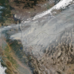
Maxar collected new satellite images on Sunday, August 8th of northern California and the Dixie wildfire that continues to burn and has become the state’s second largest wildfire in history.
National Imagery Summit SAVE THE DATE August 31, 2021 – September 2, 2021

August 31, 2021 – September 2, 2021 – 12:00pm – 5:00pm EST Daily
Satellite Imagery of Suez Canal and Stuck Container Ship @Maxar
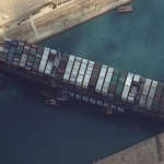
Maxar’s WorldView-2 collected new high-resolution satellite imagery this morning (March 26th) of the Suez canal and the container ship (EVER GIVEN)–a 1,300-foot ship operated by the Taiwan-based Evergreen Group–that remains stuck in the canal north of the city of Suez, Egypt. In today’s satellite imagery, multiple tug boats are positioned alongside the ship and dredging operations […]
Maxar Satellite Imagery: SpaceX Starship Facilities, Boca Chica, Texas

Maxar Technologies’ WorldView-3 satellite collected new imagery on December 10th of the SpaceX production and launch facilities in Boca Chica, Texas.
Satellite Imagery: Aftermath of Hurricane Iota in Providencia Island, Colombia @Maxar

Maxar Technologies collected new satellite imagery yesterday (November 21st) of the small Colombian island of Providencia, which suffered extreme damage from Hurricane Iota. Nearly all of the island’s infrastructure was destroyed from the powerful category 5 storm that struck the island on November 16th
Satellite Imagery @Maxar : Southern California’s Blue Ridge and Silverado Wildfires

Maxar Technologies collected new satellite imagery yesterday (October 28th) of the Blue Ridge and Silverado Wildfires that rapidly spread over the past couple of days in southern California, threatening multiple cities including Yorba Linda, Chino Hills and Irvine, California.